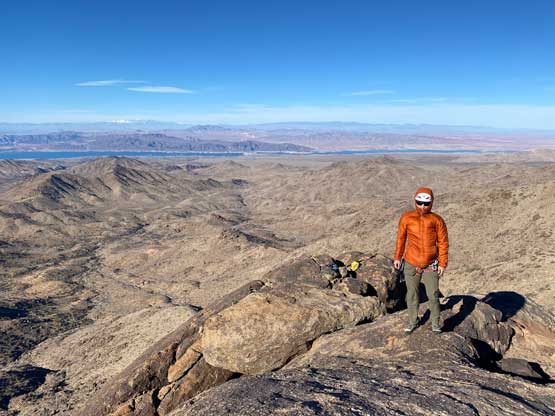
Jumbo Peak (NV)
January 7, 2022
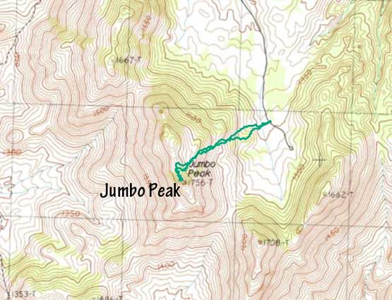
1756m
Lake Mead East, NV
Jumbo Peak is the hardest “P1000m” or even the hardest “P600m” objective in the broader vicinity of Las Vegas as the easiest route involves 4th and low 5th class climbing. Asides from the technical challenge this peak locates in a remote area to the east of Lake Mead that requires over 50 km of driving on dirt roads just to get in. On the bright side if one can drive to the road’s end then the ascent would be a short one with under 300 m elevation gain. The drive does not require the most aggress 4×4, high clearance vehicle but does require the vehicle to be robust and reliable. This was my 19th day in a roll of peak-bagging in the U.S. desert states so I was happy to do an objective that did not require much physical effort. Prior to this trip I knew nothing about Jumbo Peak and its challenging summit block. Adam made the suggestion to Rob and I as he knew that this is the one “P1000m” objective that Rob needed a partner. After briefly looking at the route description Rob and I instantly agreed. We made sure to dig the crap out of all kinds of “beta”, as to get this job done we absolutely had to stay on the easiest route.
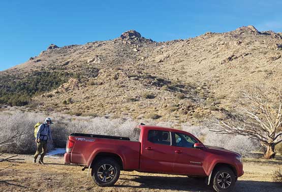
The shear amount of driving on dirt roads meant Rob’s rental Rav4 might not be the most suitable. I volunteered to drive the Tacoma even though it’s definitely not the cheaper option. We basically paid more money for extra robustness. Most parties did this peak with at least one night of car-camping but we decided to just day-trip Jumbo Peak along with Mica Peak from Las Vegas. Rob and I woke up at 4 am in Adam’s home and drove all the way north to Mesquite when it’s still dark. From there we turned south towards Whitney Pocket. The first 30 km or so was actually on pavement but the pavement was actually worse than the dirt portions with shit ton amount of pot-holes. From Whitney Pocket we turned south following the “New Gold Butte Road” on Gaia map wrapping from the north to west and finally to the south side of Gold Butte and Mica Peak. The roads on the Gaia map were excellently labelled so we made no mistake on all junctions and had no problem driving to near the road’s end. The drive was easier than expected overall.
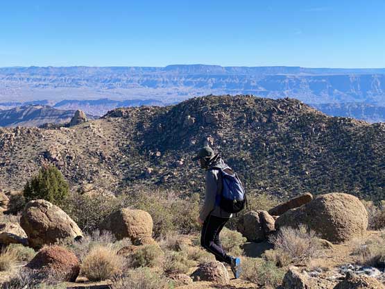
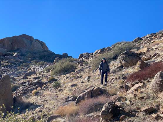
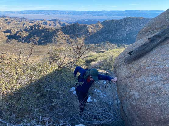
The general bearing of the approach was to aim at the north side of the summit block. We were hammered by strong winds right from the parking lot. The lower slopes were mostly easy but nearing the summit block we entered a maze of car-sized boulders. To work around those boulders we got sucked into some bramble types of bushes. I learnt once again that bushwhacking in the desert was a horrible idea. Those brambles made BC’s Devil’s Club field like a walk in the park. We made some mental notes to descend a route further north away from the summit block a few hours later, as that area looked to be less vegetated. Once onto the north ridge we had to negotiate more car-sized boulders with some 3rd class scrambling to approach the base of the summit block.


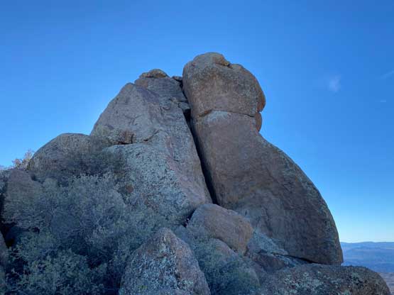
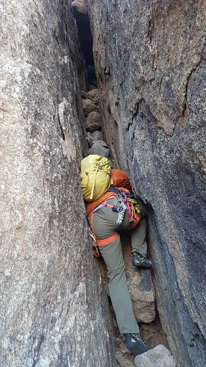
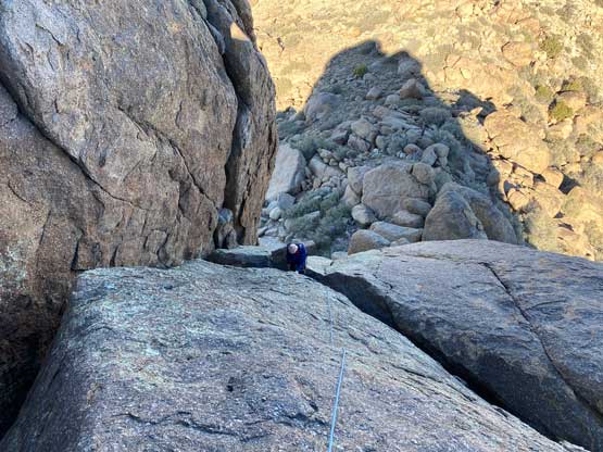
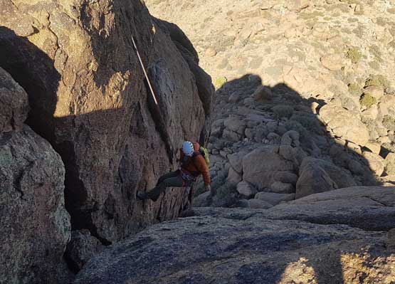
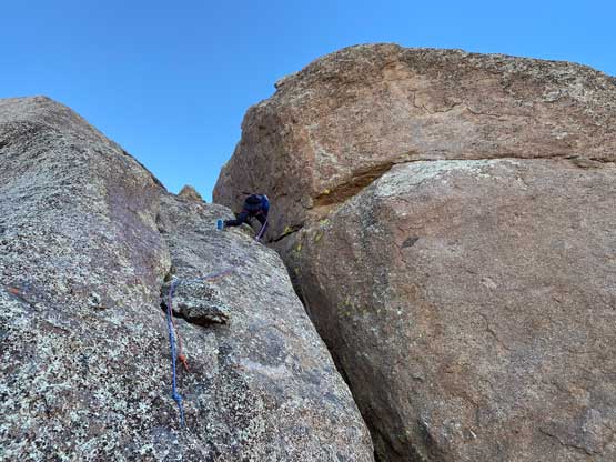
It’s very easy to locate the correct chimney as that’s basically the only option. The route looked insanely steep from the bottom, so we donned harness and rock shoes. We carried two 30-m ropes and a bunch of trad gears so both of us had to carry backpacks, which made the chimney even more treacherous. We both ended up taking the backpacks off to just push them up the chimney as we ascended higher. The moves inside the chimney weren’t exposed but awkward. Nearing the end of this chimney I ducked underneath one boulder and crawled back across the top of it to access a “mid-level ledge” that’s also the base of the low 5th class slab pitch. Rob did something different here. I knew there’s a less-technical option to completely tunnelling through using a rabbit hole (with head-lamps on), but I wanted to check out the 5th class slabs first to make a decision from there. The slabs appeared very doable so the decision was easily made. There was nowhere to place any pro so I basically just dragged the rope up. The climb turned out a bit harder than appeared but still well within my comfort zone of soloing. The rock texture was not the most secure. I started by scrambling up the diagonal ledge out to the climber’s left, then traversed a lower-angled part of the slabs back climber’s right to get onto a small arete feature. I climbed the arete upwards aiming climber’s left again, and traversed right at the very top to the pre-existing anchor boulder. After belaying Rob coming to this spot we both untied from the rope and easily scrambled to the true summit of Jumbo Peak.


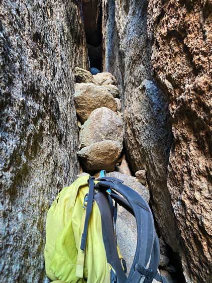


The summit was windy and cold so we didn’t linger any longer than necessary. After scrambling back down to the belay station I set up the rappel using two 30 m ropes tied together. I had read somewhere that two 30-m ropes would get us all the way to the bottom. I went in first and made halfway down the slabs beside that chimney. I could not see whether the bottom of the rope could reach the ground due to convexity blocking the vision, so carefully swung into the chimney and just rappelled the chimney. The rope could not reach the bottom of the chimney so I untied and down-climbed. I then scrambled up a class 4 step to have a better inspection of the bottom of the planned rappelling line and still couldn’t judge whether the rope would reach the bottom. Rob went down and proved that the ropes indeed could not reach the ground, so he had to make an even-sketchier swing into that chimney to down-climb. I knew the ropes would get completely stuck had we both rappelled the chimney and I was very correct. I ended up climbing almost the entire way back to the anchor to finally free the ropes. On the bright side I no longer needed to climb with a backpack on, so this was rather enjoyable on the second round. This time I cleaned the rope from that “mid-level ledge” and just down-climbed the entire chimney with the ropes wrapping around my neck.

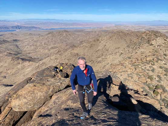
We spent our time at the bottom of the chimney to put all the gears back into the backpacks. On the descent we paid more attention to route-finding and generally avoided bushwhacking. There was one awkward-ish step in that car-sized boulders field where we found a new rappelling cord. I cleaned it up as that step would not have required a rappel for those aiming to summit Jumbo Peak. The rest of the return was mostly done by retracing our own GPS track made on the ascent. We soon made back to the truck and moved on to Mica Peak, a much easier objective that’s only 2 feet lower. When Adam pointed out Mica Peak being only 2 feet lower Rob and I knew that we must bag it just in case.