Mount Lamont
April 29, 2022
1994m
Sloquet Creek / Harrison West, BC
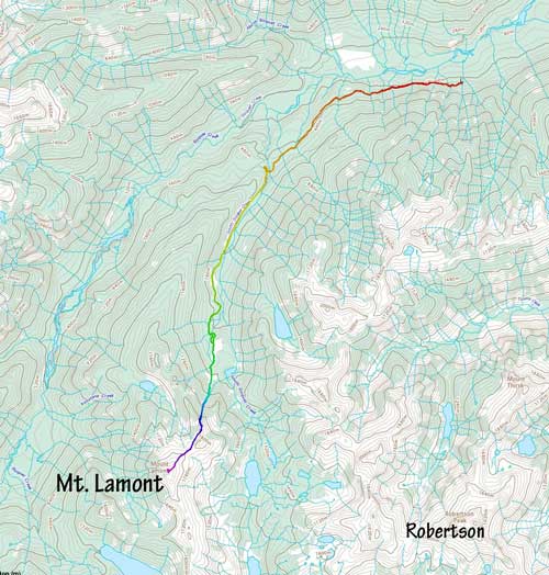
Mt. Lamont locates in one of the most remote regions in SW BC that few people asides loggers and die-hard peak-baggers had even heard about. The most notable objective in the immediate vicinity is Robertson Peak that a few of us ascended in April 2021 via a new route. Most of the smaller peaks in the area have either zero or one recorded ascent and that includes Mt. Lamont. This peak locates on the west side of Robertson Peak, boasts over 600 m prominence above Lamont/Robertson saddle and overlooks the divide between Sloquet Creek and Stave River. The only logical access point is the end of “South Sloquet FSR”. This road is not frequently used like the main Sloquet FSR that leads to the hot springs but thankfully Matt J. had gone in a week earlier to scope things out. The report was that we could drive to km-5 leaving the remaining 6 km to be walked, and the road was “definitely dying”. The area is known for horrendous bushwhacking so the most practical time is “early spring” when a thick snowpack reaches down to lower elevation zones. This year had been particularly wintery so we made the bid on the last weekend of April.
Matt and I decided on Friday as that had the most favourable weather forecast although clouds were still a guaranteed thing. There had been zero bluebird day in this entire month so we considered the weather to be “decent” whenever rain/snow wasn’t in the forecast. The two of us each had our own planned route. There was absolutely no “beta” whatsoever since we couldn’t even find a sure reference if this peak had been climbed or not. Robertson Peak had seen only 4 ascents before 2021 so I wouldn’t be surprised if Mt. Lamont had not been climbed. In any case Matt’s route traverses further beyond the end of the overgrown FSR to Lamont/Robertson saddle and ascends the gentler east slopes, whereas mine shoots straight up a 700-m chute/gully onto the NE Ridge system. My route ascends and traverses some big and consequential terrain but has less uncertainties in the below-treeline zone. Our route would not diverge until the end of the road so the decision would be made in field at the last minute. Nico and Phil joined the team so we had a strong crew for the trail-breaking. The estimated distance and elevation was about 30 km/2000 m and the drive on logging roads would be 160 km round trip so we absolutely had to be fast and efficient.
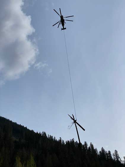
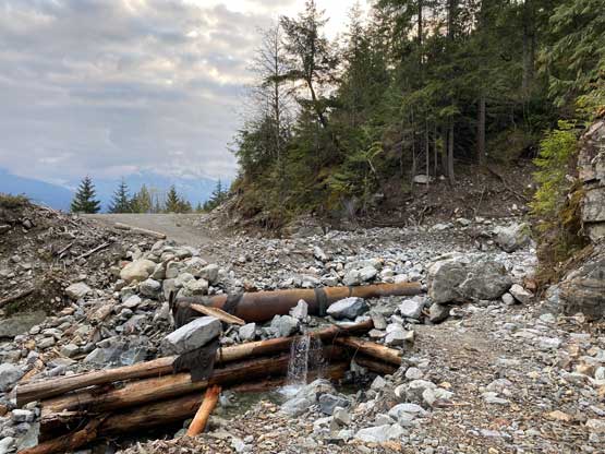
I drove over to Matt’s home the night before and got a couple hours of sleep. The four of us then grouped at 3 am and squeezed into Matt’s truck. We then cruised up Sea to Sky corridor to Pemberton and down south onto In-SHUCK-ch and then Lillooet West FSR. The road condition was really good such that we could easily cruise at 80 km/h. Matt used to drive at 120 km/h on logging roads but we played more cautiously this time. That was probably a good thing as we had a few close encounters with on-coming traffics that required slamming hard on the break. The turn onto South Sloquet FSR was signed but immediately we came to an active heli-logging site. Thankfully nobody was there to block us so we quietly drove through. This proved to be a risky decision but more on that later. There were a few sink holes and one long stretch of washed-out section that could only become worse as the spring-melt continues. Matt handled them without a problem and got us to the driveable end just like the attempt he made a week earlier.
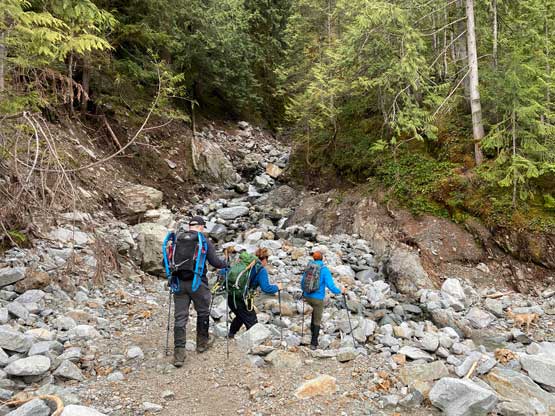
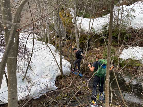
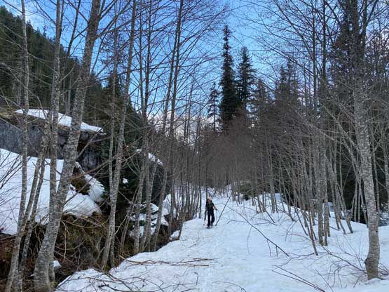
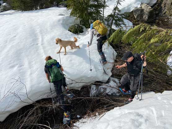
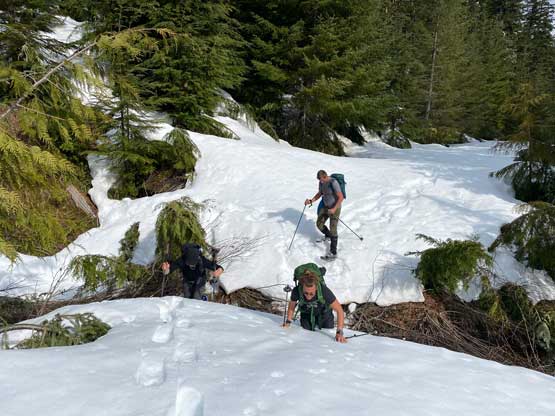
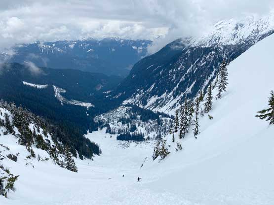
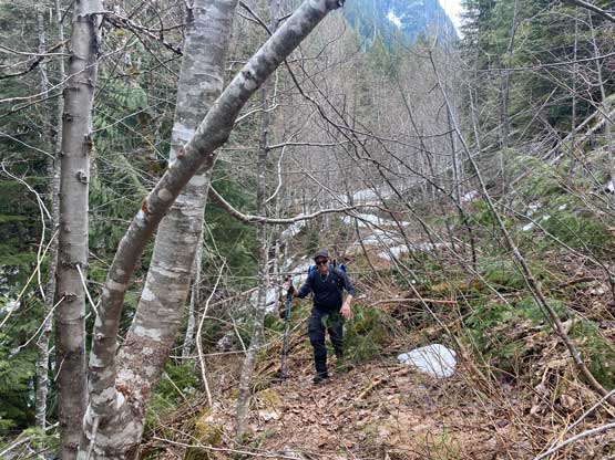
Nico and I opted to wear trail-runners and carry mountaineering boots, whereas Phil and Matt used the “middle ground solution” that was to use hiking boots for the whole trek. The 6 km trek to the end of the “good road” was quite a slog with some up-and-downs. Within 1 km beyond where we parked there were at least two wash-outs that would stop all motorized access. In other words, this road’s doomed to die in a number of years unless the logging company can reactivate the area. We encountered patchy snow near the end of this 6 km stretch so I ditched the trail runners and swapped for mountaineering boots at the spur road junction. The first kilometer up this spur road was mostly dry and the bushwhacking was not nearly as terrible as expected. Within 20 minutes we started to encounter continuous snow and that’s it for the bushwhack. We did still have to deal with alders even after strapping the snowshoes on, but nothing really worth noting by this area’s standard. The trail-breaking was a different matter though. The overcast skies had successfully trapped the heat such that there had been no overnight freeze whatsoever so we’d be dealing with the west coast’s slurpee and potato soup from the beginning of the day. Numerous creek crossings presented some additional challenges as the snow bridges were already collapsed.


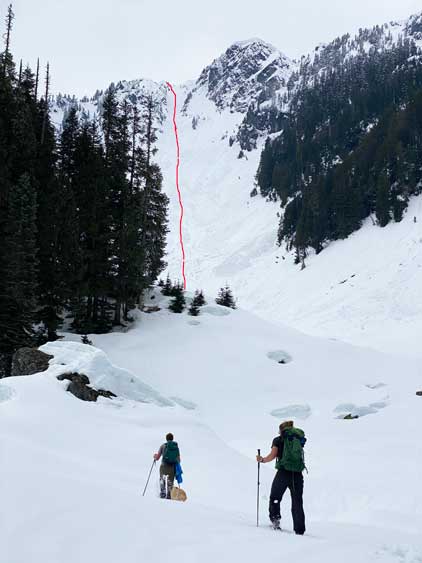
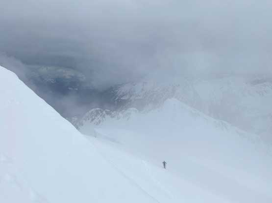
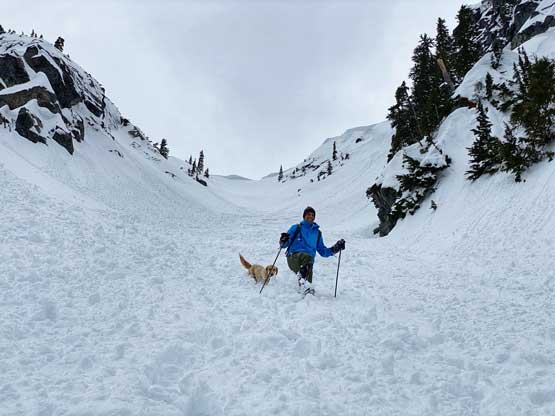
Matt and I had some discussions about the conditions and the conclusion was to shoot for the shortest distance using my proposed route. The avalanche chute was a massive one, gaining over 700 m in just over 1 km distance. Nico and I took turn breaking trail and that was a tiring game. Lower down we tried to stay on the avalanche debris but the ground unevenness was painful on our ankles. Whenever I took the lead I would just post-hole up the more-homogenous snow slopes but the post-holing was mostly calf to knee deep. About halfway up we finally started to hit some supportive crusts but then there came the fresh snow. Nearing the top of the chute we were post-holing knee deep in the fresh snow and the steep grade (40 degrees) required us to put in some switch-backs. We veered climber’s left near the top and directly popped onto a sub-summit on Mt. Lamont’s NE Ridge system where we took one long break. The steep uphill is definitely my strength. I had been pushing the speed in this stage as I did not want to stay any longer than necessary in this chute with some massive cornices dangling above ready to drop.


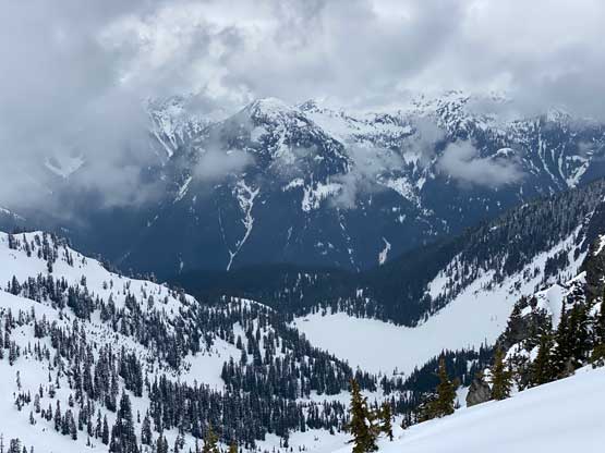


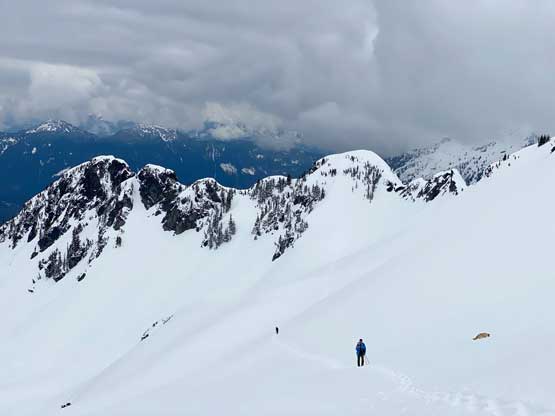
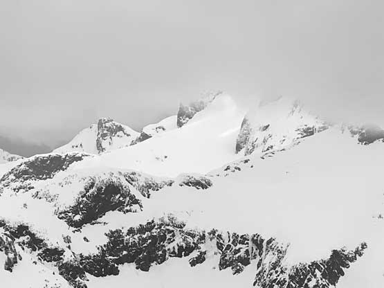
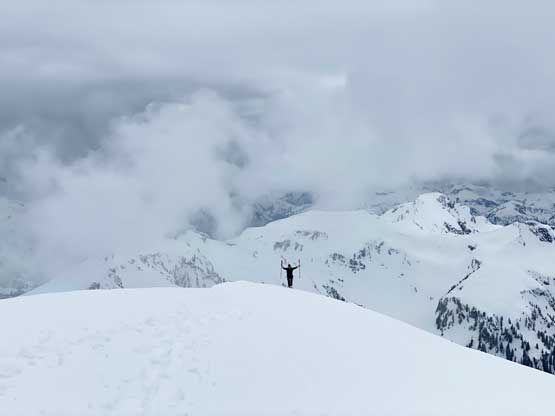
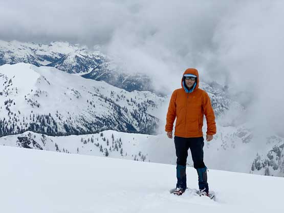
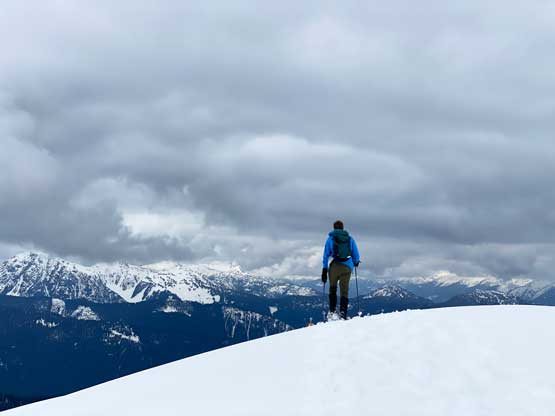
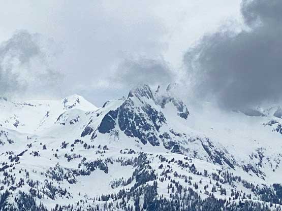
Immediately beyond this sub-summit we faced a steep down-climb losing about 50 m elevation. I took a slightly different line than the rest of the crew. We all had to take snowshoes off. The others walked off the 45-degree slope while I down-climbed facing inwards. The post-holing became waist deep as soon as I started facing outwards so the snowshoes were strapped on very soon. I then led us traversing across the NW Face of another sub-peak to Mt. Lamont’s NE Ridge. I did this section as fast as I could as well, as the traverse was very steep with bad run-outs and cornices threatening from above. Nico caught up with me and broke trail most of the way up the final stage. The upper NE Ridge wasn’t as easy as we hoped for with two cliff bands/vertical snow drifts requiring us to traverse leftwards onto the east face. The grade was mostly 35 degrees meaning we could keep the snowshoes on. The very summit was guarded by a large cornice but we found a break on the climber’s left side and minutes after that we were on the summit. The views were not as dramatic due to the clouds but at least we were not in a white-out.


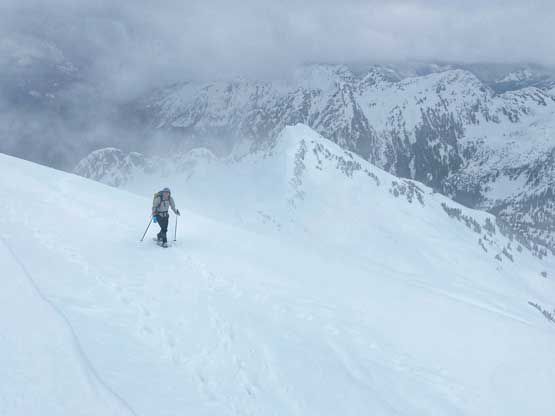

After about 15 minutes we all started the descent, now with Matt leading a furious pace running down the NE ridge back to that col. Running downhill in this wet and heavy snow was definitely not an easy fair and required very strong leg muscles. We then power-walked the traversing stretch and re-ascended that sub-summit using Matt’s route. We managed the re-ascent without taking the snowshoes off. The descent of that 700-m chute was as awful as one could expect thank to the terrible snow conditions. I knew it was going to be a shit show, so went ahead while the others took a break on that sub-summit. I started with wearing snowshoes and doing jump turns as I found this way puts the least stress on my joints and muscles. The key was to not descend too fast, but in no time Matt and Nico caught up and passed me post-holing on foot so I had to speed up. I kept the snowshoes on until the slope became a little bit firmer but as soon as I took the ‘shoes off I would still sink hip deep. The post-holing in this conditions was pretty hard even on the downhill so eventually we all switched to the glissading mode. That was actually the game changer as otherwise we would have to spend at least half an hour more on that slope. Eventually the grade became too flat for glissading so we put the snowshoes back on, and what a shit show that was. It was quite a magic that nobody broke a leg or a pole.


Once everyone’s off the fire zone we followed our own tracks back onto the logging road. The snow conditions were not any easier on the road with additional post-holing on our own tracks. Matt and Nico led a short-cut at one point that did not turn out very pleasantly. I knew this was going to suck as I paid attention to the terrain on the way in, but I was too far behind to communicate, so reluctantly followed as we might as well suffer together. Immediately following this short-cut was a creek crossing that required some detouring and re-ascending. And then we were on a mission mode all the way back to where I ditched the trail-runners. I basically walked as fast as I could ever do on snowshoes as if I was in a fitness training session and still barely able to keep up the pace. Phil was a couple minutes behind me and the two of us eventually gave up on the speed and walked the remaining 6 km back to the truck on a more leisurely pace. Our round trip time was 10.5 hours covering 30 km and 2000 m elevation gain. Considering the horrendous snow conditions this was definitely a work-out and my legs were still sore even two days after the hike.


Just when we thought we would be home in a few hours we got blocked by the heli logging machine. We all had some inReach devices so the worst case we could text and call for help, but Matt went out to inspect the machine. There’s one metal bar that we managed to move around by some dead-lifting and sure enough Matt managed to squeeze his truck through with a couple inches of spare on both sides. Breathing in a huge sigh of relief two hours later we were back in Whistler for some massive burgers and two more hours later we were back to Vancouver. I had no idea how Matt managed to keep himself awake especially considering this was his third day in a roll of peak-bagging… I then had one extra hour of driving as I live in White Rock. I had to fight really hard with fatigue but I did manage to get home without falling asleep while driving and that concluded this successful 21-hour home-to-home outing.