Gunung Prau
August 11, 2023
2600m
Java, Indonesia
The Dieng Plateau or the Dieng Volcanic Complex boasts at least a dozen peaks and Gunung Prau is the highest. This is a very touristy area in Central Java due to the good views and the easy access. The Dieng Village situates at 2000 m elevation making the ascents of these peaks rather trivial. I was surprised by the lack of information on peakbagger.com as Gn. Prau boasts over 900 m prominence and is extremely easy, but I found good “beta” on the Gunung Bagging website. There are two popular routes. Most people would prefer the longer but gentler NW Ridge which also has a higher starting point, but Adam and I decided to take the southern approach as it has the shortest distance. We always prefer more elevation gain over longer distance.
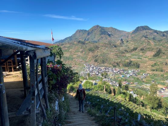
This was supposed to be a “rest/driving day” before the grueling ascent of Gn. Slamet but we couldn’t resist the temptation to bag another P600m objective. Further research made us to jack up the ambition to include the nearby Gn. Bisma. These two peaks would take roughly 2 hours each, so that shouldn’t be a big deal. Our driver slept with us in our guesthouse and the three of us left at 6:30 am. The drive to the trail-head only took 5 minutes so there’s no point in waking up too early. The morning was also very cold and I still didn’t buy a new jacket yet (mine was lost on Ijen). There were actually ojek services and they could drive us to Pos 1 but that could only save 100 m elevation gain and 1 km distance. I would still take it for simple reason of why-not but after the scary ride we just had on Gn. Sindoro we decided to walk this time. It’s not that much of extra work anyway.

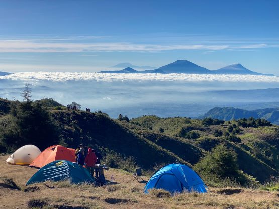
The lower half of the mountain was entirely made of staircases, my least favourate form. The bottom of the route was on concrete staircases, which yielded to stones and eventually to wood/mud but we were still making those step-up moves. The upper half of the trail to “Sunrise Camp” on SE Ridge was no longer on staircases, but just as steep. The cooler morning temperatures combined with the dense forest made this a rather enjoyable hike, and for once we didn’t have to suffer in the heat. The “Sunrise Camp” was very aptly named. We did not come up here for sunrise but I could imagine how cool to spend a night there. There were at least a dozen tents and I assumed all of them had a great time.


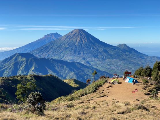
The ascent from here to the true summit was rather boring. If you aren’t a peak-bagger you can stop at the “sunrise camp” and call it, but Adam and I must continue to put a check mark on this objective. The main reason we picked this southern approach was the shorter plodding distance on the summit plateau to reach the true summit. From the other side we would have to plod twice as long. We also somehow missed the main trail and entered an area that’s clearly used by the campers to take their shits, but we quickly found the correct path afterwards. The true summit did offer some additional views towards the west down into the village.


We had already decided to do the secondary objective so there wasn’t that much of extra time to kill. We made a quick dash back to the camping area to take a short break, and then made the 600 m descent in a single shot. My feet were not particularly happy about the rocks and the staircases but I could suffer it through. We finished the round trip in just over 2 hours. Our driver was not at the trail-head but we quickly found him in a larger parking area nearby, and not doing much lingering we quickly made our way to Gunung Bisma, our next objective.