Mount Edith
July 21, 2012
2554m
Banff, AB
My original plan was to join Wil Tabak for the Mt. Lougheed I-III traverse but the weather had some other plans. By the time we met in Canmore the weather was much worse than forecasted so we had to figure something else out. We still wanted to do a “difficult scramble” and Wil pointed out Mt. Edith and I agreed.
Usually when you change your plan at the last minute, you’re very likely to make mistake on trip planning part. By the time we arrived at Cory Pass trail-head, I realized I left several things in my car – helmet, the Kane’s scramble book and my sunglasses… Wil didn’t bring his Kane book neither. I did have some vague memories from other people’s trip reports but those weren’t reliable. What I could remember was: from Cory Pass the north summit required scrambling through a steep chimney. The traverse to the center peak was supposed to be straightforward while going to south peak was more difficult and required squeezing through a tunnel. But given the fact it’s a “Kane’s scramble” there gotta have a beaten path along with a good number of cairns.
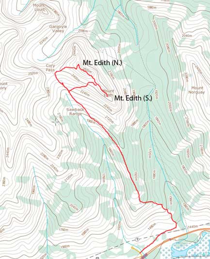
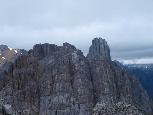
Mt. Edith scramble route
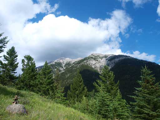
Not having a helmet was another concern given the steep and loose terrain along this traverse, but nonetheless we started the trudge up Cory Pass trail. From a hiker’s perspective, this trail was quite steep especially for the first kilometer or so. I felt very short on energy for some reason. Probably I should have done some warm-up, but I rarely have the same problem in the past trips without warming up. I think everybody has his bad days for once in a while. The impressive Mt. Louis suddenly showed up when we topped out on Cory Pass. “That’s the therapy”, said by Wil. And I agreed. If you really want to see the impressive rock formation in Sawback Range, I highly suggest you to go up Cory Pass. Now I know why so many people like this trail!

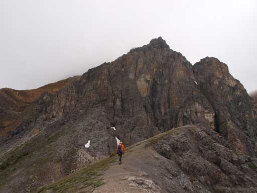
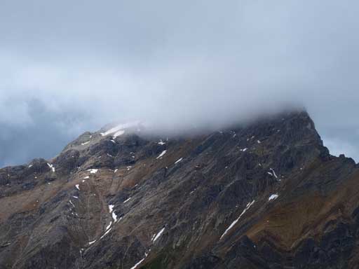
The south peak of Mt. Edith seen from Cory Pass Trail
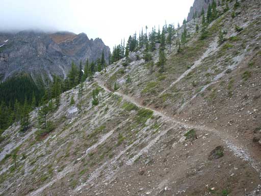
Cory Pass Trail
This is looking towards Mt. Cory from Cory Pass
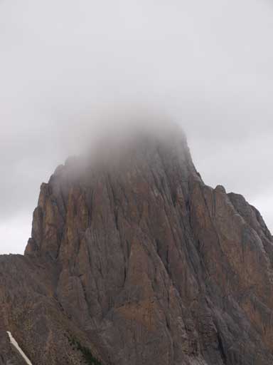
Mount Louis
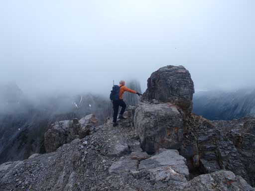
I took a short break and then we followed a beaten path to the base of the cliffs ahead. Now there appeared to have a few “chimney options” and we didn’t know which was the correct one. Wil found a cairn towards climber’s right and we followed to the col between 1st and 2nd peak. There’s another chimney on this side… Okay, since there were cairns, we decided to took this one. We then followed the ridge up for a short while before realizing the terrain ahead was extremely exposed and overhanging. I wanted to just re-trace our steps back to the col, but Wil was able to find another chimney which could bring us directly down.

Wil searching for a possible way up

We had to down-climb this chimney to get back on track
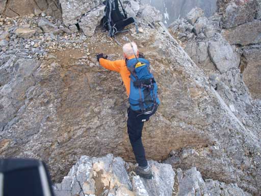
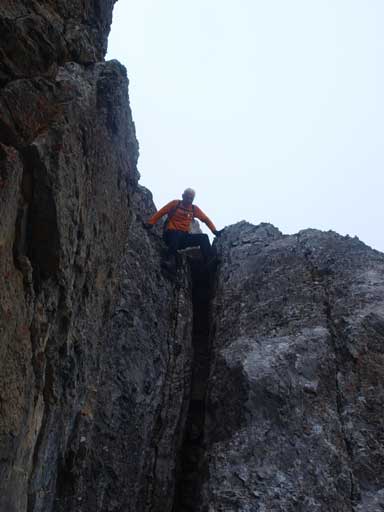
We then went to check out climber’s left. We traversed around over slightly exposed ledges and found a broad gully on that side. The gully was super loose and rockfall was a real hazard especially given the fact we didn’t bring helmet along. After this part, it’s only 5 min away from the summit of north peak. However, to get there, we had to step over a half-meter crack. You can jump over it as well. But if slipping into that crack, you would be in a really bad shape…
Wil approaching the summit

However, we had to jump across this rock crevasse
Mount Louis
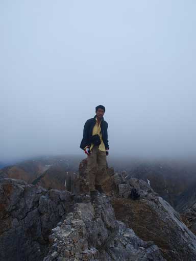
Me on the summit of N. Peak
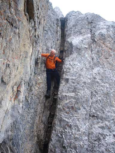
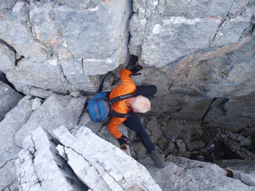
We didn’t linger long because our objective is the traverse, not just the north (true) summit. We were able to find the correct chimney mentioned in Kane’s book. It’s steep and narrow, but you also have lots of holds so it wasn’t too bad. Considering the low exposure level, Wil thought it’s more like moderate. I would say it’s still “difficult”, as the nearby Mt. Norquay felt for sure easier than this..
Climbing back over the rock crevasse
Wil starting the chimney down-climb
In the middle section
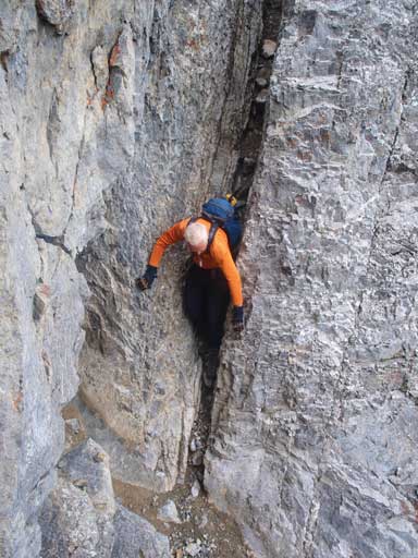
Fishing the last few moves
Follow the beaten path, we soon arrived at the north/center col. To get to center peak, we followed the trail skirting around the first cliff band on climber’s left, on slightly exposed ledges. The ledges looked exposed from north peak, but when we got there, it wasn’t bad at all. Then we had to trudge up another loose gully but not as bad as the one we ascended on the north peak.

Ascending the loose terrain towards center peak
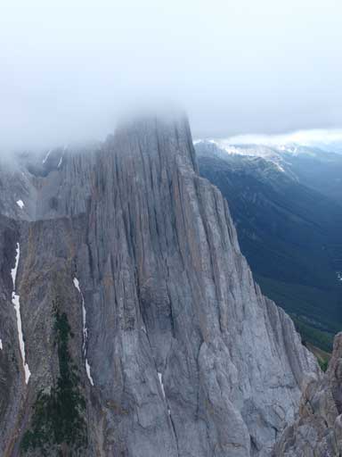
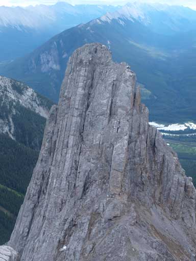
From the center peak, we could have a better perspective of our next objective, the south peak. It looked intimidating from this angle just like the nearby Mt. Louis… We were able to find the steep gully leading down to center/south col. From above, this one looked just like the previous two gullies, but when we got into it, we found it’s not as loose. Good. There was even a good scree run on the lower part, which was a bonus for our knees.

Wil on the summit of center peak
Zooming-in towards the S. Peak

We came down this gully from center peak

The south peak looks more like a smaller version of Mt. Louis
The south summit is rated more difficult by Kane, and a narrow tunnel is involved. Since we had to go back the same way, I just left my backpack at the col. Following the obvious path up, the tunnel is the first obstacle we encountered. Kane mentions your “size factor” but the tunnel was wide enough for every scrambler I would say, and also considerably easier than the steep chimney on north peak. There were tens of cairns after the tunnel, and route-finding wasn’t a problem for the rest. The cairns led us traversing climber’s right then up, and we were soon facing the next obstacle, a 3 m slightly overhanging step. The holds were solid, but because of the overhanging factor, you need some techniques or strong arm, or long legs. The consequence of falling is minimal, but like I said earlier, you need strength for this step. Personally, I feel this type of stuff harder. A few minutes ascending the broad south ridge broad us to the summit.
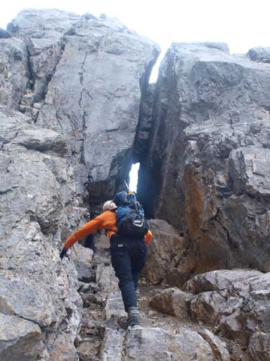
Wil approaching the tunnel
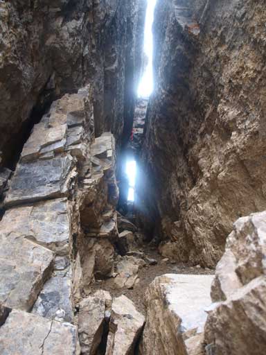
Inside the tunnel
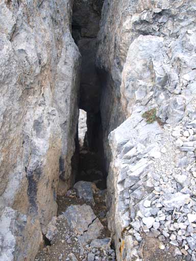
Looking back through the tunnel

Wil finishing the last few steps on S. Ridge
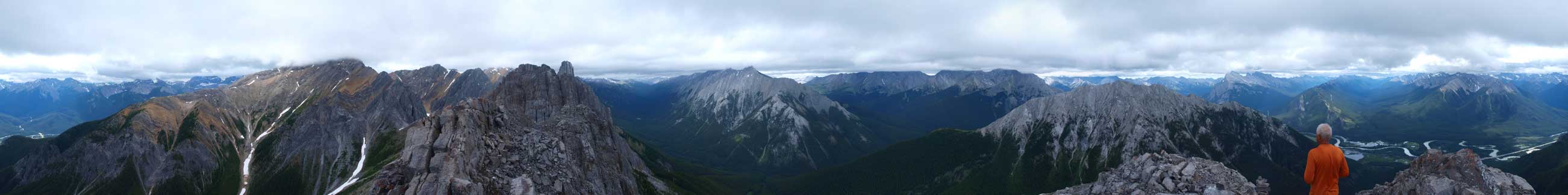
Summit Panorama from the S. Peak. Click to view large size.
Mount Louis on right; Center and North Peaks of Edith on left

Impressive names on the summit register including Barry Blanchard
Mount Cory
We retraced our route down. As I mentioned earlier, coming down that overhanging step was harder as a long reach was required. Wil did it more comfortably, and I did it okay. We came straight down from center-south col towards Cory Pass trail. Once on the trail, we saw hordes of hikers. Oh yeah, it’s Saturday with good forecast… The sky finally cleared up and we were able to take some nice photos of Bow Valley, Mt. Rundle and Mt. Norquay.
Descending a slightly overhanging step
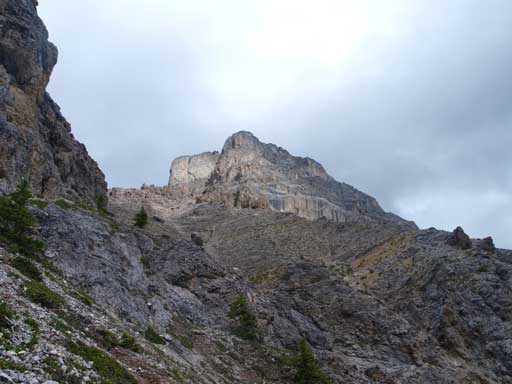
Looking back at the South peak of Edith

Mount Rundle and Vermillion Lakes
Mount Norquay
I still felt quite tired by the time we finished the trip, but at least I could have a good rest in Canmore. The weather was clearing up for the next day so as you know, something else had to come down!

Im a 22 year old college student and I submitted Mt Edith with one of my friends. We are both in great shape but man did this hike kick our asses!
We found the “Mount Edith Ascent” trail was much easier than the “Mount Edith Decent”.
In addition, we went up on the “decent” trail. That meant we had to go up the “Gully” you mentioned. It was very exposed and was some pretty technical climbing.
We were certainly not ready for it – I guess we need to read more beforehand. congrats on submitting too!