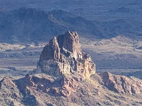
Thumb Peak (AZ)
December 28, 2021
1038m
Castle Dome Mountains, AZ
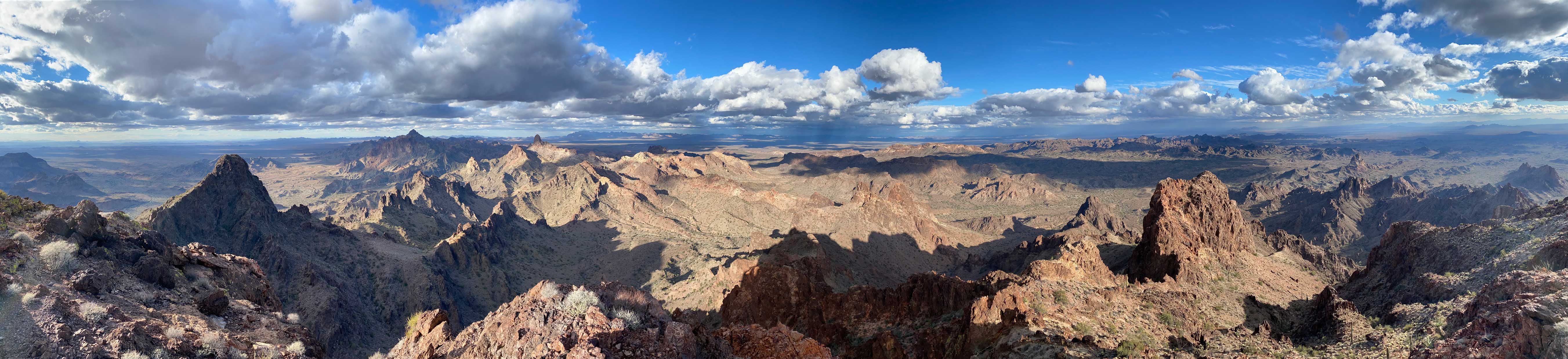
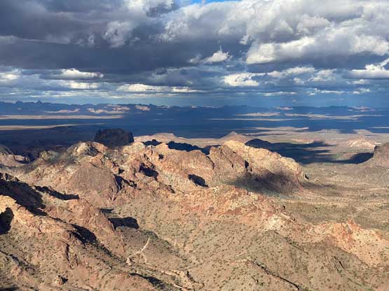
Thumb Peak is a remote summit in the middle stretch of Castle Dome Mountains about 50 miles to the north-east of Yuma in the state of Arizona. This peak is not as high as Castle Dome Peak itself, but still boasts over 300 m prominence and an iconic profile recognizable from far away. The hardest and the most unknown part of this ascent is the drive-in, as one must negotiate about 50 km of dirt roads (each way) with the second half being extremely rough such that it’s only passable in a vehicle no worse than Jeep/Tacoma/4Runner or better, an ATV. When Adam and I planned this objective we had little idea about the roughness of this access road so had we tried in Adam’s Subaru we would not have gone far. Thankfully Matthias joined us with his 4Runner with aggressive tires so we were set for this adventure.
Earlier in the day we had just explored and scrambled Red Bluff Mountain so we didn’t have a lot of extra time. We figured that it’s still possible to complete the scramble of Thumb Peak in daylight time but the drive back would likely need to be done in the dark. The first half of the dirt roads following the standard Castle Dome Peak’s access weren’t too bad such that we decided to just drive in with two vehicles. Just before the junction with Big Eye Mine Road we ditched Adam’s Subaru and piled into Matthias’ 4Runner and as soon as we turned onto this Big Eye Mine Road the going became extremely rough and sustained. For a while we were following a group of ATVs and it started to feel like this was the playground for the ATVs and modified Jeeps. The direction of this road was also weird that we did a massive roundabout from the west to south to east and finally to the north side of Thumb Peak near Slumgullion Pass, with lots of up-and-downs especially along that first stretch going south. It’s pointless to go into the details of this drive but any vehicle with 4×4, high clearance and all terrain tires could make it, but expect 2 hours each way on this Big Eye Mine Road even with a mindset of not caring how much the truck’s maintanence would cost…
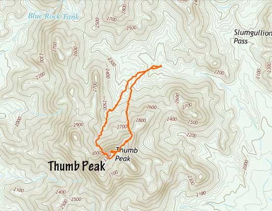
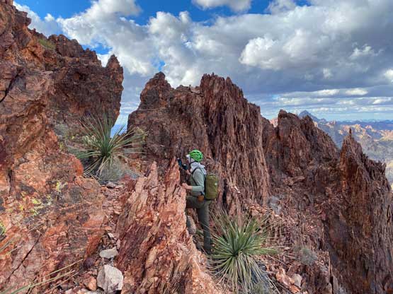
The Gaia’s map had been very correct about this drive-in so we never encountered any navigation difficulty. We showed up at the end of the road with at least half a dozen Jeeps and ATVs but none of them seemed to be there for hiking. From where we parked we only had about 1.5 km distance and 350 m elevation gain to the summit, so we did have plenty of time. None of us had done detailed research but we did come prepared with a screen shot of the route’s map, from Stav Basis’ website. Unfortunately Stav does not provide GPX files to download so we only had a rough idea where he went. The general bearing was to aim at a notch feature on the lower NE Ridge and follow the ridge to the summit with scrambling no harder than class 3. The ascent towards that notch was harder than appeared with lots of side-hilling on loose terrain. We also had to pay close attention to all sorts of the cactus plants as we were in a higher elevation zone than the previous few days that the slopes were much greener.


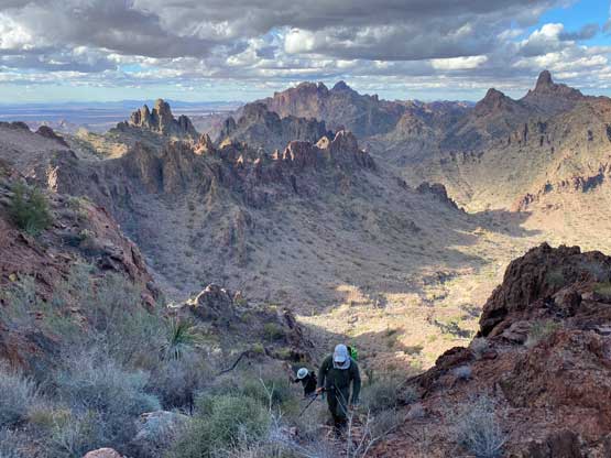
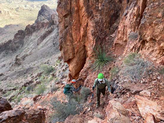
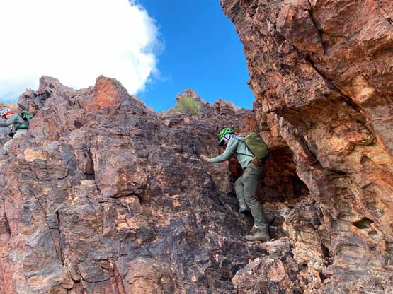
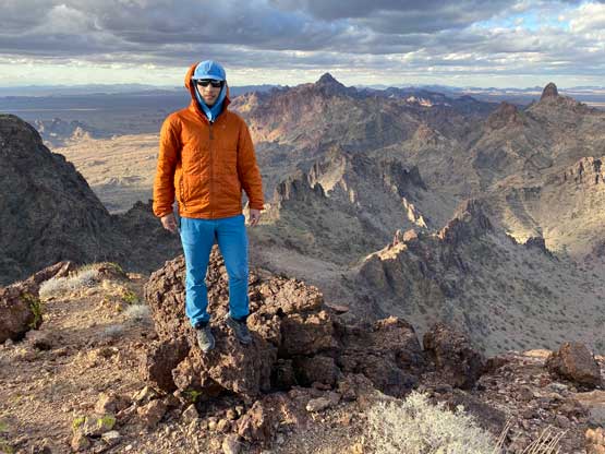
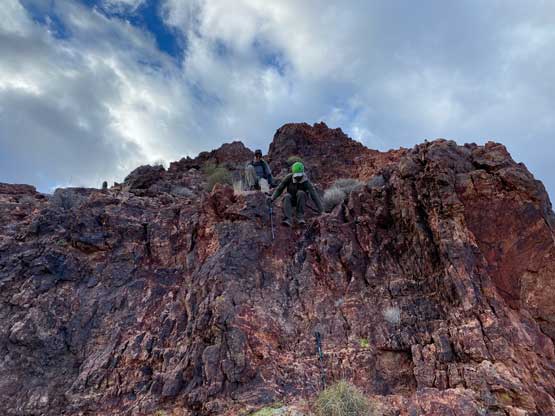
After getting onto the NE Ridge we soon realized that the scrambling was again, harder than expected with complicated route-finding on micro-terrain. The ridge was very broken with towers so we had to traverse on the south side for a while, dealing with a greater deal of loose rocks. At some point we had to regain the ridge so we scrambled a series of class 3 steps towards a higher notch. Continuing scrambling on the ridge from that notch appeared to be class 4, so I backtracked and down-climbed to the north side of the notch (exposed 3rd class) and found a nicer ledge to bypass the rest of the jagged towers. The others followed me to this ledge and we soon made to the uppermost east ridge. From here to the summit we no longer had route-finding challenges but we did have to scramble another tricky 3rd class step. Adam and Matthias kept saying that this peak should not appear on their secret “desert fun peaks” list. I could not comment since I’m not familiar with the rest of that list, but I did agree that the scrambling quality was not great, but on the other hand the views and the route-finding challenges still made this a worthwhile objective.
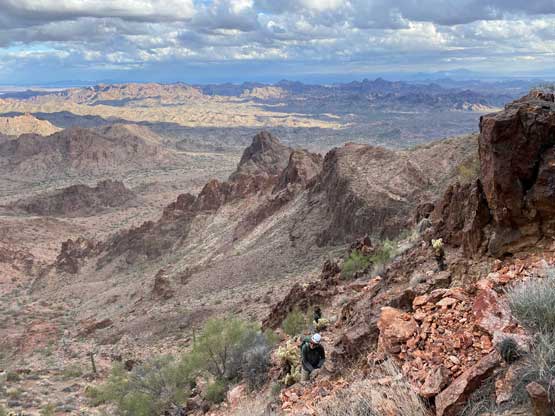


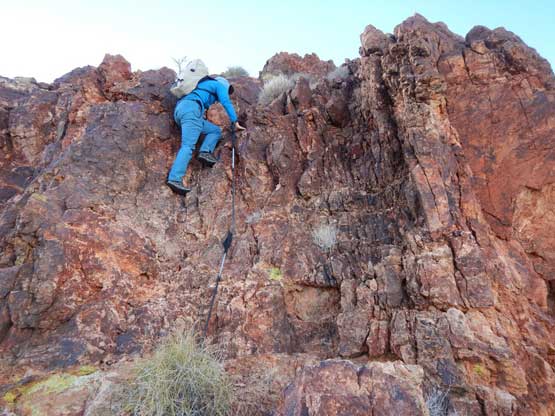


None of us seemed stoked to down-climb the route we just came up from but if that’s the only option then we had to. I spent a few minutes to match what I was seeing to the satellite and topo maps and decided to check out a potential alternative descent on the NW side of the summit. A few minutes later I concluded that it’s definitely doable and would get us to bypass all of the class 3 towers so down we went. We did have to down-climb that uppermost 3rd class step but immediately after that we made a side-hill traverse due SW towards another notch. This notch was not as sharp as the ones on the NE Ridge. From there the descent off the NW Face was very steep on mostly loose footings but did not involve anything worse than class 2 scrambling. Eventually we merged into a wash but the hike-out from this wash was long and tedious with a greater deal with bushwhacking. I was not yet used to the catclaws so I got quite a few scratches, but overall I think we did find a faster route to get off this mountain. If one aims for the easiest way to summit Thumb Peak then our descent route would be the one, but our ascent route was considerably more fun with a greater variety of terrain and scrambling.


The challenge of this objective was not over yet as Matthias must drive us back out of that stupidly rough Big Eye Mine Road. At least now we no longer had to deal with the unknowns and we just had to be patient. Eventually after about 2 hours we got back to Adam’s Subaru and it was already dark. We decided to cook dinner right in that spot and then drive towards our next objective, Clifty Benchmark to set up camp somewhere there.

