Little Ring
April 23, 2022
2147m
Pemberton Icecap, BC
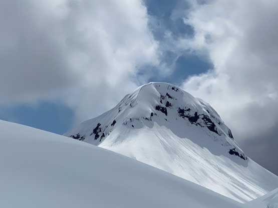
“Little Ring” is a rugged volcanic plug guarding the vast Pemby Icecap on the southern edge. This peak does not really stand out from the surroundings by elevation, but the steep profile makes it one of the more recognizable summits in the region. “Little Ring” is much more remote and difficult than Ring Mountain which is just a standard day-trip scramble from Whistler. This little peak is however, rarely attempted and among those few trip reports on the internet, there are more failures than successes. The standard access is a bushwhack from the head of Squamish River valley which requires about 60 km or more driving on a logging road. The east ridge seems to be the only documented route on the internet. A cornice is usually blocked the direct finish, turning back those who did not come here prepared for a steep snow and mountaineering ascent. A rope is likely needed for most parties.
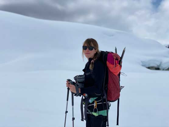
I had been considering “Little Ring” for a number of years and my plan was to go via Squamish River valley in June, which seemed like the “standard time”. However, about one week ago I came across another possibility and I was quickly sold. Eric G. and I were snowmobiling and ski touring on the Pemcap from Rutherford Creek and bagged 4 peaks including “Torah Peak” which was really not that far from “Little Ring”. We saw loads of snowmobiles out there including two of them doing a Rutherford-to-Brandywine traverse. “Little Ring” was on that traverse line, so with a bit more fuel and more companions (safety wise) we should be able to snowmobile all the way to the base of this peak, saving that uncertain drive up the Squamish Valley and the associated bushwhacking/creek crossing unpleasantness. The weather forecast for the weekend after was decent enough to pull the trigger and this time we decided to just day-trip the icecap. Eric, Elise, Derek and I sledded all the way to the main bulk of the icefield and ascended “Conscience Peak” earlier in the morning. The weather was not as good as expected that we were in some intermittent white-outs. While backtracking from “Conscience Peak” we eventually descended through the cloud layers but the light was very flat and there was no existing snowmobile tracks to follow. However, the navigation at this stage was not complicated so we carried on towards “Little Ring”, another few dozen kilometers to the south.
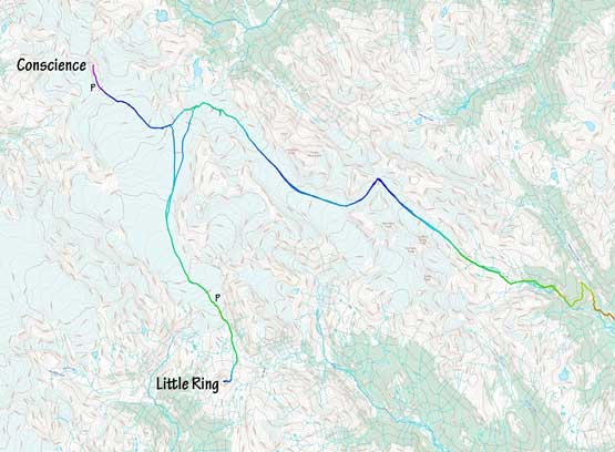
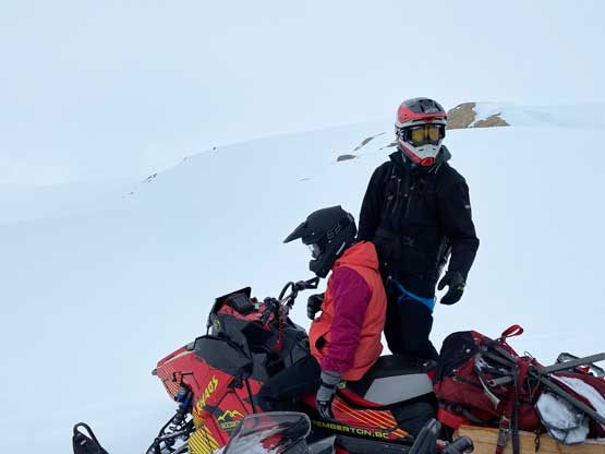
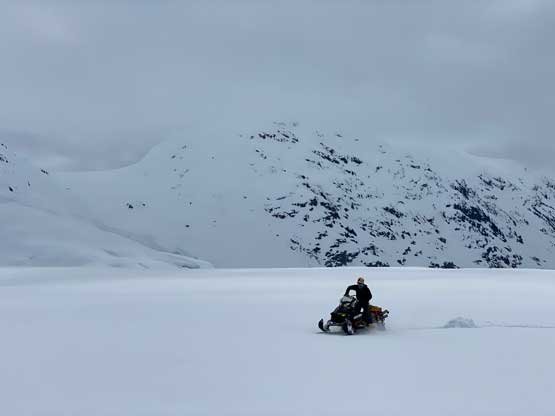
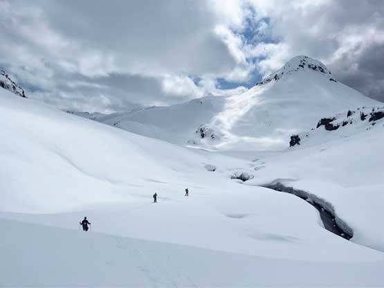
Derek and Eric took turn breaking trail on the vast icefield. The snowmobile sounded easy in theory as we just needed to cruise on the flat ground, but whenever Eric and I went ahead we knew it wasn’t nearly that straightforward when we couldn’t see any of the terrain immediate ahead. Patience was the key and we also needed to stop numerous times to check the GPS to make sure our bearing was correct. Eventually we sledded past “Numbers Peak” and started the descent towards the toe of this gigantic glacier. On my downloaded satellite images I could not see this glacial toe being more complicated than what we had just done on the Appa and Longspur sides, but we could definitely see crevasses and obvious sagging around. We pushed another 1 km or so on the sleds and eventually called it. We were about 1 km from the end of the glacier and that was well within walkable range, so we shouldn’t risk falling into those crevasses on the snowmobiles. The snowmobile-to-ski transition took a while and the descent to the glacial toe was indeed harder than expected with lots of micro-terrain to navigate around. There were ice cliffs at the bottom that weren’t quite visible from above (especially in flat light) but we threaded a line to make a smooth descent. After that Eric and I had to put the skins on and meanwhile Derek and Elise caught up with us on snowshoes.

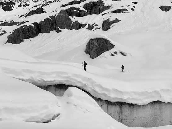
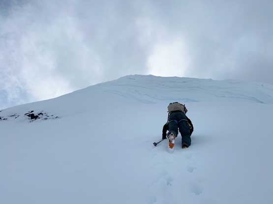
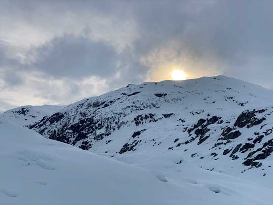
The four of us then plodded upwards into the narrow valley immediately on the SW side of “Numbers Peak” that involved one gradual ascent followed by a long stretch of flat terrain. Our objective, “Little Ring” was finally visible again and looked quite fancy and impressive. The NE Ridge seemed to offer a very steep, but continuous snow-climbing option in the spring conditions with loads of snow, but after some discussion we decided to stick to the “standard route”. The views were deceiving. Even though the peak looked rather closely we had to ascend 800 m just to reach the east ridge and that wasn’t a simple task. The snow conditions were frustratingly wet and heavy and the light was mostly flat. I started to get dizzy from the disorienting lighting so Eric soon took over the lead. Eric and I then took turn breaking trail all the way to the base of the climb. It was a long haul that necessitated one energy break in the middle.


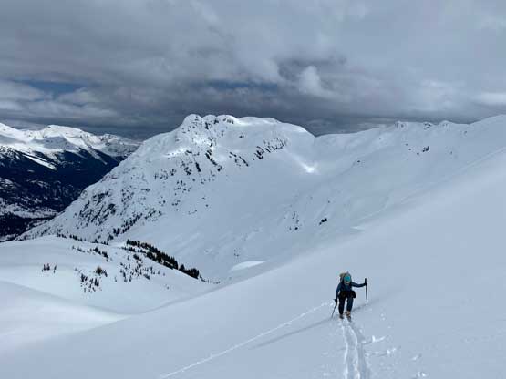
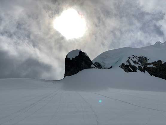
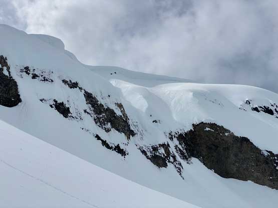
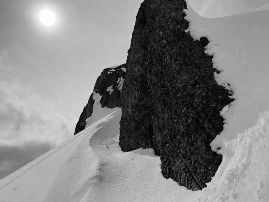
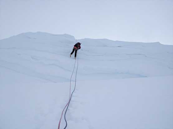
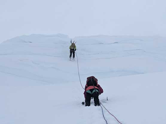
We eventually ditched skis and snowshoes on the south (climber’s left) side of an obvious rocky buttress. From our approach this buttress looked to be difficult to surmount, but it’s easy on the opposite (south) side. We then boot-packed and traversed a long ways on mostly 35 degrees snow on the south side of the east ridge until we were directly underneath the summit block where some massive cornices were guarding the top. The obvious snow ramp to the far left seemed like an viable option to bypass the cornice but the exposure and the steepness was daunting. Nonetheless we marched up, now with Eric leading the increasingly steep slope to directly underneath the cornice. The slope angle maxed out to around 45 degrees in this stretch and the snow condition was excellent for step-kicking.


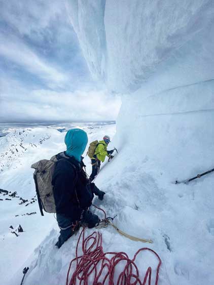
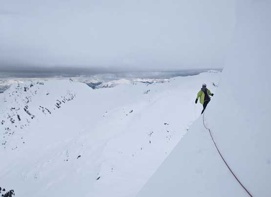
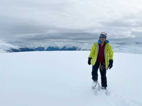
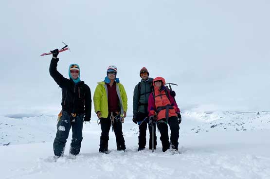
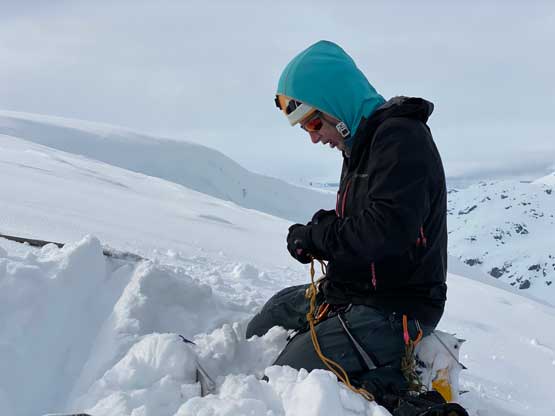
The slope angle on the planned traverse ramp was as expected, 55-60 degrees if not more and we knew there’s a cornice above and cliffs underneath. Eric and I formulated a plan and we immediately started building a snow anchor as nobody wanted to linger any longer than necessary underneath these house-sized cornices. I then led the way out climber’s left using two ice axes for about 20 meters. Among the four of us there was only one snow picket which I needed to build the upper belay station so the only option for me to put in an intermediate pro was to leave one of my ice axes fixed into the snow. After seeing the rest of the route beyond the cornice lip was a “go” I hammered my Camp Corsa alunimum ice into the slope and led the rest of the way using a single ice tool. I then built a dead-man anchor, backed it up with another dead-man using my ice tool and fixed the rope in, but then the communication had become extremely difficult. I figured they would eventually start climbing as they knew it wouldn’t take me that long to fix the rope, and sure enough after about 10 minutes Derek showed up so I knew everything was alright down there. I then rappelled off the rope back to that intermediate pro until I could see Elise and Eric mostly to facilitate the communication. Elise’s job was to climb the whole pitch while attached to the fixed rope through a micro traction device. I then belayed Eric in two pitches (one traverse, one straight up) and it didn’t take too long for the four of us to top out onto the summit. We wondered around a bit to make sure we tagged the highest point. Eric even brought his sight-level thing for a more precise measurement so that we knew which lump of snow was the true highest point.


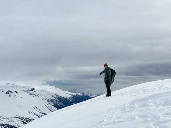
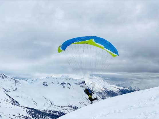
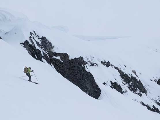
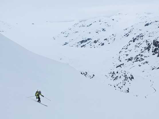
The position for the snow anchor wasn’t ideal for the rappel so I dug the picket out and meanwhile Eric dug out another t-slot about 10 meters to the north. At the same time Derek was preparing for his paragliding and I needed to eat some food as I was getting hungry. Derek and Eric took off on their respective descent at about the same time. Elise followed. I dug out the two additional ice axes and rappelled off the single picket anchor. The three of us then down-climbed to the ditched skis and snowshoes. The skiing was difficult in the flat light conditions but I did manage to make some turns here and there. The snow conditions were also horrible for skiing but whatever. Eventually I managed to descend this entire 800-m slope on skis with only two falls. Derek was already back at the sleds and started sledding towards us. Being a much more experienced snowmobiler it didn’t take him long to sled partway up Little Ring to grab Elise so I eventually became the slowest person to get back to the sleds. Wasting no time the four of us started the long journey back out. At this point we only had a little over half an hour’s daylight so we must hurry up. Darkness eventually fell as we descended onto Appa Glacier. The weather was also not cooperating as we again descended into some intermittent white-outs but thankfully the white-outs didn’t last too long. We then had a scenic descent down the rest of Appa Glacier in the fading daylight. The ride from there back to the cabin was a wild one mostly on whumps with some stretches of side-hilling and of course Eric and I rolled the backpacks off one more time. The fuel gauge was acting constantly so we just poured the 2.5 extra gallons of spare fuel into the tank. The Rutherford FSR was extremely whumpy and was definitely not very pleasant to ride on. My arms and upper body was still sore even 2 days afterr the trip.


We eventually got out about an hour into dark and three of us needed to get to our respective home. Elise, Derek and I took off immediately after loading our stuffs and in about an hour and half we were back to Squamish. We were glad that McDonald’s wasn’t the only restaurant open so we went to A&W for some burgers. I eventually got back to White Rock at 1:30 am and Eric did not get back to Seattle until 4 am in the morning.

