Banded Peak
October 11, 2020
2934m
Elbow River / Kananaskis Country, AB
Banded Peak is a rather iconic summit in the front ranges of Kananaskis highly recognizable from Calgary. The name was derived from an obvious rock band near the top but in my honest opinion the “proper” name should be “Nipple Peak” as to me, it looks like a nipple from literally anywhere I see it… Contrary to its iconic and well-known status the standard route is rather just a long slog on rubble and scree and is well written in Alan Kane’s Scrambles in the Canadian Rockies as well as various online trip reports. For ambitious peak-baggers this peak should be done as part of the Glasgow to Banded Traverse as it simply makes sense to connect the four peaks in one grab, and that’s exactly how Winnie and I did it. We made a long ass drive from Vancouver to the front ranges of Rockies on Saturday to escape the dreary weather of the coast, and on Sunday we had just made ascents of Mt. Glasgow, Mt. Cornwall and Outlaw Peak.

Glasgow to Banded Traverse route. GPX DL
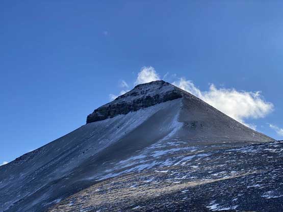
From Outlaw/Banded col the ascent of Banded Peak was nothing but a few hundred vertical meters of slog on scree. After a while we somehow picked up some game paths here and there but the winds picked up again. The summit was reached earlier than I thought and the views weren’t as good as from Outlaw Peak. And again because of the wind we didn’t get to stay on the summit for any longer than absolutely necessary.
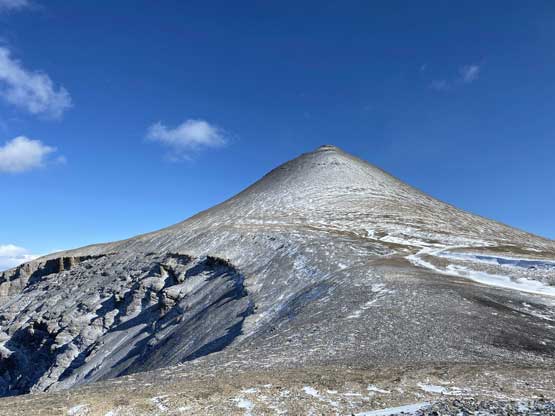
Banded Peak from Outlaw/Banded col

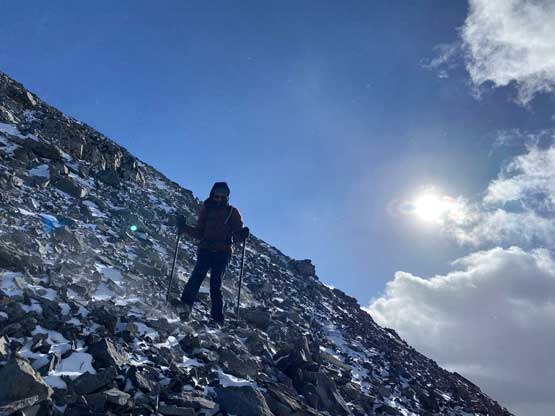
Winnie slogging up Banded Peak with Outlaw Peak behind
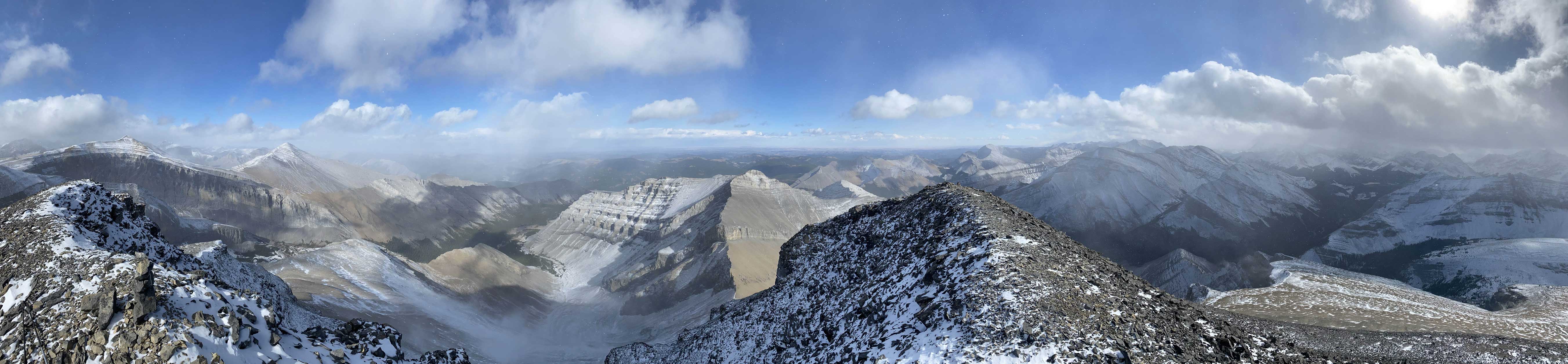
Partial Summit Panorama from Banded Peak. Click to view large size.

Partial Summit Panorama from Banded Peak. Click to view large size.

Me on the summit of Banded Peak

Another photo of me on the summit of Banded Peak
None of us did much research about the descent and all we had was Matt Clay’s GPS track and memories from reading his and a few other trip reports. We followed the GPS track descending the north ridge which was pretty easy going until at some point we had to veer skier’s right onto some steeper slopes. Winnie remembered something about “getting cliffed out” from Matt’s trip report and mentioned that to me so that I could pay closer attention in the route-finding. I of course, did not read his trip report and rather just downloaded the GPS track. With Winnie’s words in mind I figured out where Matt went wrong and didn’t make that mistake, but then we still had to descend a few hundred meters of very shitty rubble and scree. The descent from there downward to the valley between Mt. Cornwall and Banded Peak was quite painful but went by fairly quickly.
Winnie descending the uppermost north ridge of Banded Peak
Another photo of Outlaw Peak

The typical descent

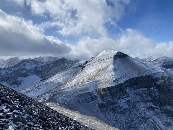
Mt. Cornwall and Mt. Glasgow that we bagged earlier in the day

Winnie continuing down Banded Peak’s N. Ridge
Looking back at the obvious “band” on Banded Peak

Interesting rock formation on Banded Peak’s outlier
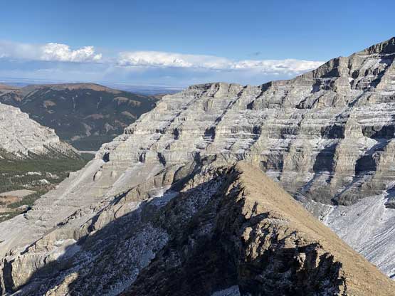
This is rather just some typical Rockies front ranges scenery

A zoomed-in view of Mt. Glasgow

This section of the descent into the valley was pretty shitty

After a while we got down in the valley
We weren’t quite sure whether we should stay on the north or south side of the creek but we figured if there’s a trail it must be on the north side, so hopped across the creek and re-ascended onto the bank. We did not discover any form of a “trail” however so we just followed Matt’s GPS track into the forest and did about a kilometer of “BW2” bushwhack. The bushwhack brought us to another large open and flat area and on the far side of that opening we picked up the horse trail. This horse trail was in a surprisingly good shape that we had no problem following it all the way out to the Big Elbow Trail. The game’s not over yet as we still had well over an hour’s slog on the main trail/road. The last few kilometers were done with head-lamps on, and our round trip time was about 12.5 hours.

Re-ascending a bit to get onto the bank on the north side of the creek

Some pointy highpoints from the valley between Mt. Cornwall and Banded Peak
We evaluated our time and position and decided against driving anywhere. We took our time cooking a late dinner at the parking lot and leisurely set up the tent for another night of car-camp. It snowed quite hard through the night that by the time we woke up at around 8 am the car and the tent’s already covered by a thick layer of (wet) snow. Packing the wet sleeping bags and wet tent proved to be very miserable. We didn’t manage to start driving until 9:30 am. The drive eastwards to Bragg Creek then onto Highway 1 and westwards back into the Rockies was done in some snowy and rainy weather with minimal visibility. We did a gas stop in Canmore, two tourists stops at Lake Louise and then Natural Bridge in Yoho, then a (late) lunch stop in Golden before pushing back into the interior BC. The rest of the drive back home was exhausting but at least I was on the familiar ground, and that concluded another successful Rockies trip.

I left my shoes outside overnight.. Not the smartest idea…

Our first tourist stop was Lake Louise…

Our second tourist stop was in Yoho, in rain…

Our third tourist stop was at Rogers Pass for a photo of Mt. MacDonald
