Mount Judge Howay
June 20-21, 2020
2262m
Stave River / Golden Ears Provincial Park, BC
The double-summit massif of Mt. Judge Howay dominates the very southern stretch of Coast Mountains and is extremely recognizable from hundreds of summits I’ve attained. This peak doesn’t need to be introduced thoroughly. While it’s not a major allure to foreign or even the Rockies climbers it is by no doubt one of the most important, if not the single most important summit for peak-baggers based in the Lower Mainland of British Columbia. For those that have experienced the southern Coast Mountains I’m sure to climb “The Judge” is on their dream. However, the success rate is extremely low with one party per several years in the past decade. While the climb is essentially non-technical either in June on steep snow, or in late summer on rock, the approach bushwhack and the logistics to cross Stave Lake and Stave River has made Mt. Judge Howay an extremely difficult summit to access. The lake is large enough that it can create ocean-sized waves without a warning and the river is fordable on foot only on the very strict timing windows of a year. Between the lake and the river there are 14 kilometers of walking on logging roads that can be biked. And between the river and the bivy at 1200 m one needs to fight against “BW4” bushwhack on extremely steep and bluffy terrain. And to make things more interesting, one needs to climb 45+ degree snow (in June) or 4th class rock with tricky route-finding and snow-to-rock transitions (in late summer), that even if one makes to the alpine it’s still not guaranteed.
Alex and I had been talking about Mt. Judge Howay for several years and this was the year that we finally pulled the trigger. The stupid Covid thing had kept me in bay in our local areas so I had plenty of time to play the waiting and timing game. We agreed to pulled the trigger as soon as a favorable window showed up starting from mid May bailing any other commitments including work, because steep snow was certainly our expertise compared with climbing rock. The problem was the weather. We had no single sunny stretch that lasted for more than 1 day since our trip to Mt. Neal area behind Wedge Mountain, so the waiting game was almost two months long. Quite a few friends managed to get on board but had to bail once we decided to postpone. I have to admit it was a somewhat frustrating process trying to manage to team, but that’s it for any big-mountain expedition. The effort behind the scene on one’s computer is no less than the execution of the trip. Eventually at the summer solstice we finally decided to take a gamble even though the weather window wasn’t 100%. We pulled the trigger at literally the last possible minute and it was Vlad, Dean and Winnie boarding the game.
Meanwhile we had studied literally every single possible method to cross the lake and the river while talking to literally tens of people including logging company, 4×4 enthusiasts for the few logging roads on either side of the lake, and climbers who had successfully climbed this peak (in particular, Jeff Han), and those that could give us mechanical support, either privately or by commercial means. We ruled out the option to cross the lake by means of self-propelling because none of us is experienced in canoeing. To combine our weeks of research the decision wasn’t difficult to make, but for the sake of security reasons I am not allowed to write about our approach. This trip report starts from our camp at 1200 m elevation and only includes the summit day.
[I would really love to tell the world how we got to that 1200 m camp as that involved 2 months of timing and coordination with people, and hours spent studying maps and photos to death to find that spot where we camped. Then the way in was also a wild and unforgettable journey that would be very cool to share. But when I meant “security reason” I meant seriously.. If I wrote it clearly in this trip report that could potentially put us in trouble so I cannot.. But if you are my friend in person then the chances are I’ve already told you the tale.]
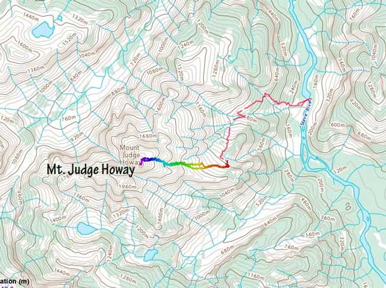
Mt. Judge Howay standard route. GPX DL (Only 1200m onward)
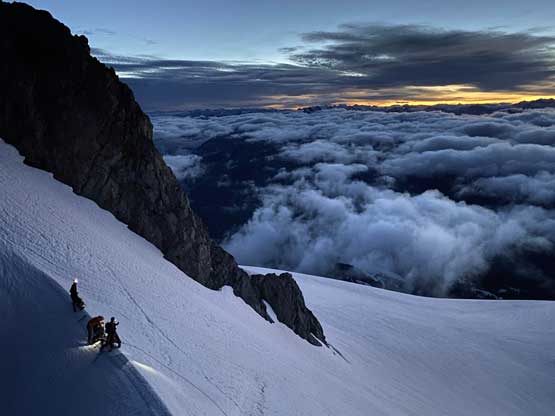
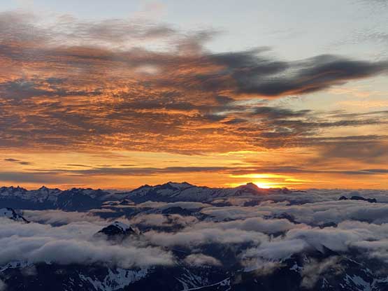
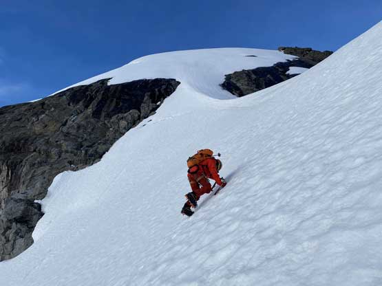
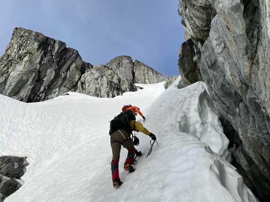
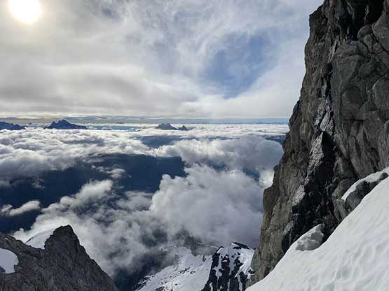
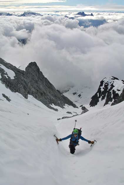
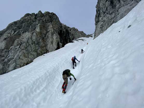
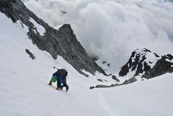
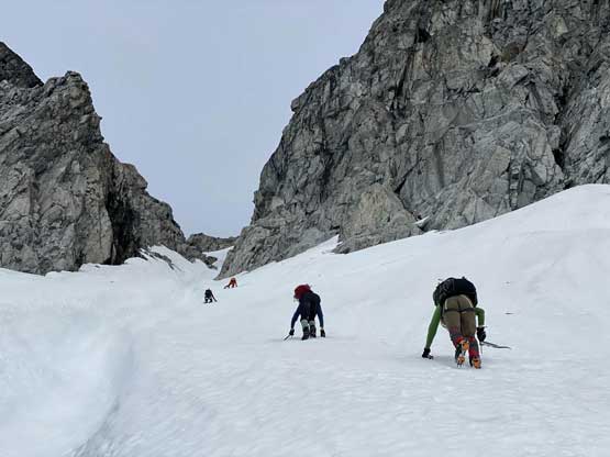
The forecasted freezing level was well over 3500 m but the night was supposed to be clear, so we were still expecting some degree of freeze. But to take the most use of the frozen snow we decided to wake up at 12:30 am and go at just after 1 am so to give us about 4 hours of climbing before sunrise. I did not get any sleep unfortunately but once the time’s up it’s still pretty easy to fire up the stoke level. The initial few hundred meters of elevation gain was on gentle terrain and the weather was humid and foggy. After a while we broke through the low clouds. The valley leading up towards the “hourglass” had a few twists and turns that GPS navigation was important to stay on the route, and the terrain did not steepen up until pretty much 100 vertical meters under the hourglass. We encountered a rock band with a moat, took one last break and committed to the climber’s right side bypass and soon started front-pointing onto 40-45 degree snow. The ice tool came out in no time. We climbed the climber’s right side of a huge runnel but had to climb into the runnel at just under the constraint. The runnel was super fun and cruising with a few steep steps. The crux was however, a bit melted out that we had to climb a short, but 60+ degree snow step on the climber’s right side of the fall line. This was a bit sketchy and we agreed to rappel it on the descent instead of down-climbing. Above the hourglass constraint the terrain laid back a little bit but soon became 45 degrees again. The condition was again, entirely front-pointing. I led a line up the climber’s left side of a rock island feature and then diagonally traversed right aiming for the high col. The snowfield leading up to the col dragged on for a long while.
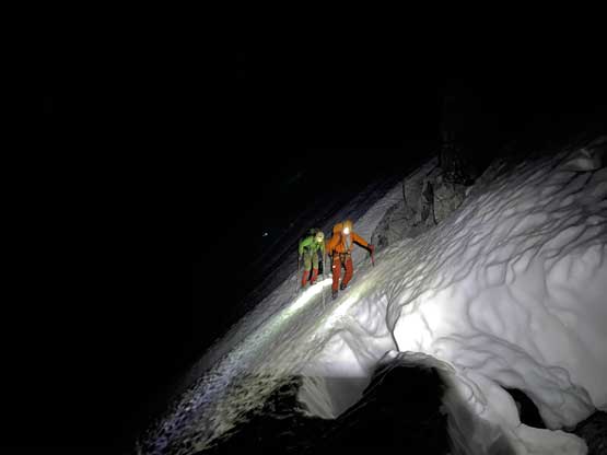
Encountering a rock band and a big moat. Traversing right onto steep terrain

Winnie front-pointing up the gigantic runnel leading into the hourglass
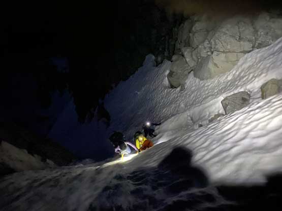
Climbing the 60+ degree step in the hourglass. Crux of the climb

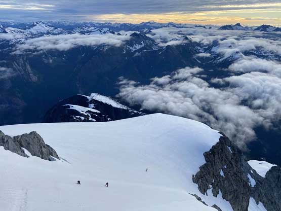
Dean and Winnie traversing the upper snowfield towards the col
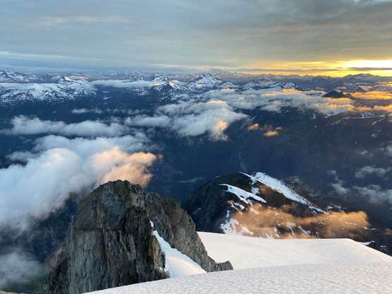
Our group resting at the col with the sub-summit behind
The north-eastern horizon showing some morning colours.
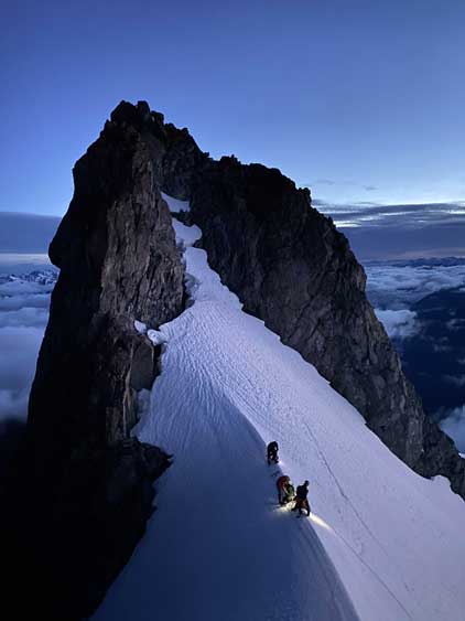
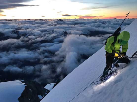
The pitch to the summit looked insanely steep but I knew it was only 45 degrees based on what Jeff told me. At this point we were still an hour away till sunrise and everybody’s tired, so we decided to take the rope out and set up a belay. We only had two 30 m ropes and the pitch definitely looked more than a pitch long, so we tied the two ropes together making it a 60 m one. I swapped my mountaineering ice axe for a second ice tool and went ahead dragging the rope up. I didn’t feel the need to be belayed and indeed, the slope angle eased off once I was actually on it. The snow condition was also bucket step-kicking instead of front pointing. I ran a full 60 m pitch but was still at least 10 m away from the summit so to make it safe I decided to build an anchor using one deadman and one vertical picket. Alex and Vlad soloed up to the summit while I belayed Winnie and Dean to the station. I then belayed them to the top as if they were leading and soon all of us were on the summit. There was still 20 minutes to the sunrise so we earned ourselves plenty of time taking photos. The clouds were incredible and the sunrise was definitely one of the best I’ve seen.

Me leading the summit pitch. It’s not as steep as it looks here. Photo by Winnie M.

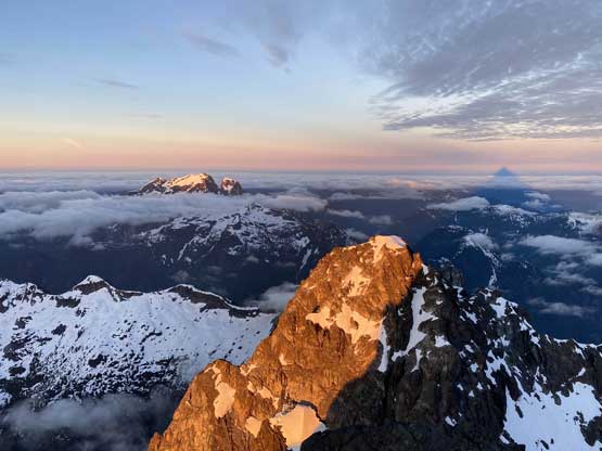
Alex soloing up the pitch with the sub-summit behind
Me doing some rope work. Too bad a 60m pitch doesn’t reach the top
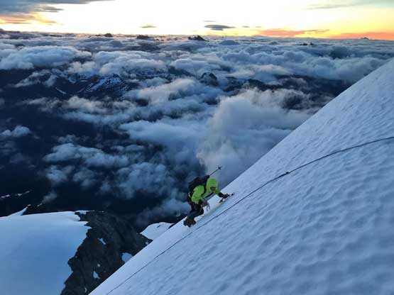
Me taking the rear end climbing to the summit. Photo by Alex R.

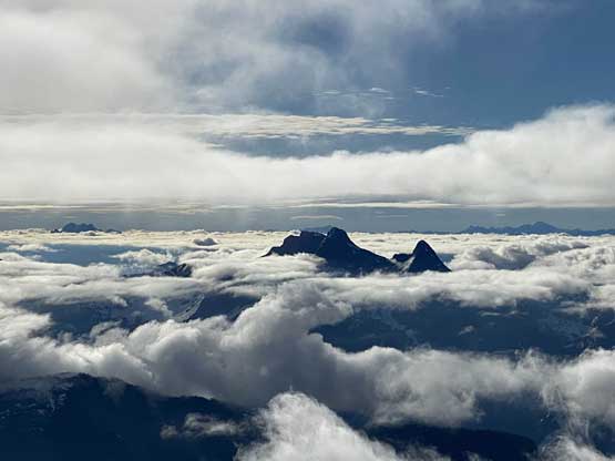
The remote area around Cairn Needle
Stave River is visible more than 2000 vertical meters down

Robertson Peak at center foreground with the morning sky
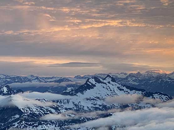
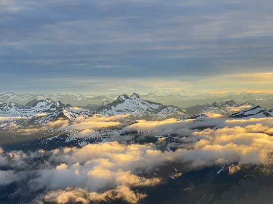
It’s almost sunrise time. Looking at Mt. Breakenridge and Traverse Peak
Mt. Ratney barely poked above the low clouds, in the foreground

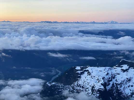
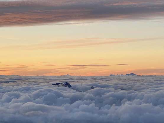
A wider view looking north-east showing more of the morning fog
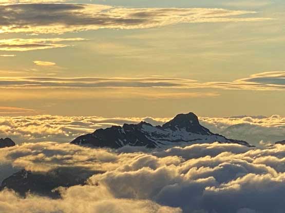
A closer look at Robertson Peak, an “ultra” that’s been climbed only 3 times

A closer look at Cairn Needle that probably has seen only 1-2 ascents…

Traverse Peak is been climbed more often but still very remote

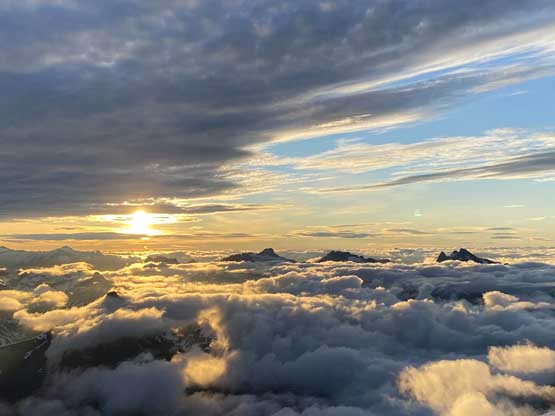
Now it’s official sunrise, behind the shoulder of Mt. Breakenridge

Winnie on the summit of Mt. Judge Howay, her first steep snow climb…

Dean and Alex on the summit
The lower SW summit in the foreground

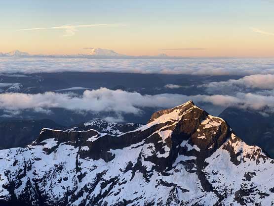
Mt. Judge Howay catching a giant shadow like a volcano…

The tip of Mt. Robie Reid poking above the clouds. I climbed that one in a white-out

The Defendant in the foreground – climbed only once by the one-and-only John Clarke
This is looking down at the sub-summit and the upper snowfield
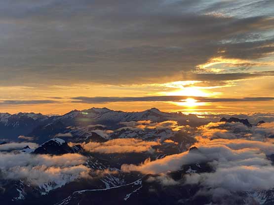
Yet another photo of the sunrise behind Mt. Breakenridge

Vlad taking in the views
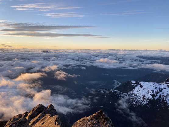
A wider view looking south. The clouds were lifting showing more of the Stave River valley
Mt. Kranrod in the foreground. Probably hasn’t seen many ascents neither…

Yet another photo of the giant shadow of Mt. Judge Howay

A closer look at Mt. Robie Reid

Another photo of Vlad taking in the views
Vlad and I with the SW peak and the shadow behind

Now it’s “golden glow” time…
A closer look at the morning sun behind the Chehalis Group of peaks
Robertson Peak again…

Traverse Peak and Mt. Breakenridge again

Mt. Clarke with Recourse Peak and Viennese Peak attached on left
Grainger Peak that I bagged a few weeks ago…
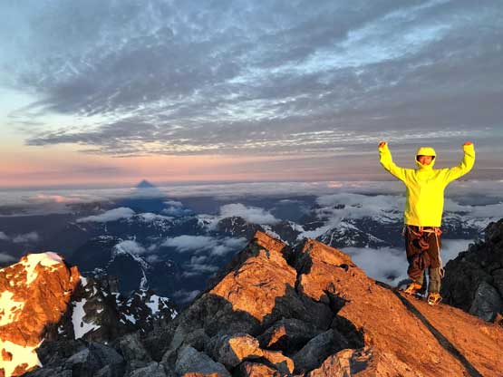
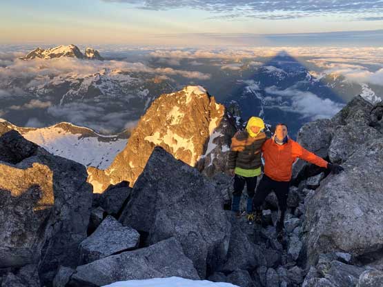
Me on the summit of Mt. Judge Howay

Our group shot on the summit of Mt. Judge Howay
There was a layer of high clouds rolling in blocking the sun so we figured there’s no point in lingering too long up there. On the descent a few of us rappelled the summit pitch on that single, 60 m strand. I took the rear end, digging out the pickets, down-climbed the pitch and we all regrouped on the snowfield below the col. We decided to stay skier’s left side of that rock island to avoid crossing into and out of the icy runnel. There’s one steep (45 degree) roll and indeed, it turned out to be an easier route to get into the hourglass constraint. At the crux step we wrap the rope around an obvious snow bollard on the moat’s lip backed up with a deadman picket. Four of us went down first and Dean took the rear end taking down the picket so we didn’t leave anything behind. The down-climbing inside the gigantic runnel below the crux was super aesthetic. I was debating to just keep down-climbing inside the runnel but opted for the known, traversing out of the runnel towards skier’s left to join our uptracks. Then more down-climbing facing into the slope on softening snow saw us descending out of the steep zone in a timely manner. The rest of the return back to camp was pretty easy that we got back by 8:50 am…

Dean down-climbing into our rappel station

Winnie rappelling while Vlad and Alex’s at the col

Looking back at Dean rappelling the summit pitch. Photo by Winnie M.
Alex, Vlad and Winnie down-climbing the upper snowfield

Another photo of the upper snowfield from the col

The western view from the col.
Dean dropping onto the upper snowfield

Winnie and Dean down-climbing the snowfield

We took a different line down the upper mountain
Back to the hourglass
A sideways view from the hourglass.

Winnie and Vlad at the rappel station. Photo by Dean P.

Vlad rappelling. Photo by Dean P.

Alex rappelling
Mt. Ratney and Stonerabbit Peak finally showed up
Me down-climbing the runnel. Photo by Alex R.
Our group down-climbing the runnel.
Me traversing out of the runnel onto more 45 degree snow. Photo by Alex R.
Down-climbing 45 degree snow under the hourglass constraint

Walking now…

Vlad descending the hanging valley back to camp

Our tents on the only flat spot we could find in this entire 1100-1200 zone…

Looking back at Mt. Judge Howay now engulfed in clouds
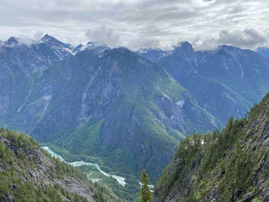
Very rugged terrain looking down into Stave River valley

A closer look at Stave River. Would require a canoe or a packraft to cross.
This was once again, a uber successful trip that proved that good ol’ words of “timing is everything”, and to make the perfect timing one needs commitment. To make this trip happen Alex and I were basically on-call for the climb as soon as a window formed no matter what days it’d be. We also had quite a few other friends that made the call to join, but when it actually happened it came down to who could ditch work and other stuffs at the very last minute. Now I’m also glad that we no longer need to check weather forecast every three hours or so and look at those clouds wondering if we could ever get there. Thank Alex, Vlad, Dean and Winnie big times for making this one happen.
