Haner/Whacme Mountain
May 29, 2022
941m
Bellingham, WA
This broad forested plateau sandwiched between Acme and Lake Whatcom has two unofficial names, “Haner Mountain” and “Whacme Mountain”. The website peakbagger.com registers it as the former but Summit Post says the latter is actually more commonly used among prominence-oriented peak-baggers. The second name makes more sense for me as it combines Whatcom with Acme into one word. This summit is on the southern half of the plateau but two summits of “Bigfoot Hill” about 10 km to the north share basically the same elevation and it’s impossible to tell which of the three is the highest. To safely claim the prominence of this peak (over 800 m) the general consensus is that one must ascend all three peaks. While the other two peaks can be combined fairly easily into one outing from the east side, “Haner/Whacme Mtn.” is best done separately from the west. This area is riddled with (gated) logging roads and biking trails so using a bike was the only method I was keen on.
I made the spontaneous decision at noon on Sunday. I finished the day at 12 pm as my afternoon work got cancelled at the very last minute. I had not checked the weather forecast yet but the sky was clear in White Rock so I assumed the foothills in the vicinity of Bellingham would be similar. Indeed, the forecast was calling for 0% chance of precipitation throughout the afternoon and evening. I figured that the ascent of this peak wouldn’t take more than 4 hours so there’s no need to rush. Firstly I went to a local restaurant to having a proper meal, and went home to finish writing the Yalakom Mountain’s trip report, which took a couple hours. I did not cross the border until 5 pm and subsequently did not start the ride until 5:30 pm. In retrospect I should have rushed a little bit in the afternoon as I barely managed to get down before dark and having to use head-lamps on a downhill mountain biking trail is not a smart idea.
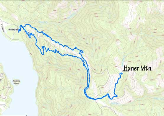
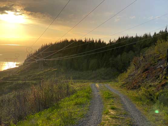
I consulted with Matt J. about the best uphill and downhill routes as I knew nothing about the biking trails in the area. Instead of pedalling up the steep road I opted to take Chanterelle Trail which had been designed for uphill biking. The switchbacks were long and unnecessary for hiking purpose but they were awesome for biking. Even I managed to pedal most of the way up. A couple kilometers later I popped out on a stretch of flat logging roads that led me to a substantial viewpoint. Two other hikers were there so I managed to get a picture of myself.


The trail beyond the viewpoint were steeper and narrower such that I had to get off the bike several times to push. The riding was still mostly within my ability so I tried pretty hard to pedal most of the way up. The trail was unfortunately muddy and slippery but the fat tires were built for mud so that’s not a problem. The grade of the upper sections of Chanterelle Trail was quite mellow with some up-and-downs. I popped onto the logging road at the end of this trail and easily cruised a few more kilometers on mostly flat grade to Haner Mountain’s south side spur. Somewhere along this stretch I popped into a black bear blocking my route. I yelled and the bear yielded. The final spur was steep and loose such that I had to push more than half of the way up. The very summit was located in some dense secondary growth forest but thankfully the bushwhacking was very short-lived. It’s difficult to tell where exactly is the true highest point so I wondered in the thick bush for quite a bit just to be sure.


While riding down the uppermost spur I came across that bear again and this time he yielded before I even noticed his presence. It was then a cruise sail down the flat and then slightly-downhill FSR. Instead of riding all the way down to the bottom I opted to take the “Brown Pow” mtb trail down, which was definitely more challenging than expected. First of all I had to gain at least 30 m to top out onto a ridge. There were lots of blow out sections in addition to numerous up-and-downs that I had to get off the bike and push. At least two jumps and at least 10 stretches of insanely steep grades with unknown bottom made me to get off the bike as well. But I did tried hard to ride down anything that I felt decently safe to do so. The lighting was not great at all as I was descending near and after sunset. I took a massive spill flipping forward over the bike’s handle near the very bottom of the trail. It took me a few minutes to recollect myself but after standing up I realized no bone was broken, so I continued riding. Ironically there was no more difficult section after that. I did one stop on the way home to get some cheap Washington gas. The border had no delay this time and I got home at 10:30 pm. I debated about to just go to sleep but I was hungry so cooked a very late dinner.