Sugarloaf Mountain, Tomato Hill, Tucker Hill, Kirk Hill (FL)
December 10-11, 2022
94m, 51m, 55m, 64m
Orlando, FL
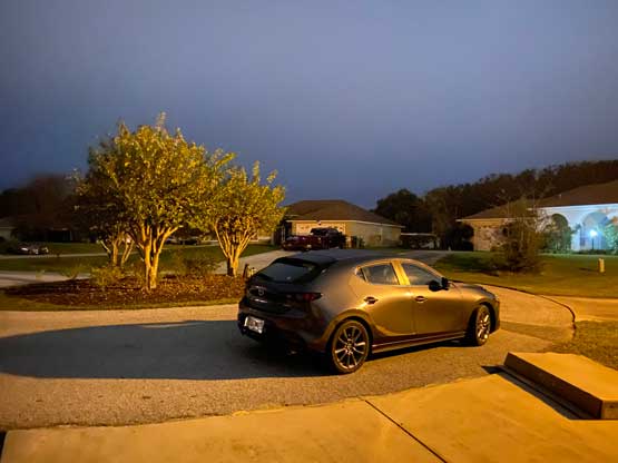
The state of Florida is not known for mountaineering as the entire peninsula is low lands at sea level with the highest point being Britton Hill at 105 m elevation. The state’s high point isn’t even located on the peninsula and is rather on the far NW corner next to Alabama. The highest point on the peninsula is Sugarloaf Mountain at 94 m and believe it or not, this peak actually boasts over 200 miles of isolation making it one of the more isolated peaks on the continent… On my way to Ecuador I happened to have 13 hours of layover in Orlando and then 6 hours of layover in Miami and I naturally went to the maps to search for some peak-bagging potentials. I immediately found this Sugarloaf Mtn. in the broader vicinity of Orlando and subsequently found a few more officially-named pimples. I formulated a plan to rent a vehicle in Orlando. The primary purpose was to fill in this long layover and combing that with peak-bagging seemed like an ideal plan, even though the entire trip would be done in the middle of the night.
I got my bag checked all the way to Quito, Ecuador from YVR, Vancouver but I didn’t fully trust the stuffs in the airport. As the layover was long I figured that I might as well wait at the baggage claim and see if my bags would come out, and not to my surprise my bag actually went out. Had I gone straight to the car rental I would have lost the checked bag in the transitions so it’s a good idea to always plan contingencies. I asked the stuffs and they said that I must carry the bag with me overnight and re-check it in with Delta airline in the morning, so I had no choice but to carry the heavy loads all the way to the car rental (Thrifty). The wait was ridiculous and took about 1.5 hours as apparently this was the only rental company that actually had cars in stock thank to the high demand in this holiday season. After filling in some seemingly lengthy paper work the guy gave me directions towards the cars but the “technology” they used was at least 30 years behind (no maps, no smartphones etc.). I had no way to understand his figurative descriptions so it took me another hour or so to find the cars that were actually located on another terminal. The line-up at the cars were again, ridiculous and at least another hour was spent to drive the car out of the parking garage and what a gong show that was. I also had to pay extras as the highways in Florida were full of tolls so a total of around 130 CND was charged and that was 50% higher than what’s shown on Expedia where I made the reservation. Thankfully the main purpose of this side trip was to kill time so I was able to stay positive throughout the waiting game. It was almost 10 pm when I drove out of the airport and then I went straight to a local restaurant/bar for some much-needed food. I did not want to purchase the expensive dinners in the airport and the 3+ hours of waiting made me extra hungry.
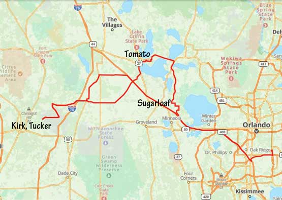
After the dinner I drove straight due NW towards Sugarloaf Mountain, which was the closest objective planned. I had previously downloaded the offline Google Maps as well as the Gaia topo maps so the navigation wasn’t a problem. I had read elsewhere that the true summit of Sugarloaf Mtn. is actually located inside someone’s home but the owner was always kind enough to let the baggers in if they were at home. I had little hope about this since I’d be visiting close to midnight so the plan was to trespass but I would evaluate on scene. I drove to and parked in front their property and evaluated the situation. Directly trespassing seemed rather stupid at midnight as in this state the owners could shoot me straight to death had they seen me acting like a theft so I drove about 20 m to the west that might or might not be outside their property. There was still a fence but I decided to hop across to get a little bit closer to the true summit (which was only 3 m higher than the legal highest point anyway), but a couple meters after hopping the fence I heard dogs were barking so I quickly backed off. I couldn’t risk taking in that few extra meters of elevation gain inside a private property with a possible death penalty had the owner found me, so that’s it. No summit attained. I immediately turned on the engine and drove away as the dogs could very likely wake up the owners and I did not want any encounter with them even though I was already outside the property by this point.

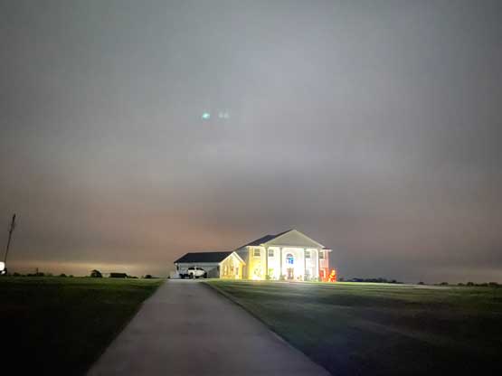
The next objective was Tomato Hill in between Lake Harris and Lake Griffith and the drive there took me about 35 minutes following Google’s direction. This pimple did not seem to involve private property issues as far as my research showed, but the reality was a little bit more complicated than I hoped for. I decided to approach it by driving into the neighbourhood from the south but the northern access might actually be better, in retrospect. Nonetheless I parked the car right in front of a couple houses and walked towards what seemed to me the highest point. This involved walking dangerously close to two residential houses that clearly had people inside (likely sleeping). Even though there wasn’t any sign of “private property” I clearly did not want them to notice my presence. I quickly dashed for the highest point in one of the backyards and ran back to the car. I thought I heart something inside that house so I got very nervous and immediately drove away. This was about 20 minutes before midnight.
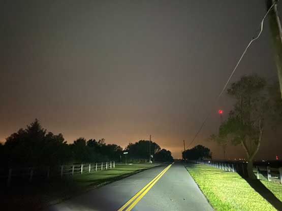
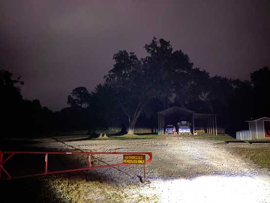
I debated whether or not I should even resume the plan to bag Tucker and Kirk Hills that involved about an hour’s driving towards the opposite direction but I had nothing else to do. The 3 hours of jet lag meant that it would still be early evening in Vancouver time so I couldn’t sleep, nor did I bring a sleeping bag with me anyway. I reluctantly let the technology to direct me to Tucker Hill and made there in about 40 minutes after speeding most of the way. The highways in Florida are in good conditions and there didn’t seem to have many cops out at midnight. This one was the safest of the 4 “peaks” but still, I had to park outside a gate, hop it over and walk dangerously close to someone’s residential house. The light was low enough that I actually had to turn on the head-lamp. There’s a watchtower that I hoped to climb up, but the staircases were fenced off with more aggressive languages related to “private property”. I was planning to climb it nonetheless but the headlamp could well attract the authority to come, so I backed off. I was already standing on the highest ground of Tucker Hill anyway.

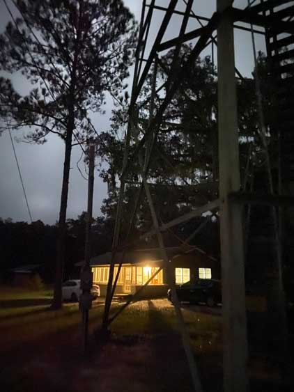
The last objective was Kirk Hill and that’s the worst. This one was only 2 minutes of driving away from Tucker Hill so I might as well try it, and not to my surprise the spur road was gated and clearly inside a farmer’s house and property. This gate was a bit too far away from the true summit to be called “peak enough” so I either had to mark it an “attempt” or to trespass. I turned off the engine and 10 minutes later I decided to find a way to sneak in. I walked about halfway to the highest point (which was right where the house was located) and decided to call it “close enough” there. I could have walked further but I started to worry about dogs. I was about 30 m in and if a dog came out to run at me I would have no escape. I estimated the “true summit” was less than 5 vertical meters higher at this point.
I then drove straight back to the airport about 1.5 hours away with only one stop for gas and some breakfast. I returned the car at 3:30 am and went into the airport to get the bag checked in. I slept during the flight to Miami and didn’t bother to rent another vehicle nor to bag more peaks inside Miami. The “peaks” there were even lamer and I’d rather spend the few more extra hours to rest. This time the bag did not come out of the claim so I knew they were finally checked straight to Quito. The conclusion was to not bother with peakbagging in Florida, period. I probably would eventually need to do Britton Hill but I’m sure that’s my only unfinished business in this state. What a shit show. These peaks are some of the worst I’ve ever done.
