Mauna Kea
February 15, 2023
4205m
Big Island, HI
Mauna Kea, the highest peak in Hawaii, is one of the most significant peaks on Earth. It ranks #8 in isolation and #16 in prominence, and is the tallest peak on Earth by taking in account the underwater portion, rising a whooping 10,000 m above the ocean floor. The only other way of measurement that makes this peak not-so-significant is the elevation from sea level but unfortunately that’s the one that your mom, cats, sisters and co-workers are aware. From climbing perspective Mauna Kea is considered as a “lame” objective that does not attract any mountaineer except for those who also consider themselves as peak-baggers. The easiest option is to drive a 4×4 vehicle to near the summit whereas the other way is to hike the well-defined trail from visitor center, gaining about 1500 m elevation over 10 km distance. Either way there’s no mountaineering involved whatsoever but one still need to treat this hike seriously because of the altitude, the frequent high winds and the cold temperatures.
Nikita, Raphael and I teamed up together at the very last minute to it in the “smash and grab” fashion. The weather in Hawaii isn’t always stable and the way to maximize the chance of success is to book the last minute flights after seeing a solid weather window forming. The window we picked wasn’t bomber but good enough to get the job done. The downside of this “smash and grab” fashion was the elevated cost as we paid several hundred extra dollars each person compared to the cheapest possible way, but that wouldn’t be a problem for us. In terms of the “style” none of us wanted to claim the success by driving to the top so we would be hiking up from the visitor center. In fact, the hike-up option bypasses the authorities and actually gives a higher chance of success because the upper portion of the road is frequently closed due to snow/ice, high winds and low visibilities. Those elements would however not be a show-stopper for us mountaineers. I required everybody to bring enough clothing and gears to give 200% contingencies for the weather and conditions and I basically told them to expect -20C temperature with 40 km/h wind even though I didn’t think it’d be that rough. I myself would bring the same clothing system as I did on Chimborazo – winter parka, gortex pants, long johns, gaitors, ski goggles, balaclava etc. because I wanted 100% chance of success. I had been closely monitoring the weather updates and the week leading to our arrival saw some extremely high winds (over 70 km/h) whereas the few days after our trip would see an intense tropical system coming. For the few days we were there the best window appeared to be on the 4th (last) day so we did several smaller hikes in the previous days. In retrospect the weather turned out to be better than forecasted that we could have done Mauna Kea in the mornings of Day 2 or Day 3.
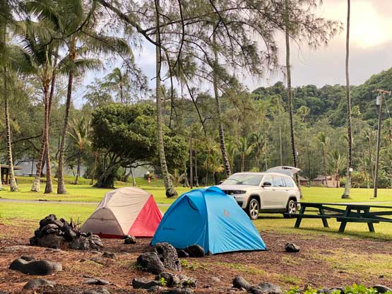
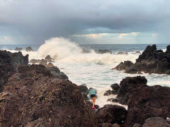
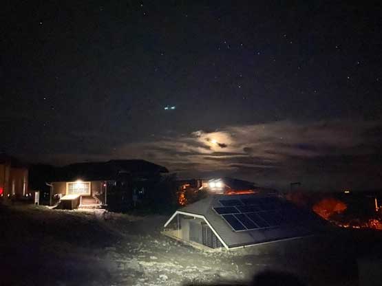
After completing Kaumu o Kaleihoohie in the morning of Day 3 we drove to Laupahoehoe Beach where we’d set up camp for the night. This beach locates on the windward side of the Big Island and subsequently sees more precipitation, moisture and winds. The ideal camping location would be on the lee side of the island but those either involved a rigid gate hour or were fully booked. To take advantage of the morning window we decided to start hiking at 3 am and that further meant we would be leaving the campsite at 1:30 am. The ones with gate hour wouldn’t be open until 5:30 am so that’s why we picked this windward side campsite. The weather was terrible when we arrived but at least we wouldn’t be worrying about the authorities in the morning. The rain stopped at 6 pm so we got out of the vehicle and got the tents erected. Nikita and I then went down to the beach and found some fun scrambling oppourtunities. Unfortunately I don’t think any of the pinnacles we scrambled had enough prominence to be considered as a “summit”. We all turned in early and actually caught a couple hours of sleep. The alarms went off at 12:45 am and we left the beach at 1:20 am as planned. The drive to the trail-head through Hilo went without event but the temperature was colder than anticipated. I decided at the very last minute to actually use my Chimborazo’s system. I started off wearing the Arc’teryx Beta AR pants with long johns while carrying by MEC Storm Degree parka, and I absolutely did not regret this decision.


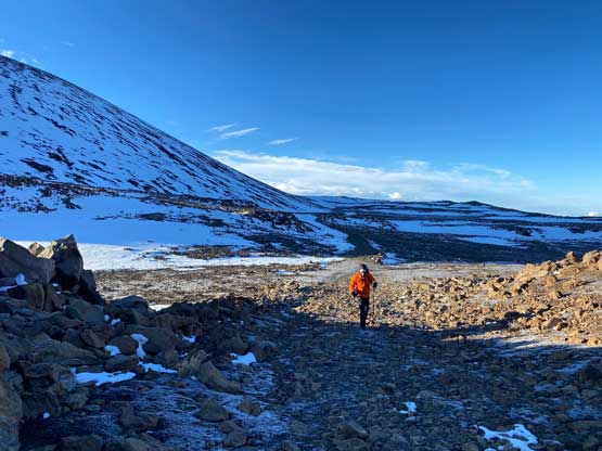
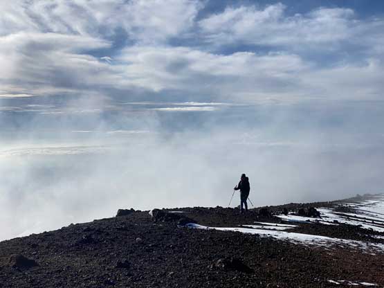
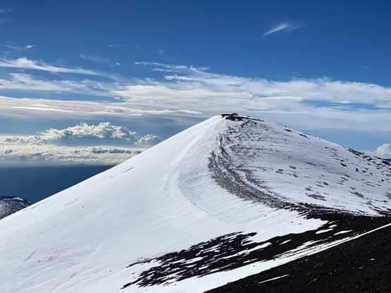
I was told later in the day that even hikers needed to sign in with the authorities and they would arrive at 4 am to grant the permits. I bet in some days they would not let hikers to proceed. Our arrival was much earlier so we proceeded on without knowing. Raphael started off by plodding at a blistering pace but I caught up and swapped the lead. Even though we didn’t started off being at high altitude (only 2750 m) I still preferred a slow but steady ascent into the higher altitude. The lower section of this trail below 3500 m is actually steeper than the upper portions so we dealt with the steeper grades at the beginning. The trail was well-defined and in good conditions. There’s literally not much worth documenting asides the cold and steady head winds. Eventually, a few hours later under the saddle between Pu’uhaukea and Pu’uwaiau we could finally see the gorgeous morning horizon behind. We slowed down and took our time to soak in the views. Pu’uhaukea and Pu’uwaiau are two of the insignificant bumps on Mauna Kea massif that we also wanted to ascend, but in another few hours on the way down.


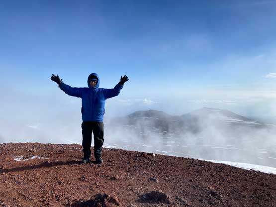
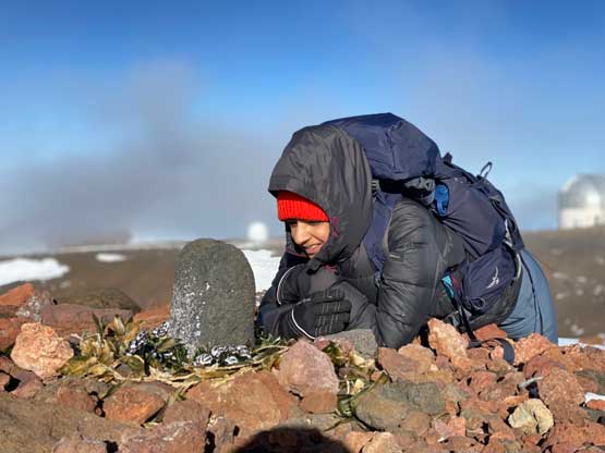
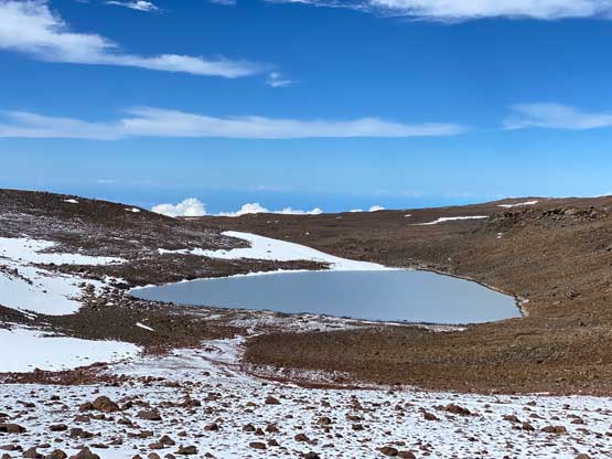
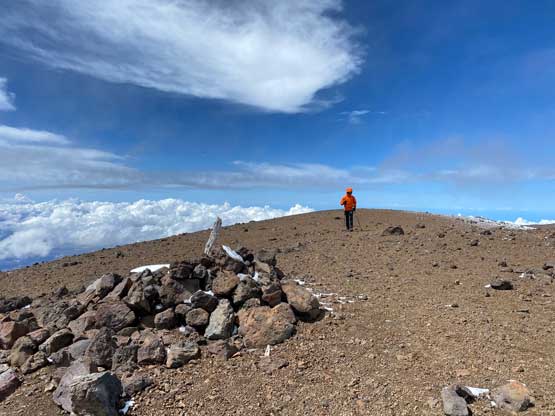
Beyond Pu’uhaukea/Pu’uwaiau saddle there’s a side trail descending to the sacred Lake Waiau whereas the main trail also does a little bit of descending to connect to the upper, paved portion of the access road. We followed the main trail to the road and followed the road eastwards for almost a kilometer. Instead of continuing walking up the road like most hikers did, we opted to leave the road at the easternmost switchback and ascended the open terrain on Mauna Kea’s south ridge which was essentially the “backdoor way”. This would give us the lowest possibility of encountering protesters even though I didn’t there’s any of them up there on this particular day. The true summit of Mauna Kea is considered sacred by Hawaiian culture and technically not permitted to ascend. Nonetheless we ascended the steep south ridge onto the crater rim and traversed to the true summit battling against some gusty winds. I donned all layers except for one stored in the pack for back-up uses. I did not opt to use balaclava nor ski goggles but that’s mostly because we weren’t in the winds for too long. I had to frequently cover up my face using the gloves.


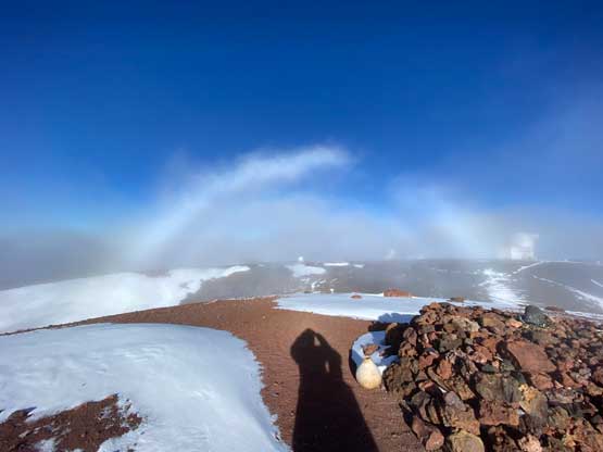


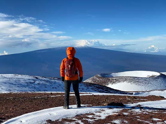
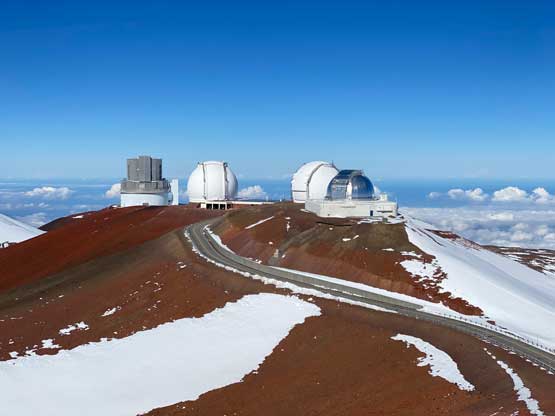
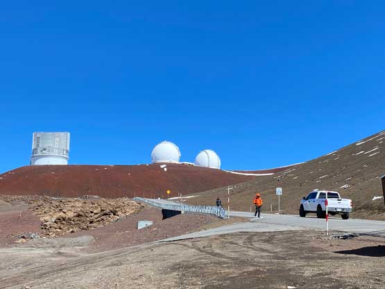
Once everyone showed up and celebrated we immediately descended the north ridge to get out of the winds. We then ascended the south slopes of Pu’ukea to check out the telescopes. Raphael actually inspected a telescope and found a door wasn’t closed, so we all went in to have a more sheltered break. Meanwhile tourists showed up in their Jeeps but it didn’t seem like any of them was planning to ascend the true summit. Raphael and I debated about the exact location of Pu’ukea. The “dot” on peakbagger.com locates at the highest point of the telescopes area whereas the Gaia map puts the label on the northern edge. Raphael and I couldn’t convince each other so the decision was to visit both just to be sure that we definitely bagged this p24m high point… I then led us plunging down the north slopes of Pu’ukea and traversed to the next officially-named bump, Pu’uhau’oki. This was the worst of the peaks we bagged on Mauna Kea and the summit was entirely obscured by the telescope and other kinds of structures.


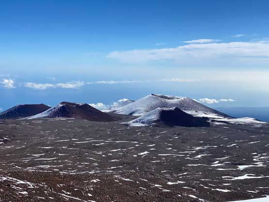


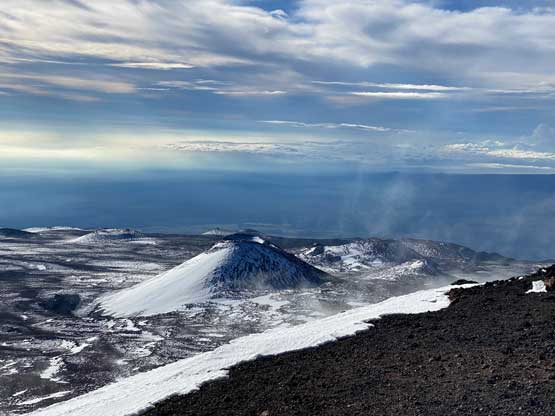
The next objective was Pu’upoli’ahu. Unlike the previous two bumps we had to gain over 80 m elevation to claim the summit of Pu’upoli’ahu after ditching the backpacks at the base. The ascent is however, no brainer as we just needed to plod up a road. There’s enough snow on this peak that some skiers had come in the previous weeks and left their tracks. While descending we talked about skipping Pu’uhaukea and Pu’uwaiau but after regaining some elevation back to Pu’uhaukea/Pu’uwaiau saddle we changed our minds. Nikita opted to skip the more complicated Pu’uhaukea while Raphael and I ditched the packs at the saddle and went for it. The ascent was mostly a scree slog and we disappointedly found a higher summit on the far side of the crater rim. To make sure we definitely could claim the summit of Pu’uhaukea we decided to do a loop traverse around the crater rim, adding considerable amount of elevation and micro-terrain. The three of us then jogged up Pu’uwaiau as it’s simply too easy to skip. We didn’t bother to descend to Lake Waiau because we were tired and hungry and wanted to finish the slog.

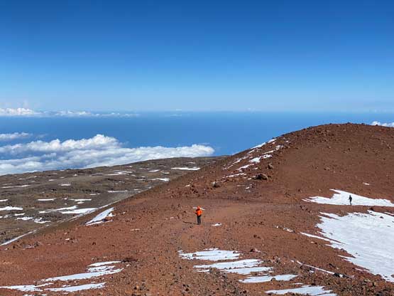


The descent down to Visitor Center was a mind-numbing slog. I was planning to take my time but about one third of the way down Raphael and Nikita started to run. I would not run downhill but didn’t want to be left too far behind, so mostly power-walked the descent. It felt much longer than on the way up but the views were quite nice. The ranger at the trail-head asked us to sign out and that’s where we got confused. We explained that we started at 3 am and didn’t sign anything on the way up. The ranger understood but wouldn’t just let us go and still required us to sign out a form for their official use, so Raphael did that for the group.


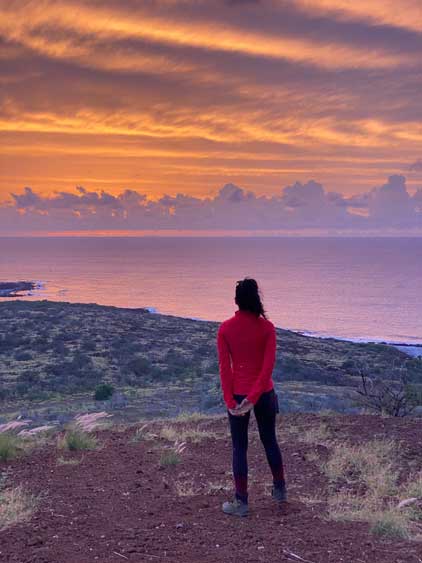
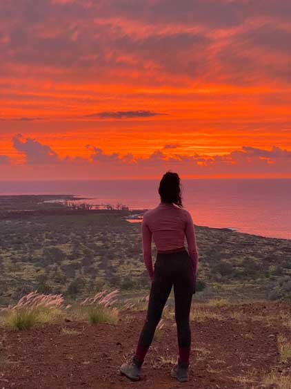
We took our time at the trail-head to change to clean cloths and I made the decision to skip the few bumps at the start of Mauna Kea road. Our priority now was to drive back to Kona for some food. I was tired but managed to stay awake for 1.5 hours. Raphael picked a restaurant literally in the middle of downtown Kona so getting there was a pain in the ass. Finding a spot to park was harder than climbing Mauna Kea and we eventually ended up paying 20 dollars for the 2 hours of parking. The food was good but I wouldn’t say this restaurant was worth the added hassle. I then drove us back to Kona airport to pick up Raphael’s rental car as he would be staying on the Big Island for two more days. By this point we still had an hour of daylight and we made a spontaneous decision to ascend Kuili near Manini’owali Beach. The ascent only took 4 minutes and we were rewarded by a magnificent sunset show. This peaklet is highly recommended for the high view-to-effort ratio. The result of this day was 7 peaks in the bag, all officially named, but only 1 of them boasts over 100 m prominence. The statistics further reinforces the topography of Big Island. There are countless bumps, but the terrain isn’t rugged and most of them have hardly any topographical significance. Nikita and I then returned our Jeep at 8 pm and killed several hours in the airport. We took the Westjet overnight flight straight to Vancouver and I eventually got back home at 10 am. I had several hours to catch up some sleep before the exhausting afternoon/evening work. This concluded our 4-day-4-night smash and grab mission on Hawaii’s Big Island.