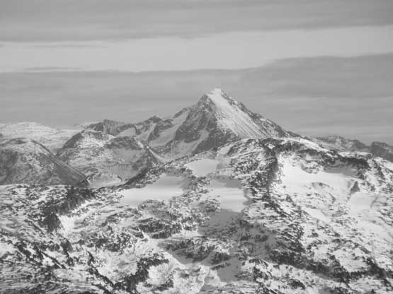
“Hidden Peak” (Callaghan)
November 3, 2019
2273m
Whistler / Callaghan Valley, BC
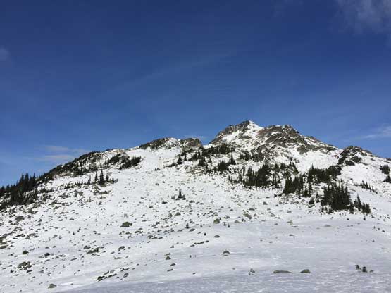
“Hidden Peak” is a minor bump on the long, broad and undulating ridge extending south-east from Mt. Callaghan with barely enough prominence to qualify as a separate summit, but the profile of this peak is rather eye-catching while driving up the Callaghan Lake Road. The name “Hidden Peak” is unofficial but not randomly assigned by bivouac.com. The origin of this name was likely from Callaghan Lodge and the local legend John Baldwin also used the same name in his Exploring Coast Mountains on Skis. The peak itself is a popular destination for skiers based in Callaghan Lodge in the winter, but doesn’t seem to attract hikers in the summer time.
In the past few years I always wanted to ascend this peak in deep winter on snowshoes, even if that meant I had to walk an extra 8.5 km each way on the unplowed Callaghan Lake Road. I had to be honest that I wasn’t particularly keen to walk 17 extra kilometers, if I didn’t have to, so the better plan was to hike it in the so-called “shoulder season”. There would still be enough snow to make the hike a little bit more interesting/satisfying, but not enough snow to obscure the road access such that I could still drive to the trail-head at Callaghan Lake. This past Sunday in the early November offered a prime window and I managed to convince Vlad and Chris to join. This was towards the end of a prolonged period of drought weather that the recent snow had either melted or consolidated to a firm crust. Reports from Saturday indicated that no snowshoe needed even for higher peaks such as Mt. Currie even though two weekends ago, two guys had to turn around on Hidden Peak, due to thigh-deep post-holing even with snowshoes. It took me a while to convince myself that snowshoes were indeed not needed. The other guys were very keen to not bring snowshoes so we left the flotation behind, which turned out to be a mistake.
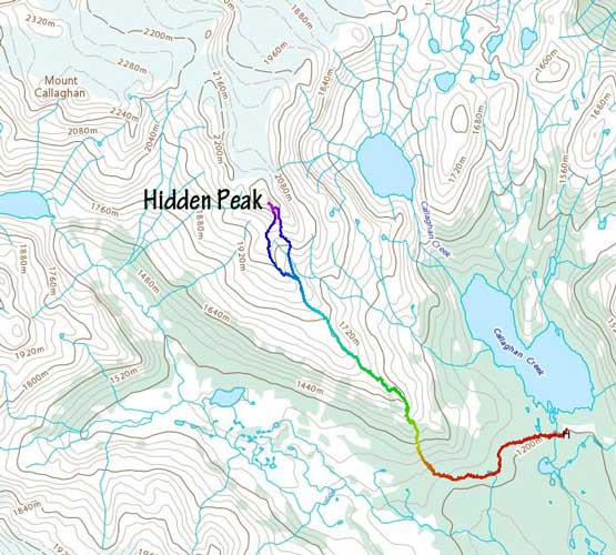
Hidden Peak via SE Ridge. GPX DL
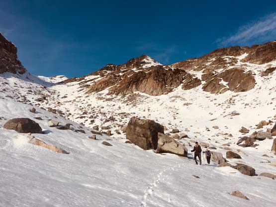
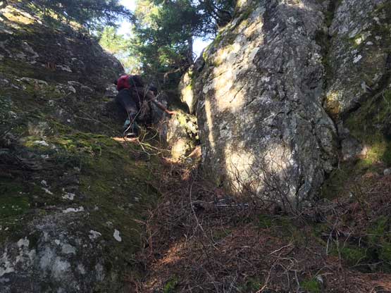
The drive up the familiar Sea-to-Sky Corridor was uneventful but Callaghan Lake Road was rougher than expected with lots of deep waterbars. They did not impose much problem to my Tacoma but vehicles with less clearance might have trouble on some of these ditches. The plan was to follow Simon’s ascent route via the long SE Ridge but to access the lower ridge there were more than just a few options. I spent quite a bit of time studying the maps in the previous evening. The plan was to hike the trail towards Ring Lake for about 1.5 km before starting the bushwhack because this way we might can minimize the total time spent in the forest. The trail was in an excellent shape but very icy in the morning. The bushwhacking wasn’t bad, but wasn’t a casual walk neither that some degree of route-finding was required. We on-purposely scrambled up a 3rd class mossy chimney for fun, and then hit patches of snow. The snow was not nearly as firm as the recent reports indicated making us wonder what’s laying ahead. We post-holed pretty much down to the bottom as the snow offered virtually no support whatsoever, and things only seemed to get worse and worse as we slowly approaching the treeline zone. Knee deep post-holes weren’t uncommon.

Passing a frozen tarn on the main trail
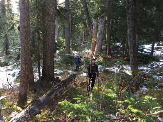
This is the start of the bushwhack

Me scrambling up a 3rd class chimney. Photo by Vlad M.

Vlad and Chris scrambling up the same chimney

Hitting continuous snow now. Lots of post-holing…
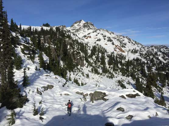
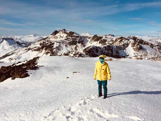
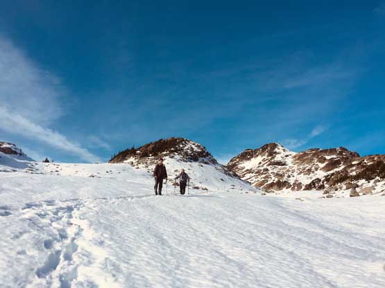
The three of us took a long break once having some nice views. Nobody commented anything about the snow conditions so we kept charging up hoping the condition would improve. The warm temperature on this particular day seemed to have melted down the crust, that we were in for some arduous businesses. Vlad was more motivated at this point and led the next couple hundred meters of elevation gain into the alpine, overcoming a few small sections of micro-terrain. At one point it seemed like we had picked up a set of old snowshoe tracks and by staying on the tracks the post-holing situation had slightly improved. I took over the lead and broke trail up the next few hundred meters of gain, all the way past a few large open plateaus and boulder fields to around 1900 m elevation. I initially decided to traverse into the main drainage on the south-east side of the summit block to follow the main fall-line but the boulder fields seemed rather sketchy with the unsupportive and shallow snow, so made a drastic correction by kicking-step up a steep snow couloir on the climber’s left to access the ridge paralleling the gully, in hoping for either supportive snow or wind-scoured ground.

Vlad post-holing ahead on the typical terrain
The terrain was undulating for a while with some micro-terrain
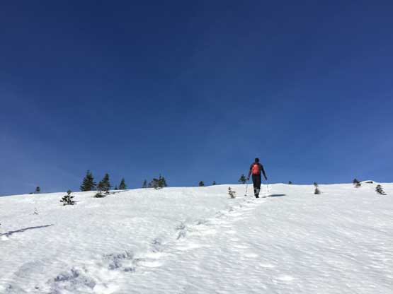
Vlad plodding ahead onto the alpine zone
There’s still a long ways to go for the summit

Vlad plodding across what’s supposed to be a meadow area

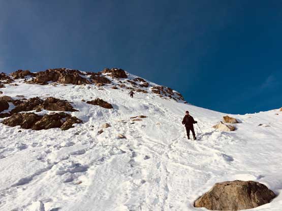
I chose to kick-step up this steep snow slope

Looking back down at Vlad starting the snow climb
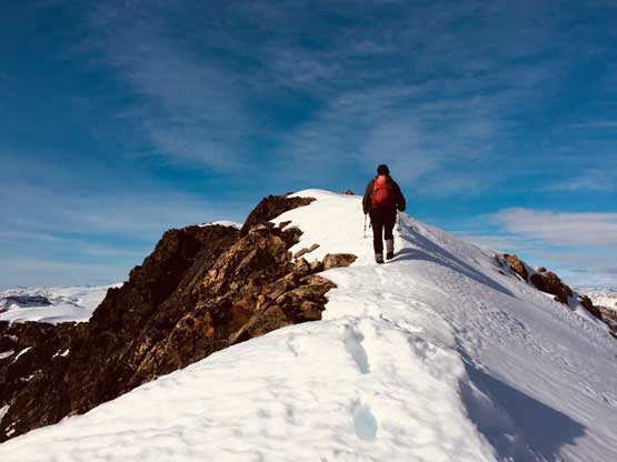
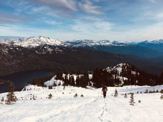
The snow was firm on the NE aspect but we all managed to climb up the couloir without donning crampons. Once onto the ridge we had a section of easy walk and then a short dip before the summit block. We took a long break before ascending the summit block. The plan was to scramble on rock to avoid as much post-holing as possible and the downside was a few 3rd class moves on questionable rocks near the top. Above the rock step we had to traverse an aesthetic snow arete that felt like a mini version of the one of Eldorado Peak.. Despite the lack of prominence this view from this peak was truly outstanding with Cirque Lake stealing the show.

Chris high up on the SE Ridge plodding across another stretch of flats

Ring Mountain and Ring Lake

Vlad starting the scrambling up towards the summit block

Looking back at Chris on another stretch of typical plod

Vlad high up on the summit block scramble now
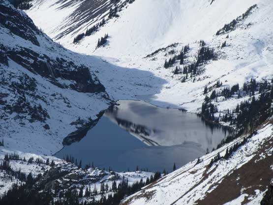
Reflection in Ring Lake

Vlad tackling the loose, 3rd class scrambling step
Vlad on the last few meters to the summit

Me following up the narrow snow arete. Photo by Vlad M.

Partial Summit Panorama from Hidden Peak. Click to view large size.
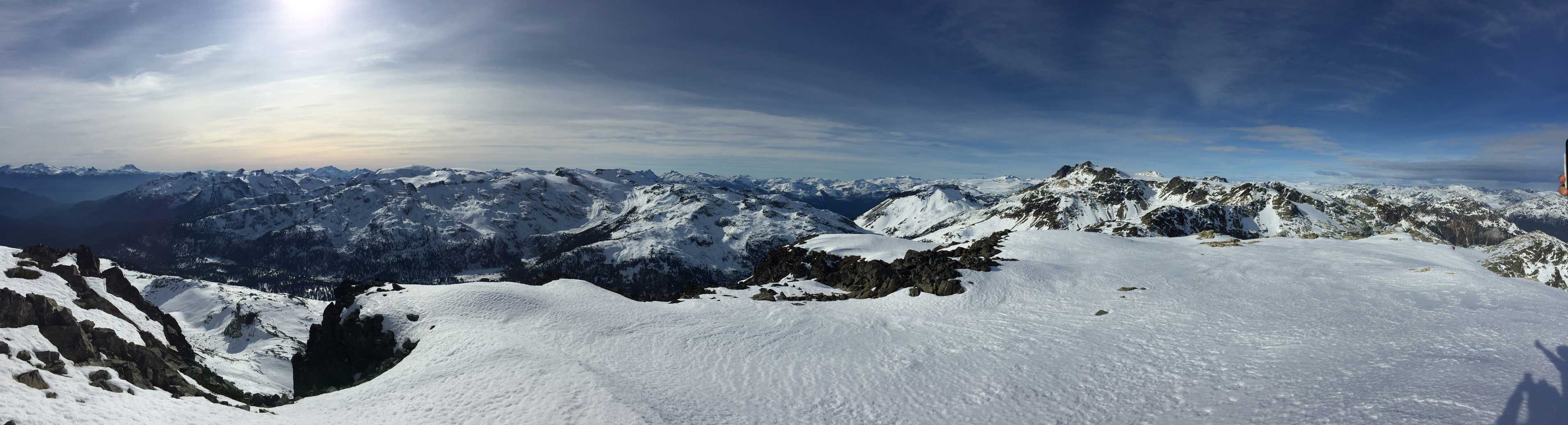
Partial Summit Panorama from Hidden Peak. Click to view large size.
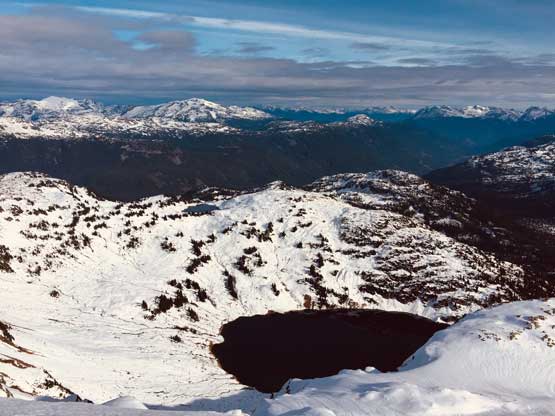
Cirque Lake stealing the show below
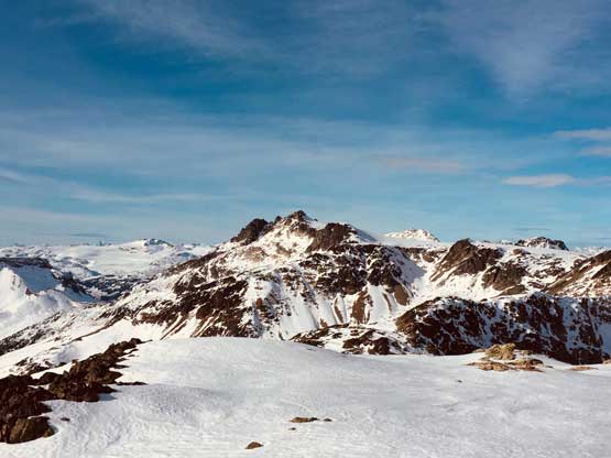
Looking ahead to the ridge linking towards Mt. Callaghan
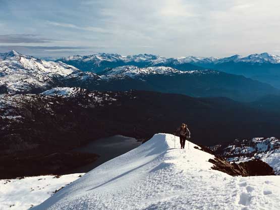
Chris on the final snow arete to the summit
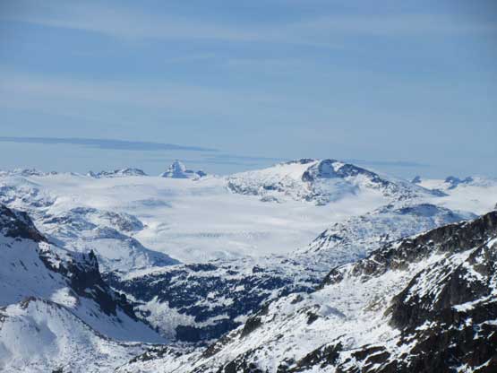
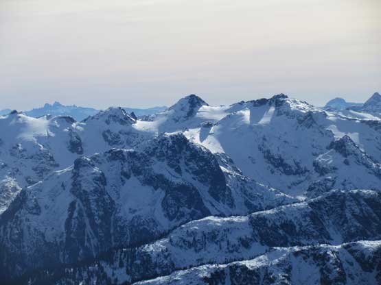
Exodus Peak with the tip of Mt. Tinniswood poking behind
Mt. Albert is a massif from any side

The north face of Ashlu Mountain with Limelight Peak to its right

Powder Mountain with the very tip of Mt. Cayley poking behind
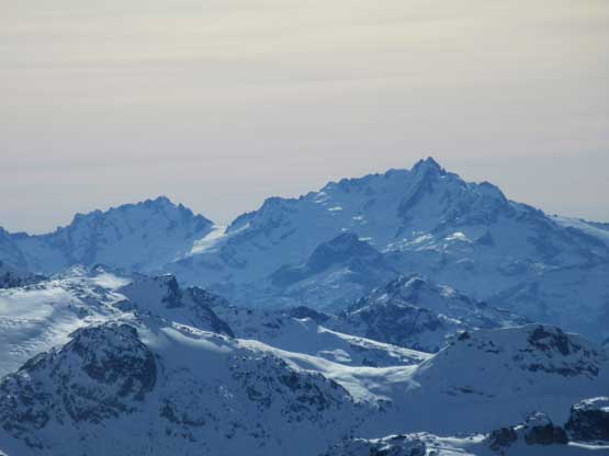
The majestic Mt. Tantalus massif with Serratus Mtn. to its left
The north face of Brandywine Mountain massif
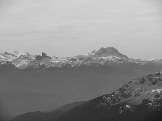
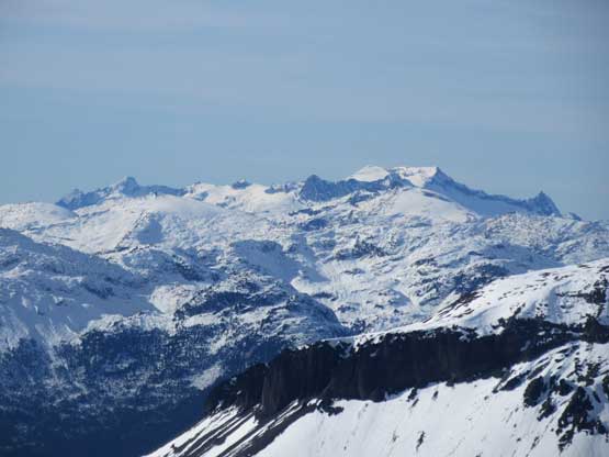
Mt. Garibaldi and The Black Tusk – two icons that need no introduction
Wedge Mountain’s SW aspect pokes behind the rounded Rainbow Mtn.

Looking down Soo River valley towards Mt. Currie and Hibachi Ridge

Me on the summit of Hidden Peak
Another photo of me on the summit of Hidden Peak

Our group shot on the summit of Hidden Peak
We lingered on the summit for more than half an hour before making the commitment to start the descent. We decided to avoid that rock step by plunging/post-holing into a snowy bowl on the south side of the summit block. This led us into a snowy chute that we sped things up by glissading. The bottom of this route had lots of sketchy boulders covered by unsupportive snow that we had to be uber careful. It felt just as sketchy as soloing across a glacier at this time of a year. We all punched through at least a few holes but thankfully nobody got hurt. Plodding down the long and undulating SE Ridge after merging back onto our ascent tracks wasn’t as mentally stressful, but was physically tiring. We had to post-hole on top of our own tracks due to the warm temperature and the few short stretches of elevation regain was particularly annoying. The bushwhacking in the forest lower down was done by GPS navigation and we also down-scrambled that chimney for more fun.
Heading down into the south side bowl

The typical terrain and the typical view. Not much to comment
After finishing the sketchy boulder field minesite
Back onto the SE Ridge

The long and broad SE Ridge descent ahead

Callaghan Lake in foreground with Rainbow Mtn. behind
Vlad plodding towards the treeline zone

This is the typical condition we had to deal with at treeline zone

Into the forest now. No more snow
Down-scrambling the 3rd class chimney
Our round trip time was under 8 hours and that wasn’t bad considering the amount of post-holing we had to deal with. Hidden Peak proved to be an excellent shouder season objective. It’s not that easy with snow, but also not difficult by any mean and that’s pretty much what exactly we were looking for on this particular day. The drive back home was uneventful and the traffic was surprisingly acceptable on a sunny Sunday afternoon.
