Mount Bishop
February 23, 2024
1509m
North Shore Mountains, BC
Mt. Bishop is one of the major summits in the North Shore Mountains that boasts over 600 m prominence, and Raphael suggested it to bag it as a “sunrise hike” on this past Friday. Unfortunately I had already taken two Fridays off in a roll and I could not afford doing that for another time. I was throwing out some other ideas as the weather was supposed to be better elsewhere, but Raphael was very keen on the “P600m” objectives and this was basically the only one left for me that’s doable as a “before work exercise”. Even so, to do Mt. Bishop (round trip over 35 km distance) and still get back to White Rock by 3 pm for work would be pushing the limit. I eventually agreed with the 1:30 am starting time, not to watch sunrise but rather because of my work schedule. The snowpack had some lingering wind slabs problems but had been mostly stable in the North Shore zone (M/L/L ratings) so we would leave the avalanche gears behind to save weight. I did suggest us to bring ice axes, crampons and snowshoes because I couldn’t find sure evidence that those gears weren’t needed. It turned out that we did need snowshoes (even though I thought the chance of needing them was less than 10%), but did not need the ice axe and crampons unless we also planned to traverse towards “Deacon Peak”.
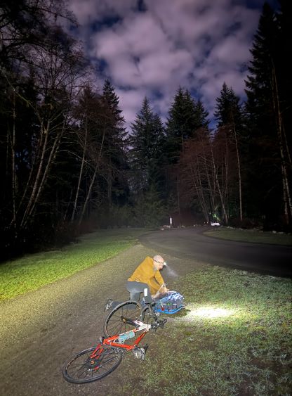
I did not finish work until 10:30 pm on Thursday and I still hadn’t packed anything, so I could have at most 1 hour of sleep and that stayed as in theory. In fact, I did not get a single minute of sleep. By the time I finally finished everything and went to bed it was only 45 minutes before the supposed “wake-up” time, so I simply laid there listening to music while waiting for the alarm to go. I picked up Raphael from his home in North Vancouver at 1:10 am and we did manage to start biking by 1:30 am. There are two starting points for the Seymour Valley approach but the shorter way had some complications with the gate hours. We opted to start at the exact same spot as my Cathedral Mountain’s 2021 trip and that was in the residential areas at the end of Lynn Valley Road. They had put up some 3-hour parking limit signs, but we were still able to find a spot without any restriction, albeit a bit farther away.

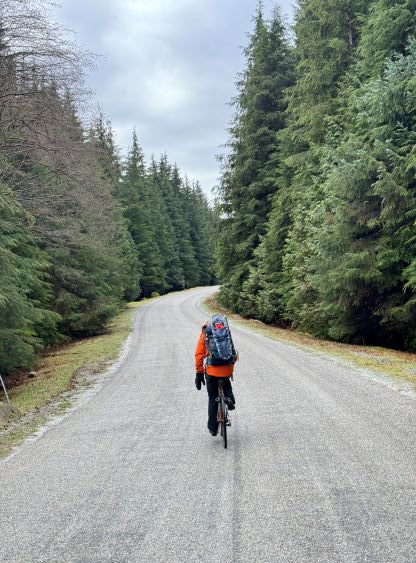
I led us biking down and across the Lynn Creek’s bridge and then up a steep hill to join the paved path. This approach was about 13 km (one way) with lots of up-and-downs but this was as easy as one could expect for a biking approach on any gated access in SW BC. Almost the entire way is paved and all of the uphill sections are mellow enough to be pedaled, even for novice bikers. For this kind of approach one needs a proper road bike if one’s pushing for the speed. I unfortunately only had the fatbike and I struggled to keep up with Raphael on all uphills, flats and downhills. My time from the truck to the trail-head was about 1 hour 15 minutes but Raphael could have easily finished 20 minutes earlier. There’s one steep and sandy section right after the crossing of Seymour River under the watershed’s dam, about 1 km from the trail-head. I could probably have pedaled it up but opted to walk the bike to conserve energy. The actual trail-head was very easy to miss as the last stretch of road leading there was downhill. Raphael had overshot it but I knew it was coming thank to the GPX track downloaded from Tareef’s trip report. It was obvious that Tareef had made that same mistake which I noticed from his GPX track, so I paid more attention and rode down rather slowly.
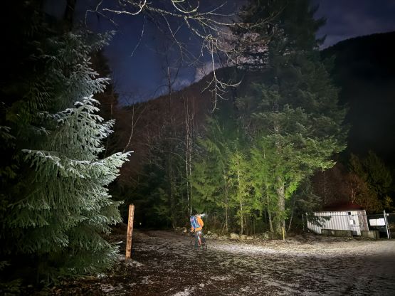

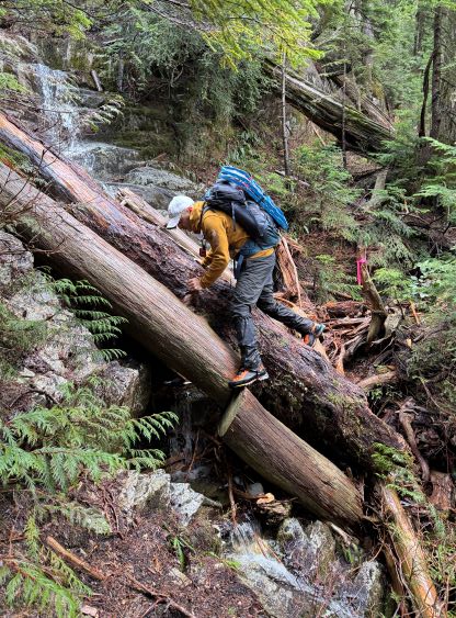
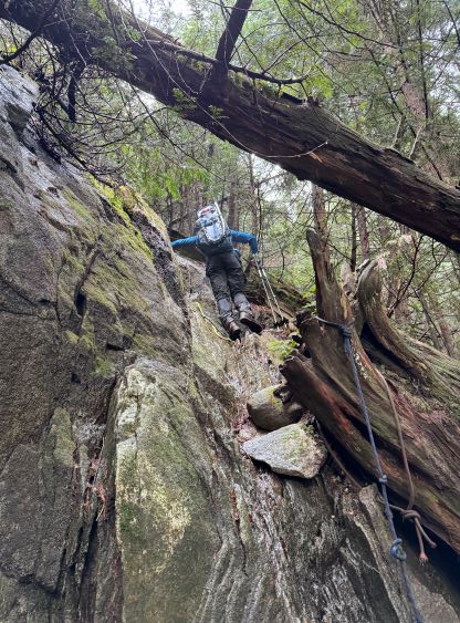
Almost everyone who did this approach had mentioned or complained about the steepness of the trail and I had to agree with them. As far as a “trail” goes this is a terrible one. The route was mostly obvious even in the dark thank to the abundant flagging tapes, but it was relentlessly steep with many scrambling sections up to “class 3” on greasy tree roots. The “Baggers’ Challenge” group had installed more than a dozen fixed lines but Raphael and I were pushing each other to not use the ropes. As a result many of these steps felt like legit 3rd class, and some had decent exposure. I’m not sure if this is the actual “norm” in the North Shore Mountains as I had been on-purposely doing most of the peaks here in winter. This trail actually reminded me the jungle hikes that I did in Indonesia as I could not remember having to consistently pull up 3rd class tree roots elsewhere. Do not get me wrong as it is by any measure still an “on-trail” route, but I’m clicking the “scrambling” icon on the peakbagger app as one does need scrambling skills to do this hike. I’m from the Rockies so I like to see things in an Albertan standard. An averaged Rockies hiker (not scrambler) will have to extensively use the fixed ropes or otherwise, turn around before reaching Vicar Lake.

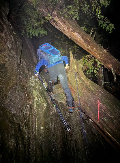
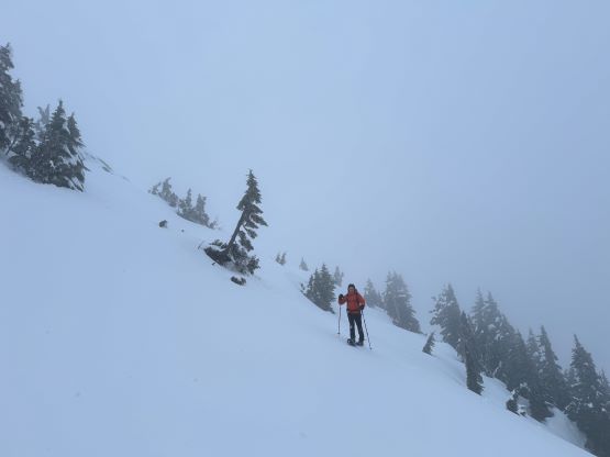
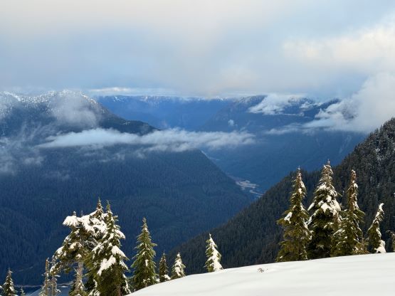
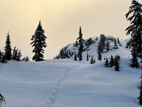
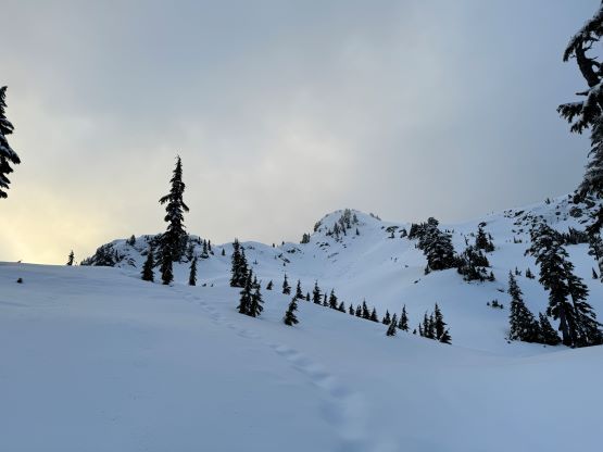
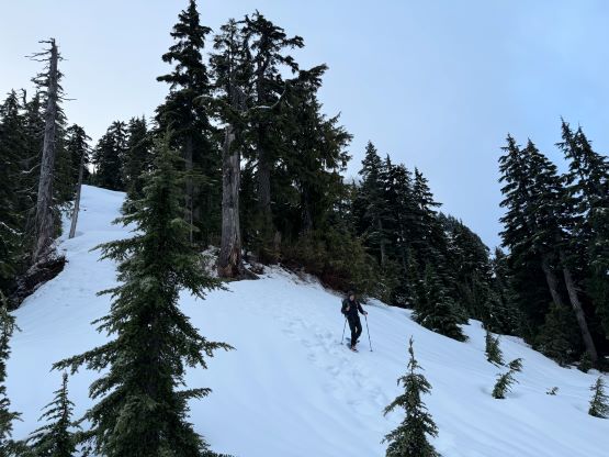
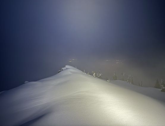
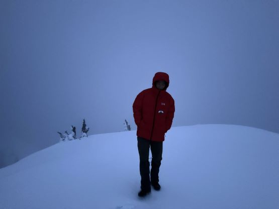
I knew there’s at least one reliable creek at around 800 m elevation so I did not carry more than a liter of water at any given time. I also swapped footwear from trail-runners to mountaineering boots at that creek crossing while loading up the water bottles. Raphael had been exclusively using mountaineering boots since ditching the bikes, and I planned to do the same on the descent as the trail-runners were undertooled for this type of greasy terrain, at least for me. Not far up beyond the creek crossing we started to encounter patchy snow, but the snow did not become continuous until 1150 m after gaining the NW Ridge of Mt. Bishop. The navigation around Vicar Lake and the semi-frozen tarns was a bit tricky but thankfully we had picked up a set of three-to-five-day-old foot prints. The foot prints led us onto the NW Ridge and it was looking like the party had gone for the summit. The most recent precipitation was definitely in the form of snow or wet snow. The top layer had already frozen up but the crust was not strong enough to support our weight, such that I decided to don snowshoes from ~1300 m elevation. We probably could have still made it without the ‘shoes but with them we were able to stay on top of the crust for the rest of the way. Unfortunately the forecasted clear weather did not materialize as a layer of fog came in at around 4:30 am making the summit an entire white-out. After a few steep rolls (steep enough to make snowshoeing treacherous) Raphael and I got there at 5:15 am and stayed for over an hour in hope for some “sunrise” views. We did get some glimpses of views, but nothing satisfactory. I nevertheless had seen most of the North Shore views so I couldn’t care that much. The mission was to bag the peak and get back home in time for work, and we had been successful on the first part. So far, so good.


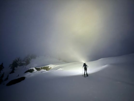

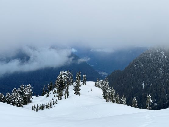
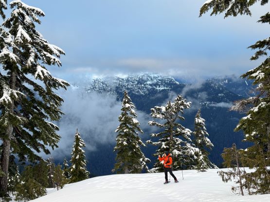
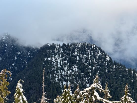
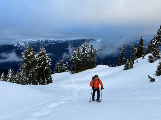
We eventually made the decision to start descending at 7:15 am after seeing no sign for the weather to improve. The top of the cloud layer seemed to be at most another 100-200 m higher, but we unfortunately could not ascend any higher on this particular objective. After losing 150 m elevation we paused as the weather was starting to show signs of improvement and I actually suggested us to plod back up. We did go back for a few minutes and spent another 20 minutes waiting, but eventually gave up. The only views were from below the ceiling and we must accept that. The snowshoeing down the NW Ridge was without event and then we took the ‘shoes off and made a very slow descent back to the ditched bikes. The objective was to not mess things up as we again, tried hard to not use the fixed lines. I simply do not care about those unofficially named bumps with less than 100m prominence, so I don’t think I’ll be slogging back up this way for another time. The 13-km bike ride was again, extremely tiring for me as I was pushing hard to keep up. I was conserving energy on the way in but on the way out I had no excuse to not push as hard as I could. Still, I made Raphael to wait for me consistently from time to time. Our round trip time was 10 hours (including the 1.5 hours of lollygagging on and near the summit). After having lunch I dropped the fatbike at Matt Juhasz’s Bike Shop as that bike needed some maintenance. My original plan was to take an 1-hour nap at home before showing up at work but I had to skip that. The traffic back through Burnaby etc. was brutal and I was so tired that I had to pull over and take a nap. I ended up sleeping for more than an hour and had to rush directly to work afterwards. I was feeling extremely tired again on Highway 91 but I could not afford pulling over for another time, so I pushed it through by rolling down all windows and slapping my face. I got that advice from Eric Gilbertson on the most recent trip (21-hour push with no sleep) we did together. Believe it or not, it actually worked. Needless to say the work time was extremely miserable so after pushing it through I slept for more than 12 hours straight. This had been a classic “type 2 fun” kind of day. I don’t think I enjoyed a single minute from home to home, but I got the job(s) done and for me, that was all.