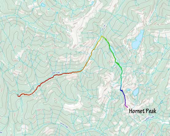
Hornet Peak
January 25, 2022
1928m
Harrison Lake East, BC
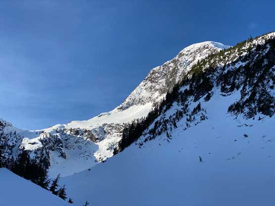
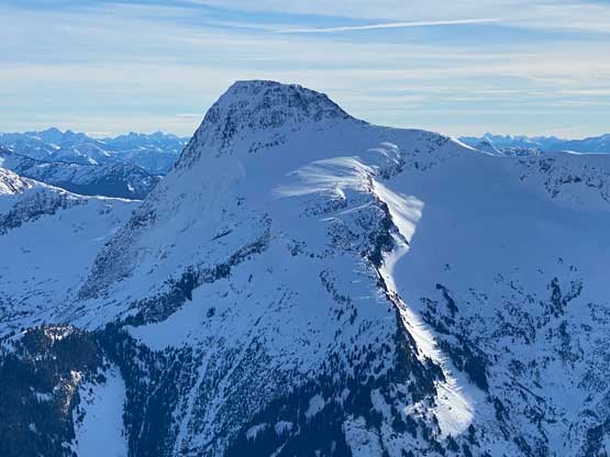
“Hornet Peak” is the unofficial name of the highest peak in an obscured group to the north of Mt. Urquhart and to the south of Mt. Breakenridge in the “East Harrison” area. This group of peaks is so out-of-the-way that finding “beta” online was next to impossible. The most I could find was some folk claiming first recorded ascents of smaller neighbours, “Stoto Peak” and “Clear Peak”. There was no information about the routes on “Hornet Peak” whatsoever. This peak boasts almost 1000 m prominence and subsequently had caught my attention for years, but I always doubted the feasibility. I always thought the logical way was from Hornet Creek to the south, but the satellite images of the overgrown FSR system in Hornet Creek drainage had never boasted confidence.
Matt Juhasz proposed an experimental route from the north side starting from about 3 km past Clear Creek hot springs. I did not take it seriously initially but I did check the route maps because of curiosity. I only checked the upper portions and instantly thought Matt’s idea was bang on as a winter ascent. My concern was the overall length of this route given the low snowline and the wash-outs on Clear Creek FSR. If we had to park at the main Harrison East FSR then we were looking at over 40 km distance, which for Matt was not a deal but definitely pushy for me. Matt was confident that we could definitely drive to around km-5 on Clear Creek FSR and also said some snowmobilers had “jumped the washout” and drove all the way to the hot springs a few weeks ago, such that we could “easily fat bike on their sled tracks”. With firm words that the approach to at least the hot springs would be packed I instantly pushed that we should take advantage of the bomber weather/conditions window to knock this beast off the list.
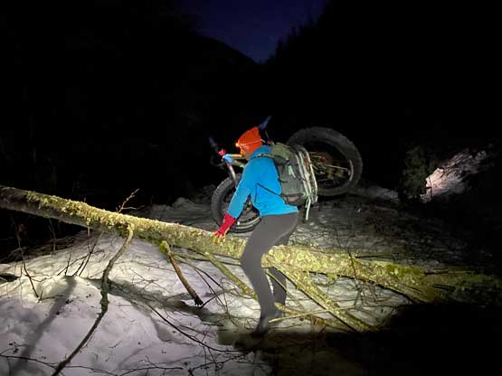
Matteo joined the team at the last minute and even offered to drive his monstrous truck to speed up the access. The three of us grouped in Abbotsford at 4 am and made to Clear Creek somewhere 30-40 km up the Harrison East FSR an hour and half later. Matteo drove literally as crazily as Matt, that we literally flew up the FSR in 100 km/h in the dark. The ride was so bumpy that I wondered if our bikes and snowshoes would still be in the truck’s bed by the time we got there. The Clear Creek FSR had snow right from the start but enough tire tracks. The first few kilometers were fairly straightforward but the snow depth had significantly increased above 300 m elevation. We pushed to between km-4 and 5 to around 500 m elevation and made a sketchy turn-around to park, fearing that pushing any farther would get us in trouble. This was definitely the correct call as another truck got completely stuck about 1 km further, that we found out later at the end of the day.
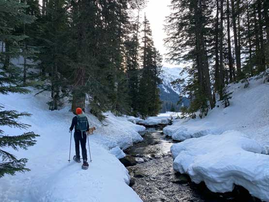
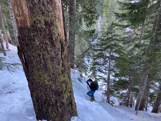
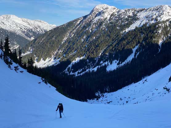
In the pitch dark we started the long ass approach. The hills around where we parked was steep enough that we just pushed the bikes on the existing tire tracks and right away we knew the biking was not as straightforward as anticipated. The crust on the snow was firm, but not firm enough to bike on, and the tire tracks were too deep for us to pedal in. We did manage to pedal a few stretches, but mostly just walked the bike. About 1.5 km from where we parked the tire tracks had fully stopped. The sled tracks were very faint and we started to encounter numerous dead-falls across the road, that in under 2 km from the truck we decided to ditch the bikes for proper foot travel. It was disappointing as this road had some long and flat stretches that biking would definitely be the way to do it, but just not in this particular day. We donned snowshoes right from where we parked the bikes, and thankfully the crust was firm enough to support our weight. Even though we could not bike this road, the conditions were prime for fast-walking on snowshoes. In the first few kilometers we had ascended to just under 550 m elevation but then descended to around 450 m. As mentioned earlier this FSR was flat and undulating with minimal net elevation gain. We did gain about 200 m in the last stretch leading towards the hot springs, about 7 km into the plod. A road junction showed up shortly after the springs. We took the left branch and plodded another 3 km to a bunch of logging clear-cuts where our route would start from.

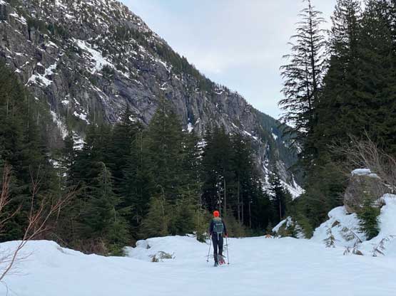
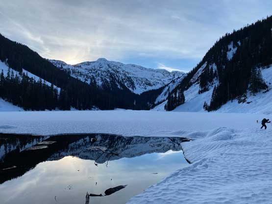
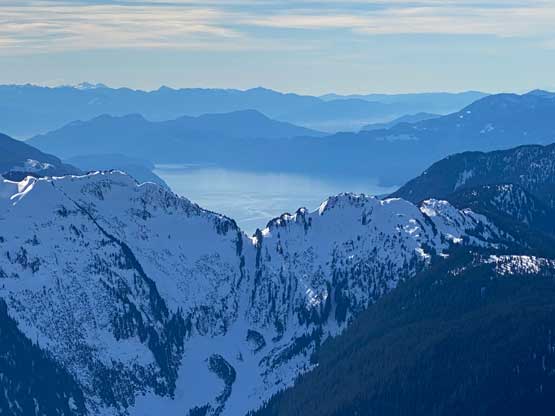
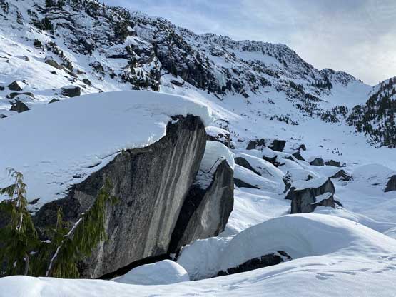
The creek that drained out of our approach valley appeared like a canyon at the bottom, so we ascended the north side cut-block higher than initially planned. I consulted with the maps multiple times and determined that we should ascend even higher to find a “bench” feature in the old growth. This was a good call as the “bench” offered fast travel with minimal side-hilling. We had a minor creek crossing to content with and then descended about 20 m down to the unnamed lake at 900 m elevation. The lake’s outflow was thawed but the main body appeared frozen enough to cross. After the lake we had another 2 km travel in this flat valley between “Clear Peak” and “Big Blue Peak” before picking up another creek to ascend into the “mid draw”. The conditions had been very much ideal as we just floated perfectly on the firm crust with no post-holing whatsoever. The creek leading into the “mid draw” had open waters and started to feel like a canyon again, so we again, ascended a steep section in the forest on climber’s left and made a side-hill traverse where the slope angle eased. We came out of the forest right into the “draw”.


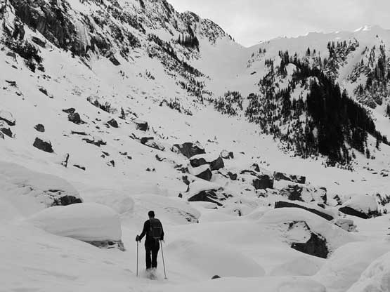
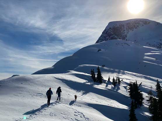
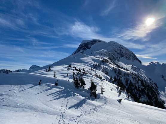
Ahead was the 500-m foreshortened gully that would bring us onto just under the north ridge of Hornet Peak. This gully appeared steep from afar, but turned out to be quite mellow, but boy the slog was a tiring drag. We had not taken a proper food/energy break as the entire day had been in the shades that we desperately wanted to get some sunshine and views. The decision was made to take a break in the sunshine at the top of this gully but I cannot say if we had made the correct decision or not. By the time we made there we were all exhausted and the break we needed was a bit too long for the Midnight Club’s standard. We also started to break trail in about 15-20 cm dry powder on top of the firm crust, about halfway up the gully but the trail-breaking effort was not worth-noting.


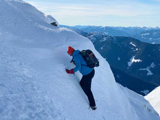
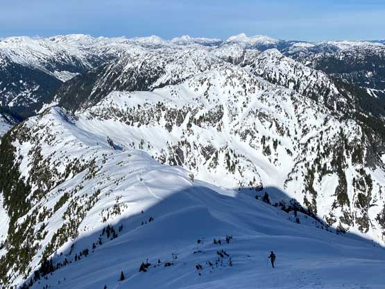
Immediately after this much-needed break we had to ascend a section of steep forest to top out onto the north ridge. I had some concerns about this short stretch based off the topo maps and I was not incorrect. The steepness was a bit insane, averaged 40-45 degrees but the trees were dense enough to offer plenty of vege-belaying. Matteo and I barely ascended this zone with snowshoes on, but Matt had to swap for crampons. Matt then climbed the remaining route with crampons on, but Matteo and I kept our snowshoes all the way to under the steep step much higher on Hornet Peak’s north ridge. For the bulk part the traverse of this north ridge was straightforward with only minor cornices concern.


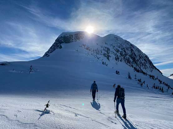
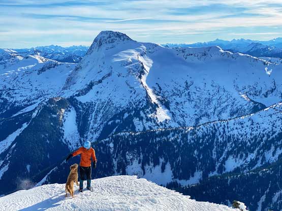
Matt took over the lead at the crux, putting in bucket steps on a section of 45+ degree firm snow. For Matteo and I the climbing was much easier with the existing steps. And then we were looking at the summit block where the topo and satellite maps indicated another steep and uncertain zone. It turned out that we did have to climb another pitch of steep snow, but this one was much easier than what we just did lower down. The summit of this peak was unfortunately an anticlimactic finish of this otherwise awesome route. The summit was dome-shaped that we had to walk around to fully soak in the views, and there’s also an ugly green dildo right where the highest point was.


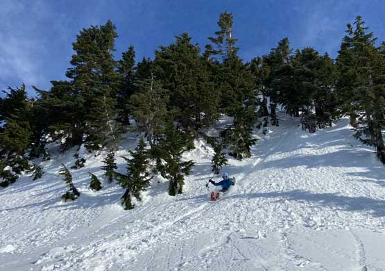
We had a long ways to descend so didn’t stay too long on the summit. Down-climbing that crux step was tricky and required some very careful movements since we only had one ice axe each. We then followed Matt’s lead running down the north ridge with crampons still on. I took a few pictures from behind and right away I fell at least 200 meters behind. I eventually caught up with Matteo at that steep vege-belay section. For the last part of that zone we just made a fast glissade instead of gingerly down-climbing. To run down that 500-m gully we all used different gears. Matt opted for snowshoes, Matteo stayed with micro-spikes while I simply used just boots. There were some post-holing for Matteo and I, but not enough to slow down the momentum. We also glissaded a few steeper stretches. At the bottom of the gully Matt also took off his snowshoes and we stayed in boot travel all the way down to below the frozen lake, where the soft snow in the forest finally forced us to put snowshoes back on. While descending the steep cut-block I took the snowshoes off again, but had to strap them on again for another short stretch of forest just before the Clear Creek FSR.


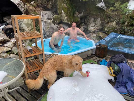
We took the snowshoes off to walk down the FSR and the decision was generally correct. We did have to content with a few stretches of post-holing but for the most parts we had zero or very minimal penetration into the snow as the crust was strong even by the end of the day. We all had brought some extra clothing for the hot springs and paid a visit since it’s right there, so why not. This turned out to be the highlight of this day. It’s also a privilege to have a hot springs to ourselves. The road was washed-out and snowed in, and that kept the tourists at bay. The final kilometer of riding justified bringing bikes on this trip and our round trip was over 32 km distance in just over 10 hours taking in account everything including the hot springs bath.


It’s a long ass day for Matteo since he still had another 2 hours of hard focus to safely get us out of the backroads. The ride was just as bumpy as in the morning, but not quite as fast. We then stopped for a proper dinner in Harrison before resuming the drive back home. I eventually got back home at 8 pm.
