Mount Sarbach
August 31, 2012
3155m
Icefield Parkway (South), AB
My original plan for this Friday was a short objective, namely Nigel Peak, to give a good warm-up for the upcoming long weekend, however, when Marko invited me to Mt. Sarbach, I couldn’t resist to go for this one. This is the big peak overlooking Saskatchewan Crossing on the south-west side and is as “major scramble” in Alan Kane’s Scrambles in the Canadian Rockies. It’s rated as “difficult” and requires more than 1700 m elevation gain. I didn’t leave Edmonton until almost 8 pm, and arrived at Saskatchewan Crossing near midnight. After a not-so-pleasant car camping I met Marko, Alan and Greg Ng in the next morning. We started at almost 7 am.
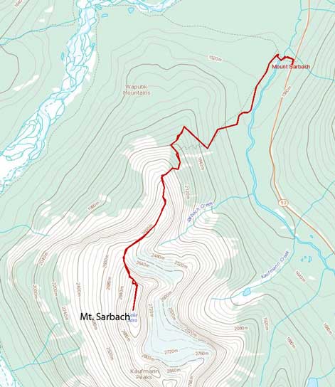
Mt. Sarbach standard scramble route
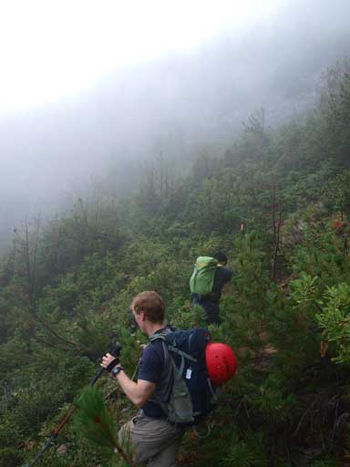
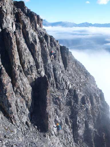
I didn’t have time to do a full warm-up, so I was very glad that Marko led a slower pace up the initial trail. The Sarbach Lookout trail was easy to follow. There were several deadfalls to negotiate on the way in. Trail got narrower and a little bushier higher up, and we got soaked pretty quick. We took turn to lead as non of us wanted to get wet feet at the start of the day. We entered the fog/clouds pretty quickly, and now we couldn’t see anything except for trees and ourselves. Not far up, we made to Sarbach Lookout. There was a lookout station, but we couldn’t see anything else. We followed a narrow trail on the other side of the station. This trail went horizontally and slightly down-hill… Oh well, after following it for several hundred meters, it disappeared into bushes. We got confused by after checking Marko’s GPS we decided to ascend straight up. It worked and we regained trails/paths pretty quickly. There were also tens of cairns to guide us in the white-out condition. It feels like forever to gain the north ridge, and this section really reminded me about the white-out ascent on Fisher Peak. Similar terrain, similar grade, similar views…
Where we were going??!!
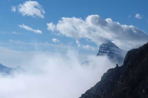
All the sudden, sunshine!! Then, blue sky!! Oh Geez, I couldn’t believe we broke through the low clouds! We could briefly see Mt. Wilson poking out about the clouds, but soon, they rolled in again.. This gave us enough motivation and we speeded up a bit and minutes later, we were officially standing above the clouds. I couldn’t believe my eyes.. This was my first time seeing low clouds scenery and it was absolutely amazing. Now, photographing time! Each of us took endless photos while trudging up the north ridge. We did notice there’s some fresh snow fallen during the night before, and Mt. Sarbach is rated as difficult and exposed, but non of us brought up ice axe nor crampons. However, we all had lots of winter scramble experience so we should be okay.
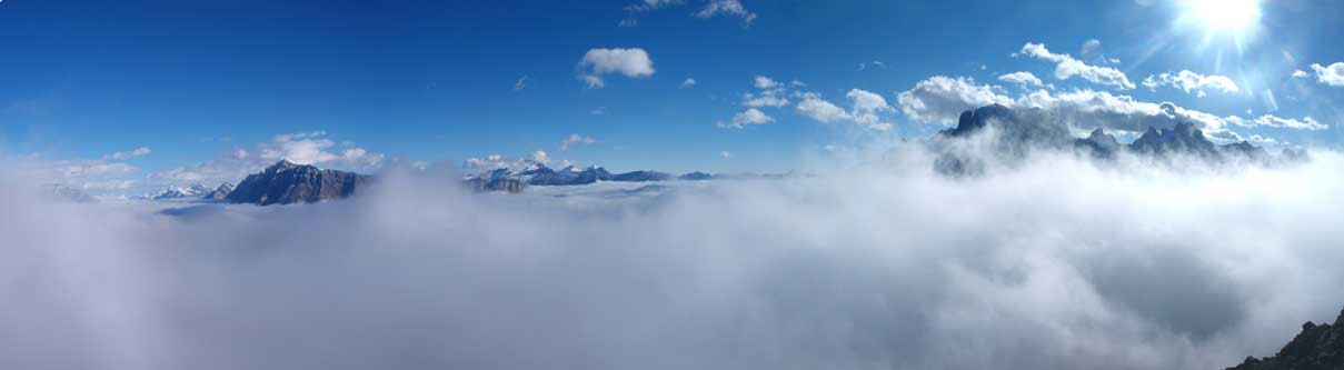
Just topped above low clouds

Mount Outdram on left. Lyell Icefield on right.

Erasmus left of center.

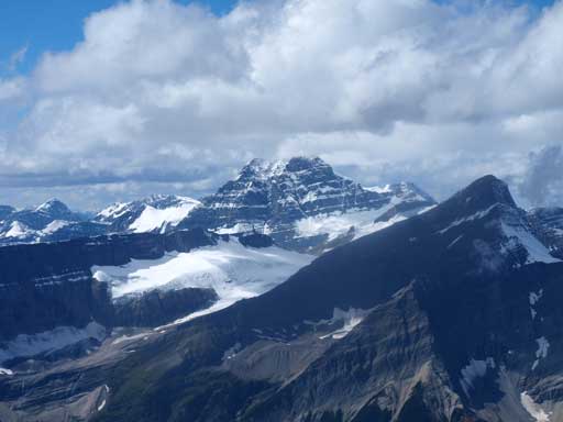
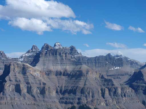
The big peak is Mount Wilson
Mount Cline and Resolute Mountain on left. Looking into N. Saskatchewan River Valley.

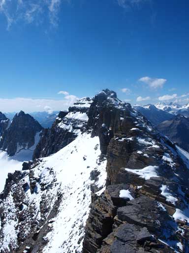
Looking up the N. Ridge of Mount Sarbach

Sometimes the clouds rolled in
Mt. Chephren looming behind

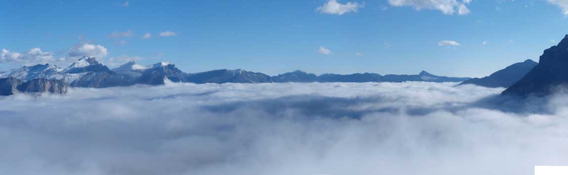
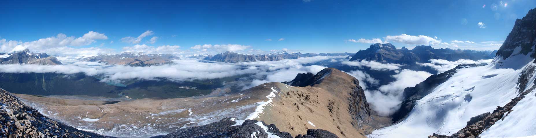
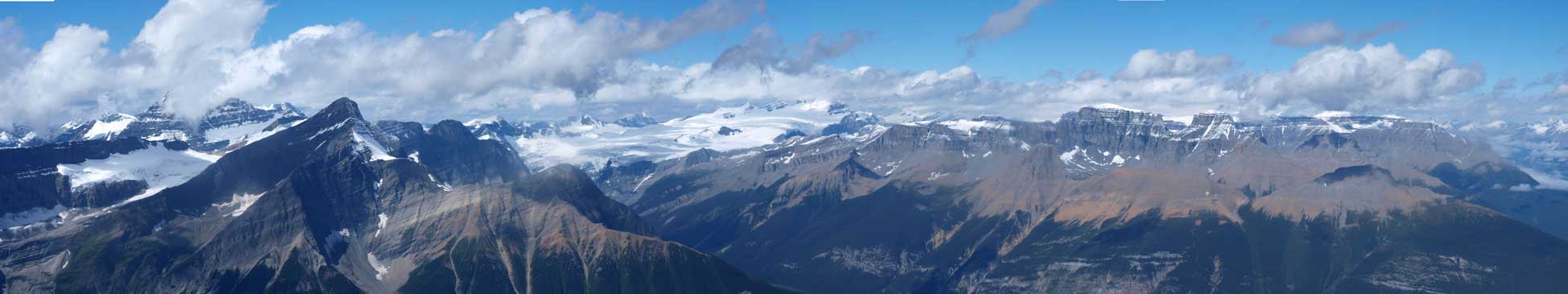
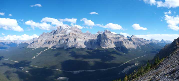
A panorama looking southwards towards peaks guarding Mistaya River Valley
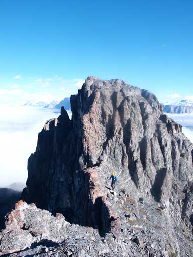
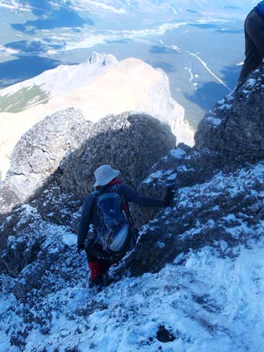
In short time we arrived at the first notch. It didn’t look bad at all, and I quickly made my way through. Coming back up the notch was a bit involved due to the very loose rock. Technically it’s moderate scramble but due to the loose rock, you gotta use caution. Looking back, I got some good shots of the cliff.

Marko looking down a cliff near 1st notch
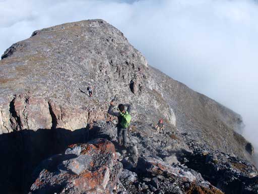
Looking back from across the first notch.
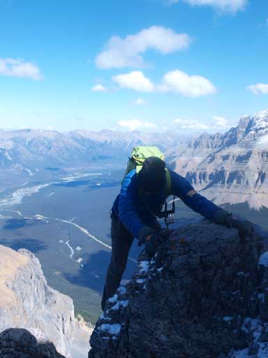
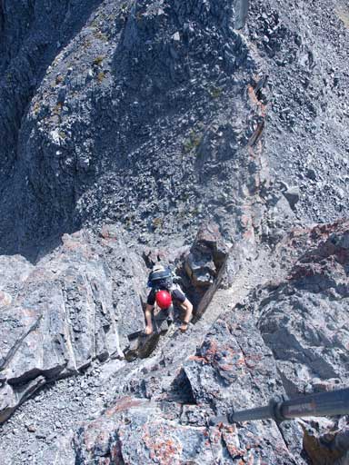
The 2nd notch was only 2 min away from the 1st one. This one looked quite steep from above, but appeared like a chimney climb. This time Alan and Greg led the way down towards skier’s left to aim for some less steep terrain. I looked down the most direct line – the chimney, and it looked very doable to me. Therefore Marko and I decided to down-climb this chimney. Good call. The holds were good and rock was solid. I could face outward the entire way down and it was pretty easy. By the time Marko and I made our way down, Greg and Alan still had halfway to go. I give it a rating of “lower difficult”. It’s easier than some “difficult” scrambles that I did in the past few months, including the down-climb from Pollinger to McArthur, andthe Kane chimney on Mt. Edith.
The second notch ahead
Marko down-climbing the chimney
Grag and Alan decided to skirt around, which proved to be more difficult.
Looking back at the down-climb. It doesn’t look like a notch from this angle.
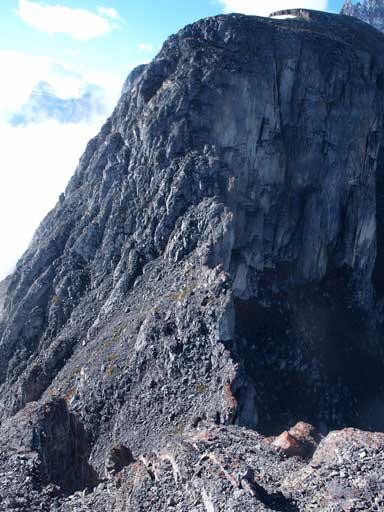
We regrouped after this crux and the following hour was slogging up easy terrain. Going up the next step brought us up to the football field sized plateau. By now, the view towards Mistaya Valley and Mt. Chephren / White Pyramid fully opened up. Higher up, Marko, Alan, and Greg decided to have a snack break. It was a bit windy and I felt good on energy so I figured there’s no need to take that break, so resumed the ascent by myself.
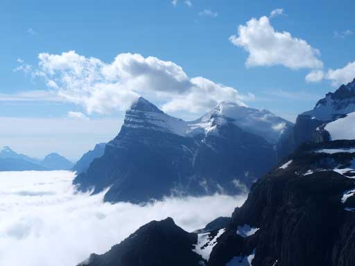
Mount Chephren and White Pyramid

The fractured glacier on the East side of Sarbach

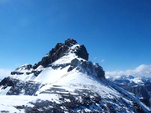
Mount Sarbach. Route goes up the right skyline.
Panorama from the base of N. Ridge. The clouds are lifting up.

Glacier Lake
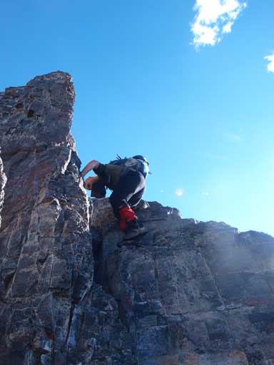
The north ridge started pretty easily, but the higher I got to the steeper the terrain became. Near the top, I encountered snow covered difficult terrain. I went straight up the ridge overcoming what I thought was “upper difficult” rock bands. There was loose rock and snow as well, so I had to use extra caution not to slip. At places a slip could easily be fatal. (Later on the way down, I learned all of those difficulties could be skirted around on climber’s right side)… Oh well, I was happy to do some extra difficult scrambling anyway. Topping out on the upper ridge crest, it was only minutes away from the false summit. I ascended the false summit which proved to be very unnecessary.

Looking down at the tricky section I just came up. There exists an easier line on climber’s right.
Looking towards the true summit from false summit.
I managed to get down steep terrain on the north side of the false summit instead of backtracking. Further up the ridge, I also ascended the first pinnacle, which was proved to be another bad call. The ridge came to a drop-off with no easy way down, and I had to backtrack. I managed to post-hole while circumventing the base of the pinnacles, and found a less steep place to regain the ridge crest. Now it was mostly a nice ridge walk until the summit block. Due to the snow, I had to double check the holds, but nothing tricky. Soon I made to the infamous last 15 meters. Man, that was much easier than what’s described in Kane’s book. If you can do Lady MacDonald and Compression Ridge, then you can do this, although I wasn’t impressed with the rock quality with some major chunks easily wobbling.

Looking back to False summit.
The true summit
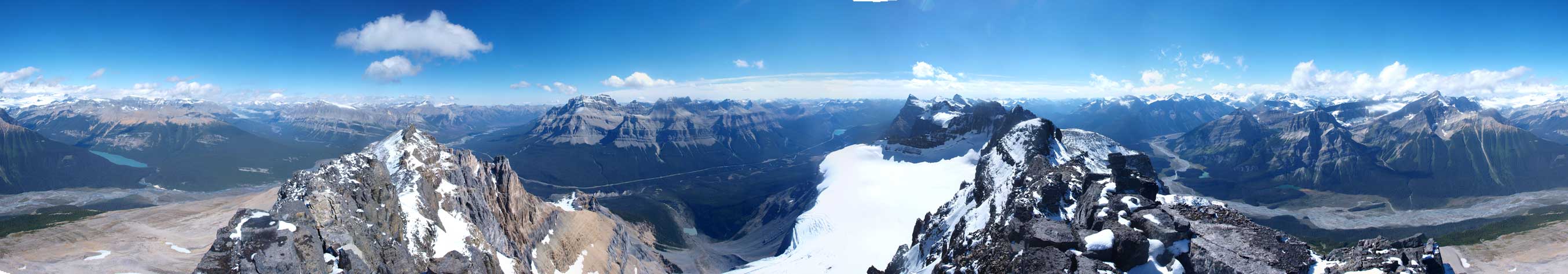
Summit Panorama. Click to view large size.

Chephren, White Pyramid, Hawse Peak, with Epaulette and Kaufman Peaks in front.

Panorama of Freshfield Icefield
Panorama of Forbes to Lyell Icefield

Panorama of Mount Murchison and Murchison Towers

Alan starting the summit ridge

More of summit ridge

Alan finishing the last step

Me on the summit
Mount Forbes
It was pretty cold on the top, so we didn’t do a super long summit stay. Going down snow covered terrain was definitely quicker than going up. We bypassed the false summit on the left side, and looking back, Mt. Forbes finally decided to show up her shy face. That’s another prize for the already amazing day. While Alan went down the easy to moderate terrain on skier’s left of the ridge crest, Greg, Marko, and I went down the way I came up. It was not that bad coming down as we could butt-shuffle which required less pushing power than going uphill. On questionable rock, this could make a big difference on your confidence level. I felt coming down was considerably easier.
Route around False summit goes left of the rock on this photo
Marko descending a loose section.
Greg down-climbing an optional step
Alan patiently waited for us down-climbing, and we regrouped further down. Therefore, if you choose to skirt around the difficulties, then this entire section is only moderate. I was pretty amazed by Marko who didn’t use poles on the entire descent. I couldn’t descend without poles comfortably on any terrain except for scree run, snow, and hiking trail… Oh well. Under the afternoon sun, North Saskatchewan River Valley and the giants guarding the Crossing, namely Wilson and Murchison, looked amazingly good. They guard the Crossing just like Cascade and Rundle guarding Banff. Both of which are on my “to-do list”..

Panorama of N. Saskatchewan River Valley.

The E. Face of Mount Sarbach

Sarbach Glacier
Murchison Towers

Mount Murchison
We all climbed back up the crack on the 2nd notch. Alan and Greg agreed that this way was much easier than the loose rock on climber’s right. After that the loose terrain around the 1st notch was soon negotiated. Once near the treeline, we got confused about where we came up. We were completely in the clouds in the morning so I couldn’t remember anything about our ascending route. We spotted a less forested area and went down that direction. Good call as we cot scree skiing for a fairly long section. Lower down, we managed to stay in the middle of the gully, while descending grass slope. The gully ends by cliffs that could be down-climbed. We skirted around the cliffs on skier’s right and after slight bushwhacking we could spot the trail. On the way back, we didn’t see the lookout station, so I think we came down meeting the trail lower than the lookout. Anyway, I guess there’re more than one options and they all work. The trail went on really forever. The section at valley floor was also surprisingly long. After what seemed like an eternity we made back to the tourist’s Maligne Canyon. Another 5 min then we were back to parking lot.

Marko climbing up the chimney on the 2nd notch

Higher up, Marko mastering the chimney

Alan starting the chimney
Same as above
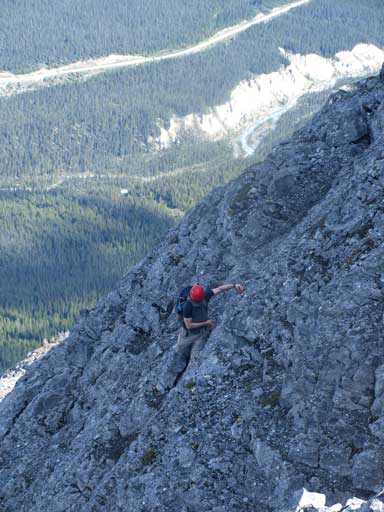
Alan negotiating the loose terrain in the 1st notch

Greg’s turn for the 1st notch

Afternoon view of Mount Wilson
Mount Murchison
Overall, it was a great day in the mountain with great companies. I’d like to go out with these guys again for sure. And speaking this objective, Mt. Sarbach remains one of my favourate Kane’s scrambles of all time. I can’t say it’s the “best” but certainly one of the most memorable. I’d highly recommend this one to folks comfortable on long day and loose terrain.
