Volcán Llullaillaco
January 31-February 3, 2020
6739m
Antofagasta / Puna de Atacama, Chile/Argentina
Volcán Llullaillaco is a massif, stand-alone but extremely remote stratovolcano on the crest of the Andes a couple hundred kilometers south-west of Antofagasta in northern Chile. This peak is the 7th highest in South America and locates in its namesake national park. The peak can be accessed from both sides of the divide. From the Argentina side it takes several days just to drive to the “trail-head” from the nearest city. From Chile side the access is shorter but still requires half a day’s of driving on rough roads. Some mining roads on the Chilean side were land-mined and climbers are required to not deviate much from the standard route. In addition to that, finding up-to-date information about this climb could be just as challenging as the climb itself, especially if one doesn’t read Spanish well. The reason is simple, as most foreign climbers are drawn to Aconcagua and Ojos del Salado to the south.
The decision to ascend Volcán Llullaillaco was a last-minute one between Connor and I. Earlier in this trip we had already climbed Mercedario, Marmolejo and Ojos del Salado. We were then drawn northwards by the weather as we wanted to chase the sun. We were aware that the conditions on these mountains might not be ideal based on what we just experienced on Ojos del Salado but we made a bold assumption that the snow wouldn’t be worse, given the lowered altitude. I should say that the assumption was more of a “hope” as we had absolutely no idea what to expect. Not to mention that Volcán Llullaillaco is only 150 m lower than Ojos del Salado.

Volcán Llullaillaco from Chile side. GPX DL
Connor reads and speaks Spanish and did all of the research and paper work to get us to Antofagasta. We booked the early morning bus ride from Copiapó. The ride was at 5:30 am which meant we had to get up at 4:30 am. It was too early for my like but I reluctantly agreed as the earlier we went, the more likely we could make to the CONAF Refugio on Day 1. The worst was dragging my luggage case and duffle bag (each weighs more than 20 kg) for four blocks to the bus station, as we refused to call for a taxi. I was already exhausted but at least I could catch up some sleep on the bus. The seating was much more comfortable than on an airplane and I slept for at least 4 hours out of the 6 from Copiapó to Antofagasta. The city of Antofagasta feels very industrial but is much prettier than Copiapó as it locates on the beach. We had no time to explore the city though. We immediately took a taxi to the Econorent to get our rental truck. It wasn’t a Toyota but has all-terrain tires and was only two third of the price of a Toyota Hilux. Our next stop was a grocery store for last-minute food and water jugs and the final stop was a gas station. We still had enough gasoline for the stove but we needed to load enough diesel for the truck.
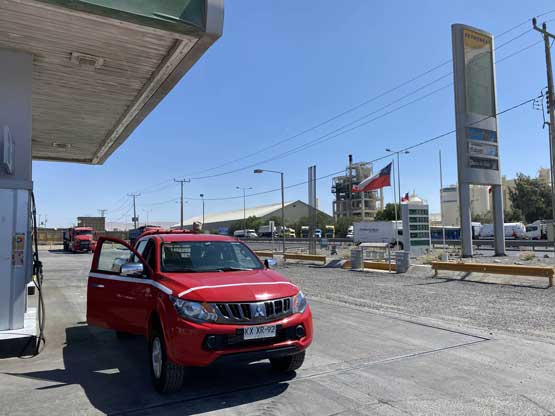
Our last stop before hitting the road
In the previous evening we had spent a few hours just to figure out the direction to get into the national park as the roads were not marked on Google Map at all. There were roads on my Gaia map but figuring out which-is-which was extremely time consuming and frustrating. Connor did get the job done so off we went. Our first aim was Minera Escondida a huge-ass mine about two hours west of Antofagasta. Along the way we really appreciated the importance of mining and engineering in this country. Two of the ten trucks we passed would carry tanks of sulphuric acid which kind of reminded me some parts of China more than decade ago.. We literally drove into and then out of their work zone and once past the mine we continued down the main road towards Paso Socompa for about half an hour before bailing onto the dirt roads. Our objective loomed massively ahead even though it’s still more than 100 km away. There were signs for Llullaillaco National Park which surprised us a little bit, and the roads on my Gaia map proved themselves to be accurate. For the next hour or so we followed the Gaia map down a major dirt road. There’s a sign that indicated where exactly to leave the road for the national park. There was no “spur road” and instead, we basically just drove onto the desert floor but there were enough tire tracks to guide us. After a long while the tracks converged and the “road” reappeared. Generally speaking the quality of this road was better than expected. There were at least a couple steep and very rough spots that required high clearance but in terms of major obstacles there was none. We got to the CONAF Refugio at dusk and were surprised by the quality of this hut. There was nobody around (not to our surprise), but literally, the hut was in a better shape than the averaged hotel rooms. Except for not having hot shower and wifi we could literally spend a week there hanging around… There was solar powered electricity that we used for illumination and to charge our electronics as well as propane stoves for cooking and everything seemed to function pretty well.
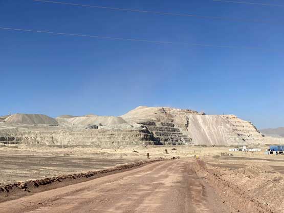
Entering Minera Escondida the largest mine I’ve seen in person

Volcán Llullaillaco rises over 3000 m behind the barren Atacama Desert

Volcán Llullaillaco gets a lot closer now

Finally started to see some vegetation on the ground. Vicuñas too..

Another photo of our objective – Volcán Llullaillaco
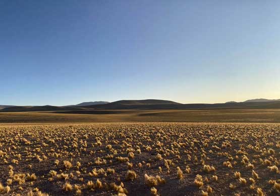
The vast landscape that one can only see here in Puna de Atacama

Our truck entering the park. For the most parts the road was good

Almost arriving at the refugio, in time for sunset
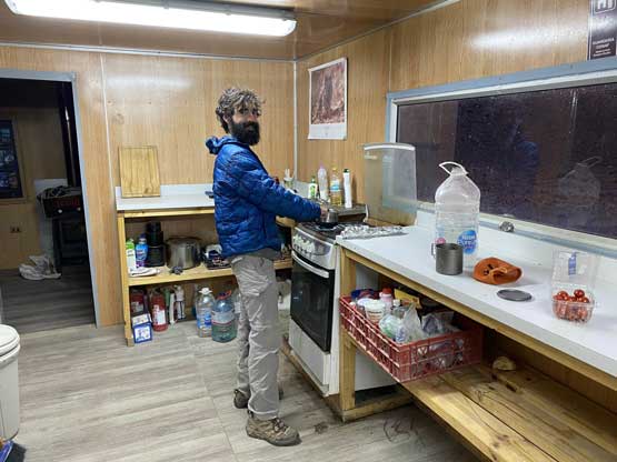
We had the whole park to ourselves. The refugio was luxurious

CONAF Refugio. (4150 m)
There was also a large topographic map labelling important route information that we could not find elsewhere on the internet. For the most important, it marked really well the start of the spur road that leads up to the “trail-head” at around 4600 m. It also showed which of the roads around were land-mined. The objective for the next day was to complete the approach to the high camp at around 5700 m so there’s no rush needed. We took our time in the morning taking full advantage of the luxurious refugio. The drive to the “trail-head” was slow-going but not difficult. We did however, have to park at about 100 m lower than suggested. There were tent sites nearby indicating others also had parked at the same place. Our plan was to complete the climb in no more than 3 days so our packs weren’t super heavy. I also opted to wear the Phantom 6000 boots right from the beginning just to reduce the weight of my pack. From where we parked to around 5200 m was an easy plod up a dry gulch but the plod seemed never-ending. Above 5200 m we started encountering patchy snow and the snow soon became deeper and more continuous. We learnt right away that the snow condition wasn’t the same as we thought because we post-holed down to the ground. To be honest it was past noon already so we hoped the snow could solidify in the morning. I did notice, however, that the snow here “felt” more Rockies than coastal and I worried it might not be dense/wet enough to form the supportive crust that we needed. I did not speak my concern out as I just hoped that I was wrong… We did not go all the way to the planned elevation and instead, we found a good spot at 5550 m altitude and set up camp there. We had to spend more than half an hour digging snow out of the tent site (without a shovel) and to obtain drinking water we also had to melt snow, which was annoying and tedious. We went to bed at sunset and the alarm was set at 5 am.

The morning of our approach day.

Vicuñas on roads

We parked just under 4600 m elevation
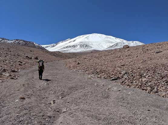
Me heading up the dry gulch. Photo by Connor M.

Connor plodding the typical terrain on the lower 500 m

Our objective slowly gets closer

Looking back from above a steep roll

We entered the snow zone abruptly
Me plodding up on just one microscopic section. Photo by Connor M.

We opted to pitch our tents here

Resting in the afternoon

Melting snow in the evening was tedious
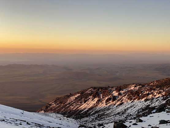
A zoomed-in shot of the evening horizon

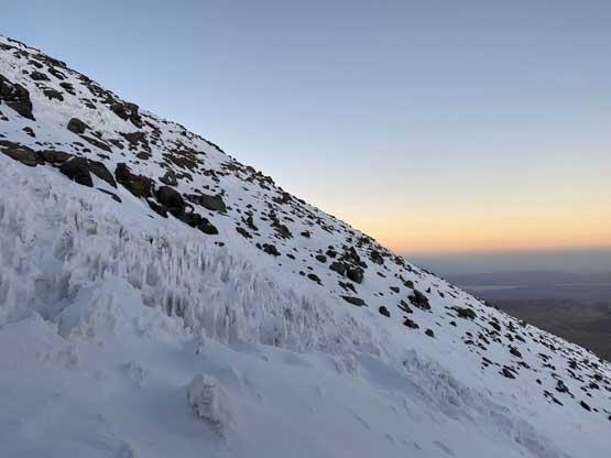
Dusk time. Time to sleep
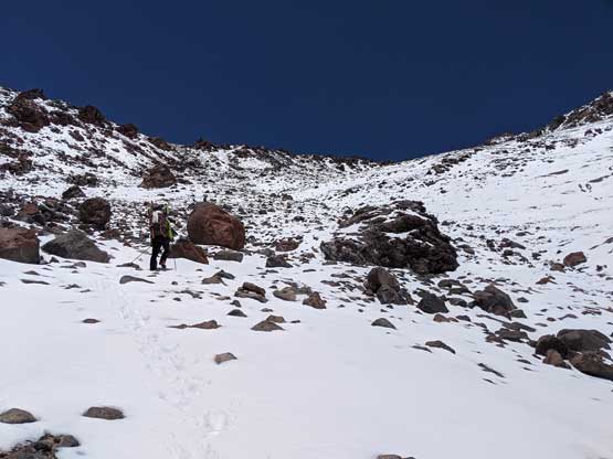
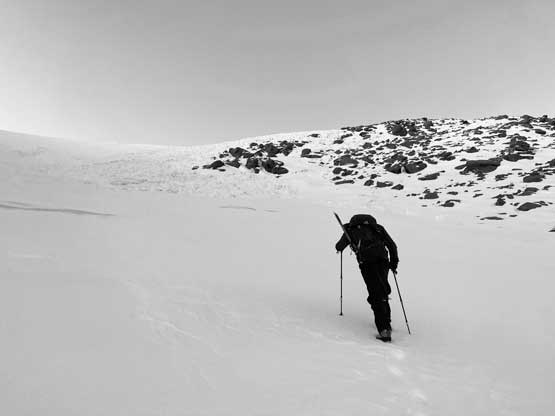
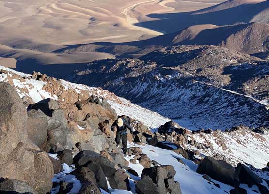
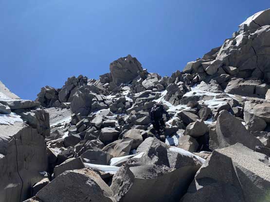
The next morning we spent roughly an hour to get going and once I stepped on snow I instantly knew we were in for some adventure… The snow did freeze but the crust was not strong enough to hold our weight. The snow did not improve as we slogged higher neither and the post-holing was getting knee deep at places. I tried pretty hard to stay on rock or shallow areas but such strategy wouldn’t be possible for the whole way up. As we entered the gully at around 5850 m we were forced to traverse rightwards into the deep snow. The wallowing wasn’t too bad but for once in a while we would sink past our knees. We explored the climber’s right side of the gully but found penitentes buried by 2 feet of fresh snow that were awful to walk on, so traversed left back into the fall line. Thankfully we found some stiff wind slabs that allowed us to walk on with minimal sinking. However, the wind slabs gave way to knee+ deep wallowing once the grade flattened out at around 6050 m. We reasoned that there wouldn’t be any more wind slab further up the valley on the glacier. We had to abandon the standard route, exiting the glacier on climber’s left onto rocks in hope for less snow. Getting onto the rocks required some 3rd class scrambling. We were delighted to find indeed much less snow on the ridge but the scrambling was tedious to say the least. Almost the entire ridge was boulder-hopping intermittent with deep pockets of snow, for 700 vertical meters to the summit. Our progress was painfully slow and exhausting, but at least we were making some progress. Connor and I were also start to cough a lot but with no other symptom of altitude sickness we had to keep pushing…
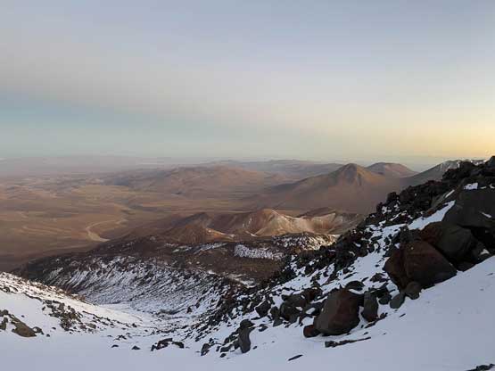
The morning horizon from around 6000 m elevation

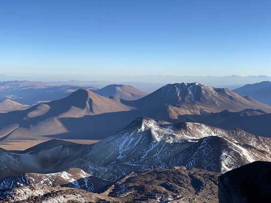
Cerro Inca et al. to the north
Connor tried really hard to find wind slabs to assist our ascent
Penitentes field suggested we were entering a glacier

Bailing the standard route onto rocks
Another photo looking north down at the zone that’s land-mined
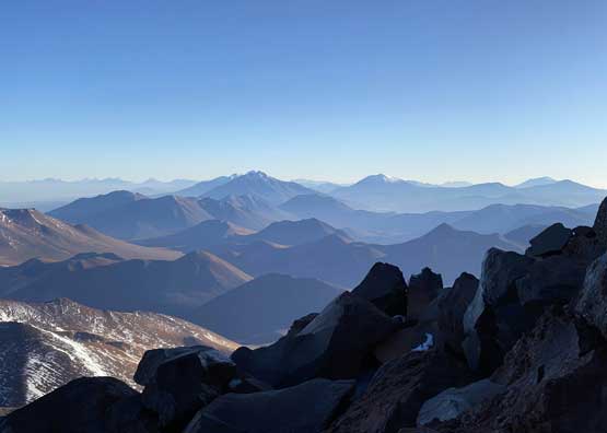
Volcán Socompa et al. far to the north on the Andean crest

Cresting the rocky ridge only to find a shit ton of boulders

This picture captures the typical post-holing…
Connor on one microscopic frame of the ridge. It never ends…
Connor pretends to be happy… At least the view was good

A wider view looking north towards a handful of ultras
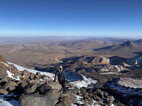
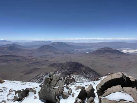
After a long stretch of boulder-hopping that required great care we could finally see the “summit pyramid” with our destination still more than 400 vertical meters above. What appeared to be a “horizontal stretch” proved to be an even-worse battle with boulders covered in fresh snow. Some of these boulders were car-sized and a slip (and injury) would likely mean death in such a remote place, so again our progress was painfully slow. The final 400 m towards what seemed like the summit had less amount of boulders, but the trade-off was more wallowing. I was leading at this stage and the trail-breaking was slow and exhausting. Almost every time I ventured onto snow I would sick more than knee deep. One particular pitch required me to literally dig a trench up the bottomless powder. Connor took over the lead soon and led us to the “summit area”, only to find out what appeared to be the summit was definitely a false one. What appeared to be the true summit was still a ways back there, with nothing but snowy boulders in between. It looked painfully miserable, but at this point we did not have a choice but to embrace the misery, even though our coughing weren’t getting any better. I led the first half of the scramble carefully dealing with every single chuck of rock while Connor led the final 3rd class step onto the summit. Thankfully this time we were indeed on the true summit, which was confirmed by the register.

What appeared there was the false summit, that we found out later

Connor wrapping around a huge boulder
After a while the sub-summit finally became smaller
We had to stay on rock or shallow area whenever possible
Connor leading the last bit of boulders to the true summit

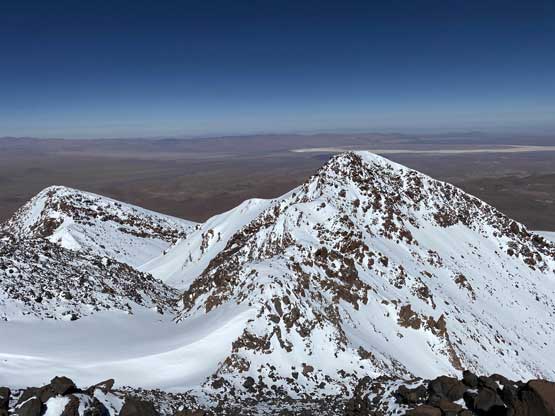
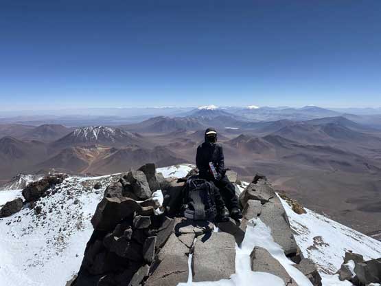
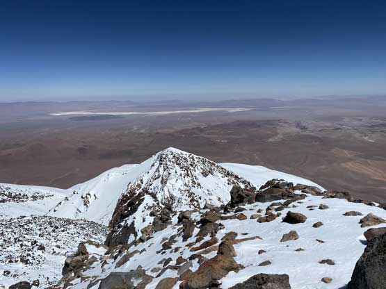
Summit Panorama from Volcán Llullaillaco. Click to view large size.
The typical views. The view wasn’t that good from the top.
Connor on the summit of Volcán Llullaillaico
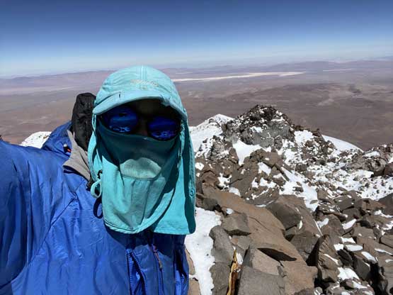
My summit selfie…
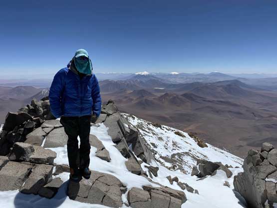
Me on the summit of Volcán Llullaillaico, the 7th highest in South America
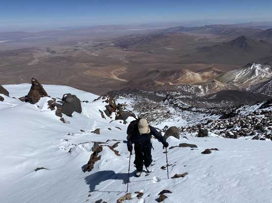
We lingered on the summit for about 20 minutes to regather physical and mental strength but given our physical conditions and symptom of sickness we had to get down fast, even though the terrain would not allow us a fast descent. The down-scramble from the summit back to the false summit was probably the most dangerous section of the whole route. The next 400 m plunge was much faster but just as dangerous as we both discovered a lot of holes in the snow. We then reversed the bouldery ridge step-by-step, for at least an hour. My plan was to just “deal with it” and reverse our route all the way back to camp but Connor suggested to bail onto the glacier and post-hole. Connor was done with the boulders but I said I wouldn’t have the energy to wallow thigh deep snow at this point even though it’s downhill, so Connor had to lead it. The descent to the glacier involved a lot of steep shits on either snow or loose rocks but the downhill faster made it possible. Connor hoped to find more wind slabs but such stayed as just a hope. There was no wind slab whatsoever. I watched Connor sinking past his knees on almost every single step forward and reluctantly followed, only to find out I would sink even further on top of his tracks. On average I sank thigh deep but occasionally I would post-hole down to my waist. The fact we were descending on a glacier covered by fresh snow made me feel like discovering a crevasse a couple times, but checking my footings I soon realized were actually descending on a penitentes field, except for the penitentes were covered by 2-3 feet of fresh snow… The next half an hour or so was totally fucked up and I swore a ton. One sudden thigh-deep post-hole had my shin smashed onto the icy crust resulting in some bleeding. I didn’t know how long I still needed to swim in this shit. Connor was far ahead out of sight at this point and I had to take one break to regain focus. Thankfully once rejoining our ascent tracks and descending back into the gully at 6000 m the going became significantly easier, although still very shitty. Another hour or so later I limped back to camp like a totally drunk guy.

Starting the descent
The sub-summit was still far below us

Connor taking a break from the boulder-hopping

We opted to bail onto the white shit here

Connor plodding across the glacier with brutal post-holing
I was exhausted but I said right away that we had to descend to the truck and drive down to the refugio on this day. I was still coughing and I thought for sure liquids had accumulated in the lungs and spending another night at 5550 m wouldn’t be wise. I thought about packing up right away but Connor suggested to take an hour break for food and water. Since we would finish one day ahead of schedule I cooked my Mountain House dinner as a luxurious lunch meal. An hour later all of our shits were packed and we took a fast plunge down the slushy snow to 5200 m where we finally ran out of snow. The rest of the descent back to the truck was fast and uneventful. The trail-head transition was fast and fluent and we were soon on the roads, and another hour later we were down to the empty refugio enjoying the luxuries. We got here in the “early evening” hours with at least one hour till sunset.
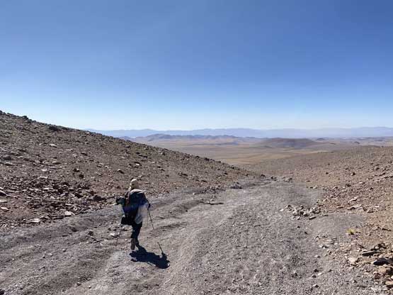
Descending the dry gulch

A review shot of Volcán Llullaillaico. What a hard won summit…
While resting and cooking in the refugio we made plans for the next few days. We still had 4 days till the end of this trip and we wanted to climb another 6000 m peak. I had some doubts as I was still coughing, although not as severely, and I was mentally drained from the shitty conditions we just encountered on Ojos del Salado and Volcán Llullaillaco, and we for sure would encounter more snow in the nearby regions. However, the weather was simply too good to resist. The only ultra in our vicinity that had a “trail” to the top on my Gaia map was Volcán Pili, more than a hundred kilometers to the north but required one day of driving to get there. We could not short-cut the drive and must go almost back to Antofagasta and then drive all the way past Calama to San Pedro de Atacama, then up towards Chile/Bolivian border. We estimated this to be a long day of travelling so set the alarm at 7 am. There’s no rest for the wicked, and our trip continued with an ascent of Volcán Pili aka. Acamarachi. And of course it would end up being much harder than what the Gaia map seemed to suggest….
