Viennese Peak
August 9, 2020
2074m
Chehalis Area / Harrison West, BC
The “Chehalis Group” in the West Harrison area is known for the rugged terrain and quality alpine rock climbing and Viennese Peak is one of the harder summits in this group with no “tourist route” to the top. The easiest route from Viennese/Recourse col goes at an old school grade of “class 4” that roped climbing is likely required even for competent parties. The higher quality and more commonly done option is the east-to-west traverse. The east ridge has one pitch of 5.8 near the top and after reaching the summit, climbers will descend the west ridge to Viennese/Recourse col and resume the ridge traverse over Recourse Peak to Mt. Clarke, completing the classic “VRC Traverse”. The term “classic” here is only relative to the local climbers living in Fraser Valley. Climbers from outside the loosely-defined region of SW BC will probably not drive all the way here for this trip because much of the terrain is “type 2 fun”. There’s significant amount of suffering and route-finding required for just a couple pitches of climbing. Even getting to the trail-head is complicated with several confusing link-ups of logging roads. In the modern era the driving direction is easy with the aid of GPS technology but one still needs a vehicle that can handle 40-km (one way) on rough roads.
I had been eyeing on this group of peaks for a couple years and my plan had always been to tag them individually by the easiest routes. In that case the hardest section would be the west ridge of Viennese Peak. Earlier in this year I started to reconsider the route choice. I talked to at least 2 or 3 climbers and with no exception, the only route that they were interested in was “VRC Traverse”. I figured that if I didn’t have to lead that 5.8 pitch I should be fine. The decision to pull the trigger was a random and last-minute one as usual. While driving back home from Mt. Warren in the Rockies I received some texts from Lily Q. that a window had formed. While stopping for food in Clearwater I checked the weather and immediately confirmed the Sunday-Monday plan. This also gave me one day of resting at home, that I would greatly appreciate. We both knew the rough idea of what to expect and we had about 24 hours to research but I was still at least 8 hours away from home. Lily is one partner who I trust the trip planning and for this particular trip she did more homework including talking to a few friends who’s done the route and requesting a GPS track from Jeff H. about Mt. Clarke’s descent that was also the scramble route. I of course, double-checked her work that before going for the trip we both pretty much had already memorized each of the individual stages without having to further consult with beta. We did bring a bunch of beta photos in our phones just in case. The plan was to do the “full ridge traverse” option as illustrated in Steph Abegg’s trip report. It’s slightly longer but involves less route-finding in the below-treeline zone.
Our plan was to break the trip down into two days. We would not carry a tent nor sleeping pad. We’d aim to go as far as we could on the first day and just shiver through the night somewhere on the ridge. We figured that to do this whole traverse in one day wasn’t impossible, but would be extremely unpleasant and also risky in the way that we would be forced to solo everything but the 5th class pitches. At around 5 pm I picked her up from New Westminster in my trusty Tacoma and three hours later we had turned onto the Mystery FSR off the main Harrison West. The roads were in a rough shape with millions of pot-holes and washboards that the driving with extremely slow. There was surprisingly no vehicle at the trail-head but the pull-out wasn’t large enough for a comfortable car camping, so we drove a little further and found a nice spot on a spur road. The night was humid as expected.
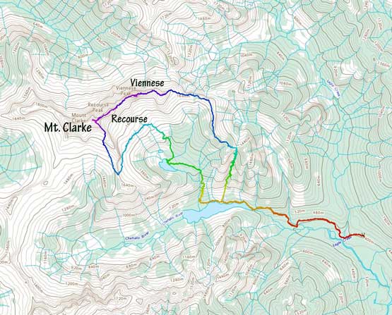
Viennese, Recourse, Clarke Traverse. GPX DL
The next morning we woke up in dark and aimed to get going at around the first light. The hike to the lower Statlu Lake was fairly confusing if it’s in the old days, but now with the aid of GPS tracks all we needed was to check the phone zillion times. There were a shit ton of junctions and most of them were unsigned. None of us did much research about the approach section so we relied 100% on the GPS to get us to Statlu Lake. The trail was as “good” as it could get for this part of SW BC. The path was easy to follow, but the terrain wasn’t very pleasant – up-and-downs, boulder fields, overgrown sections, log bridges, etc. The bush was thankfully not very wet. We contoured around the Statlu Lake for about half of its length to the base of the gully that would eventually bring us up onto the ridge. This gully was reported “very tedious” and “full of boulders”. I agreed with the latter but didn’t find it to be too unpleasant. Before going off-trail I spent some time ditching the trail-runners and swapping for Trango Ice Cube mountaineering boots.
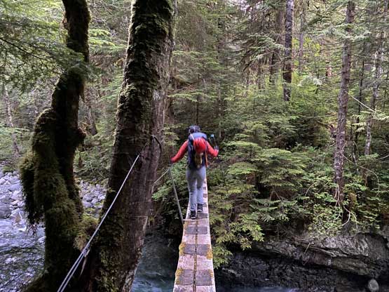
A hiker’s footbridge crossing Eagle Creek at the start

After a while we came to an old logging road

Plodding up this logging road to pretty much the end

A cairn indicated we had to bail the road onto a much-older road

The condition on Statlu Lake Trail was pretty typical for SW BC

Not the most enjoyable trail but at least it wasn’t a long one

Arriving at Statlu Lake
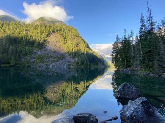
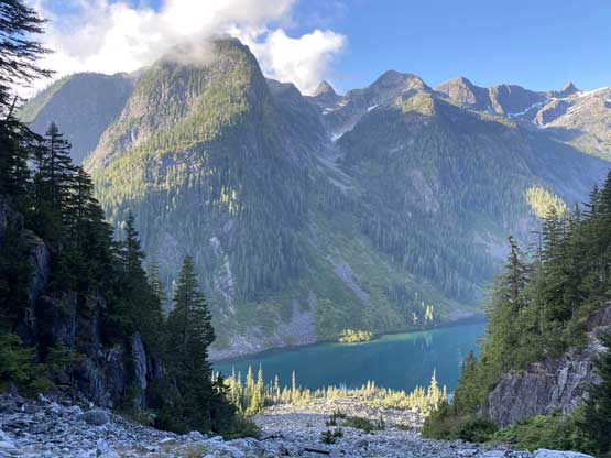
Statlu Lake itself is a worthwhile destination

The trail crosses this boulder field while contouring around the lake
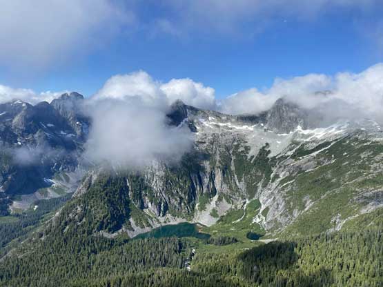
The gully ascended over 600 vertical meters so the view’s very foreshortened. The lower section did have a ton of large boulders (some of them loose) but in a short while the boulders had become mostly talus that we no longer needed to pay full concentration. This section also gave some cool and unique views of Statlu Lake and the north face of Mt. Bardean so we didn’t find it being boring. The upper gully did seem to drag on forever and the rocks had become more loose. We were hoping for a sitting platform at the col for a break but that place was shaddy and full of mosquitoes so we turned left and kept going. The next 200 m gain was probably the most unpleasant of this “full east ridge” of Viennese Peak as we had no choice but to bushwhack. The brushes were wet but thankfully not wet enough to soak our boots. We had to frequently apply the technique of vege-belaying to haul ourselves up some steep and slippery stretches. The ridge finally mellowed out once the bushwhacking’s over and we found a nice spot to finally take a food break, although the weather wasn’t as clear as forecasted with low clouds coming in and out.

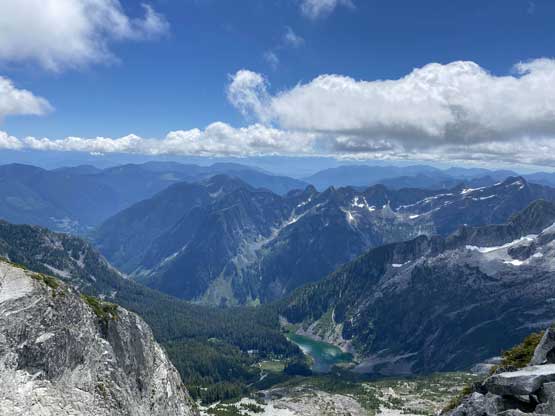
Looking down at Statlu Lake and Mt. Bardean
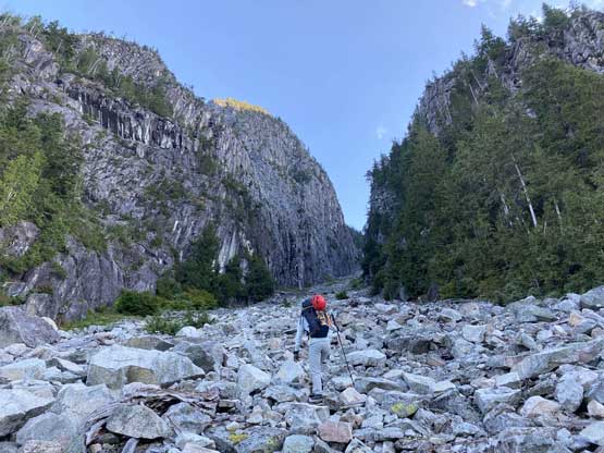
Lily entering the constraint of this long ass gully
Another photo of looking down at Statlu Lake, from higher up

The upper reach of this gully was extremely foreshortening

Immediately above the col we had to bushwhack. This section was wet

The bushwhacking was intense for short periods of time

Vege belay and patience was the key

Finally exiting the short bushy stretch.

The north face of Mt. Bardean looming behind…
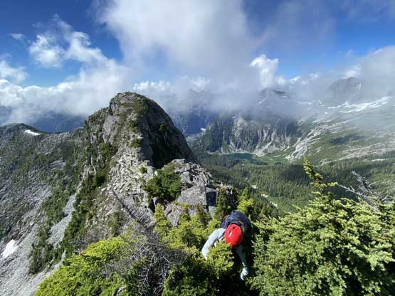
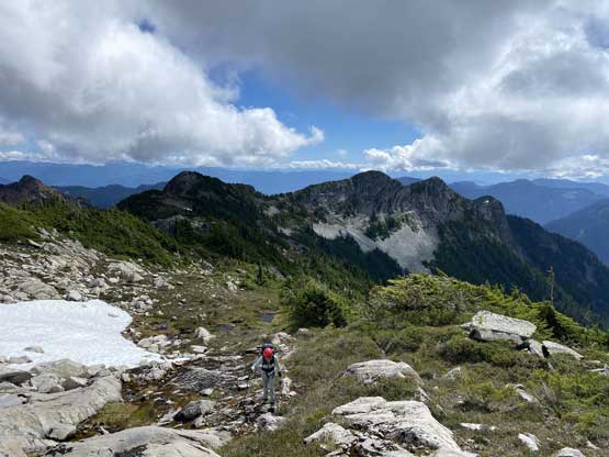
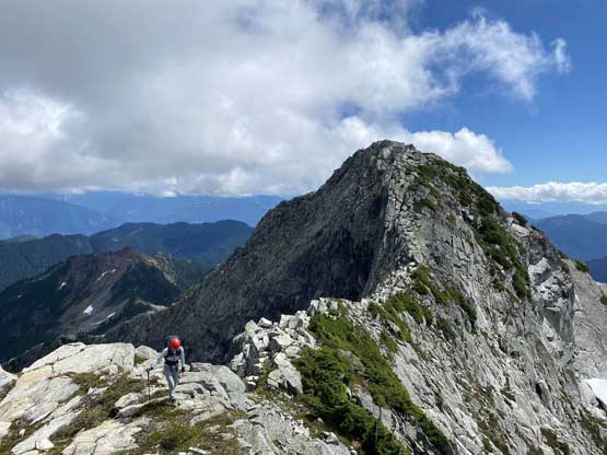
We then easily traversed over a couple small bumps. There then came one major tower that involved fair amount of exposed class 3 scrambling. We stuck relatively close to the ridgeline to solve the problems. The section from the exit of the 600-m gully to the base of “Peak 6500” had taken us longer than expected so that we took another long food/energy break. The scrambling up the east ridge of “Peak 6500” was fun with some route-finding on 3rd class terrain, and then we descended fairly easily to the start of Viennese Peak’s east ridge.

Lily on one of the bumps
This is looking down towards the upper Statlu Lake

Me on one of the bumps. Photo by Lily Q.

Traversing ahead towards the next, semi-technical bump

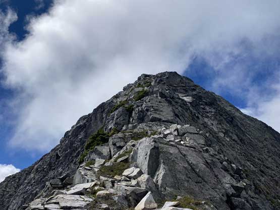
Me approaching this imposing tower. Photo by Lily Q.

Lily starting the exposed scrambling on the south ridge of this tower
The scrambling was bushy at places

From the tower, looking ahead to “Peak 6500”
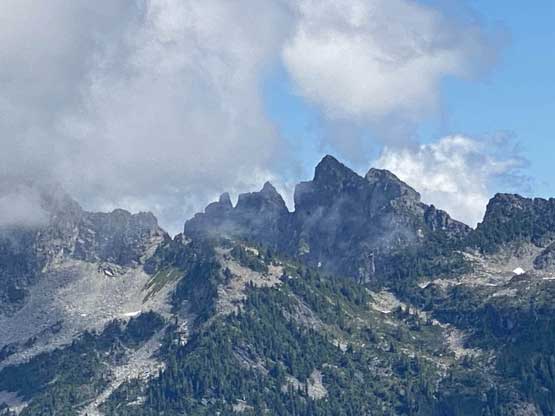
A zoomed-in view of Trio Peak in Trio Creek drainage
Plodding towards “Peak 6500” now on easy terrain
The east ridge of “Peak 6500”. Lots of 3rd class and route-finding
Lily scrambling up the typical terrain

Higher up on “Peak 6500” looking at Nursery Peak
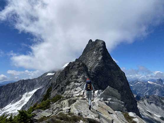
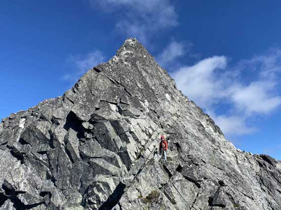
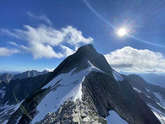
Viennese Peak finally ahead. It looks imposing…
Looking back at the bump of “Peak 6500”.
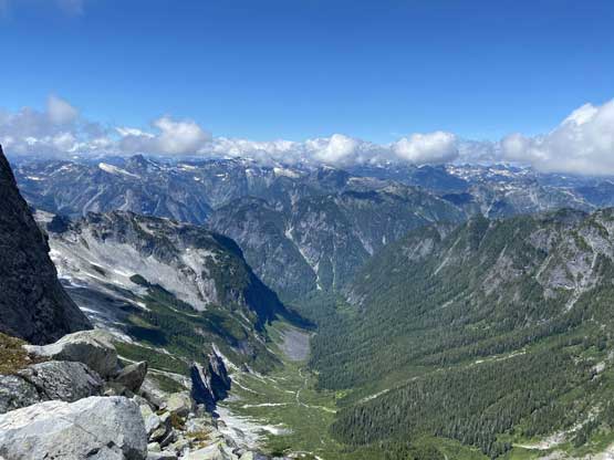
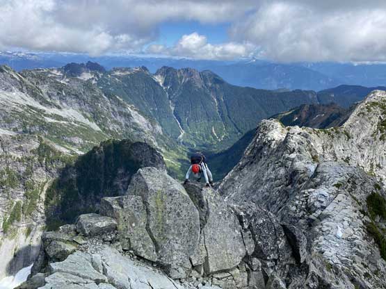
This is looking down into the remote Winslow Creek valley
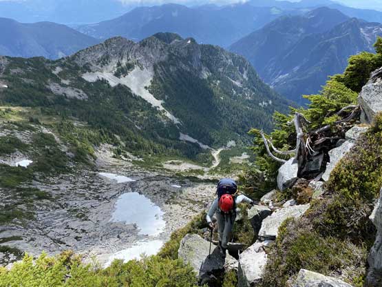
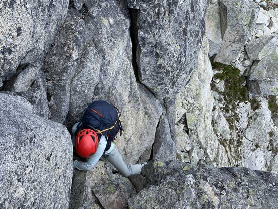
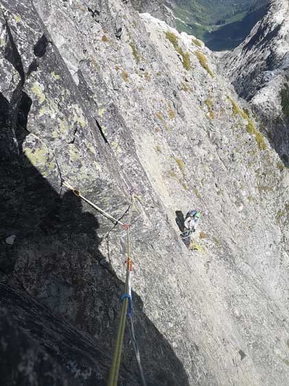
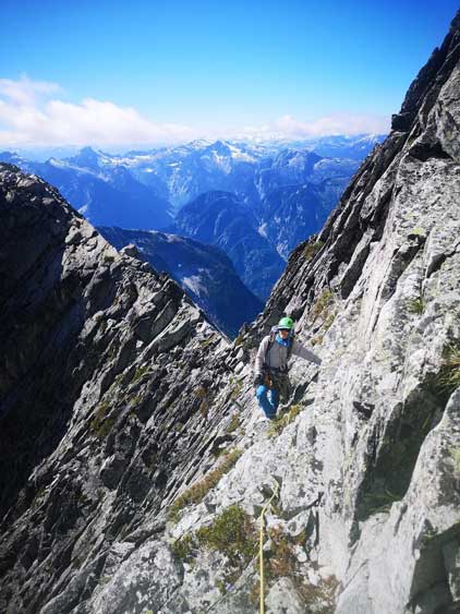
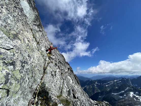
The east ridge started out fairly easily and steepened to more class 3 with occasional class 4 steps. The challenge really did not come until 20 m under the summit where we were forced to traverse an exposed ledge out climber’s left. In retrospect we should have donned gears and swapped footwear for rock shoes earlier on easier terrain. Now we were directly under the technical pitch and were forced to do a very awkward gear transition. The ledge was no wider than 2 feet with deadly exposure. We had nowhere to sit and had to make sure to not drop any gear. The transition took at least 20 minutes. We then built a trad anchor and Lily led the pitch. She opted to lead without a pack as it’s 5.8 and wasn’t very obvious. It was very confusing as where exactly to aim for whether from her perspective or from my position so she basically had to just figure it out. The climbing was legit 5.8 so to climb with two overnight packs wasn’t an easy task for me. On a traversing spot I stepped out, instantly blew a foothold and took a pendulum fall (with a top rope belay). I was a bit shaken but had to resume the climb. There’s one short layback crack that I had to grab a cam as an additional handhold. There was one more slabby crux section with very small holds higher up that felt again, very taxing. I could climb 5.8 in the crags but with two packs weighting probably over 50 lb in total this felt next to impossible. After this pitch of climbing we were pretty much on the summit of Viennese Peak.
Lily plodding ahead towards the east ridge of Viennese Peak
One of the trickier steps on the lower ridge
Looking down south past Upper Statlu Lake
Lily scrambling on some exposed terrain on the upper ridge
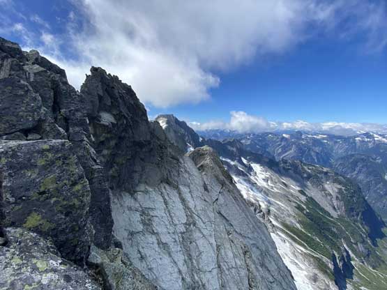
Looking sideways across the uppermost north face of Viennese Peak

More scrambling on the upper ridge. It’s getting more and more airy

This is the summit block…

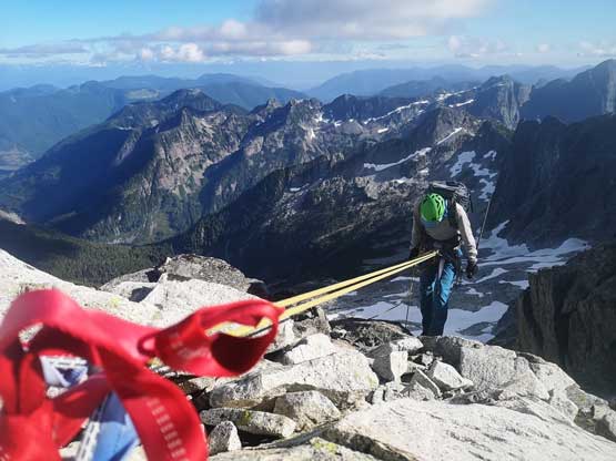
Traversing down onto the exposed ledge
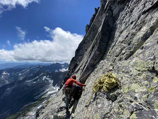
Here at the base of the pitch Lily set up a trad anchor and sorted the rope
Me belaying. Photo by Lily Q.

Partway up the 5.8 pitch. Looking up

Summit Panorama from Viennese Peak. Click to view large size.
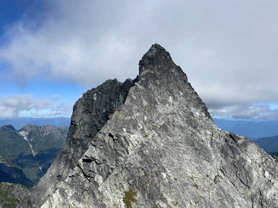
Lily searching for the rappel anchor with Mt. Clarke ahead

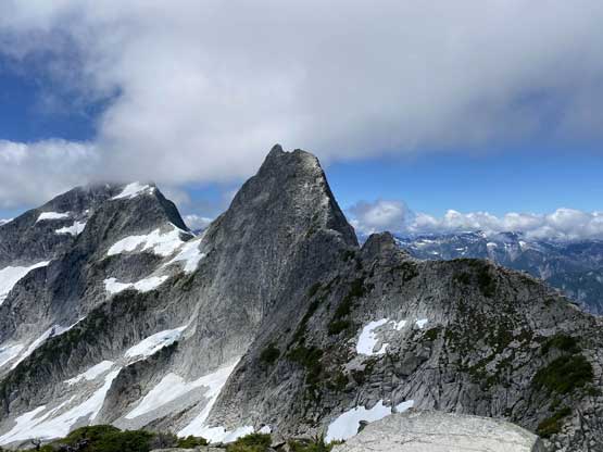
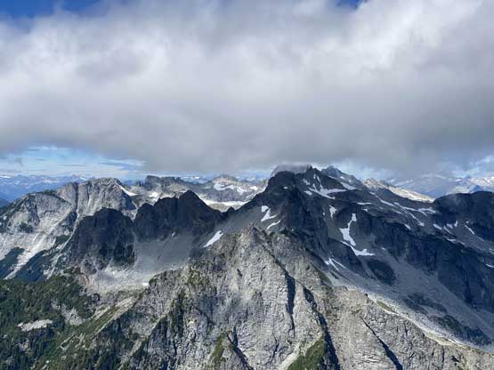
Mt. Bardean, Mt. Ratney and Stonerabbit Peak

Could even see Harrison Lake. The Old Settler behind
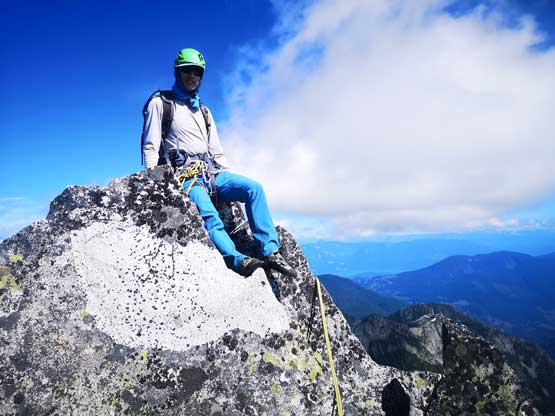
Me on the summit of Viennese Peak
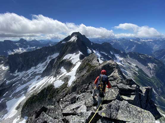
We correctly located the anchor that Jeff/Alastair used on their trip, as well as another anchor a bit down the west ridge that Gilberto et al. used. When Lily gave me these beta I felt very confused. It took me a while to realize there must have two separate rappel stations on or near the summit and our on-field observation now confirmed that. We opted to use Gilberto’s station on the west ridge as they would significantly shorten our traverse/down-climb below the rappel. I led down the rappel to the correct diagonal ledge and decided that it’s safer to belay across instead of scrambling across. There was a good boulder to sling around for an easy anchor-building and then I led across the ledge, slowly and carefully. It wasn’t difficult and I could have gone faster but I wanted to kick down most of the loose rocks as we were not rushed in time. There were also plenty of cracks to put in gears so we both felt very safe. After the ledge Lily took over the lead over a couple knife-edge aretes and then we unroped for a while of scrambling. There was one more additional rappel immediately above Viennese/Recourse col. I knew from Jeff/Alastair’s trip that we should look for a rappel station for that step, and there sure had one. At the col, we took a long break filling up water from a residual snow patch and then resumed the traverse over Recourse Peak.

Me leading down the summit block rappel. Photo by Lily Q.

Lily rappelling off the summit block
Me leading down the exposed ledge.
Lily having some fun time belaying me across this airy ledge

A zoomed-in photo of Lily on the ledge after I finished
Lily and the upper west ridge of Viennese Peak

Looking north past the upper west ridge into more Chehalis terrain
Grainger Peak is the highest in Chehalis Group
Another shot of the upper west ridge of Viennese Peak

Lily scrambling along the middle section of the west ridge.
Me on the second rappel. Photo by Lily Q.

Lily rappelling the lower step

More scrambling followed that rappel
Recourse Peak ahead with the late-afternoon sun

More fun scrambling on the west ridge

The clouds finally dissipated revealing more rugged terrain

Lily at Viennese/Recourse col heading for Recourse Peak
