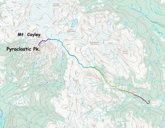
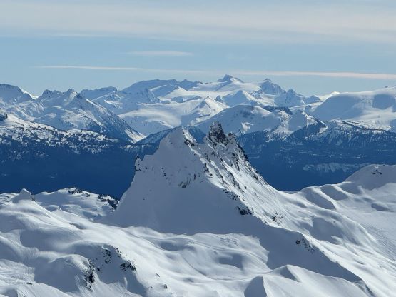
Pyroclastic Peak
February 9, 2024
2349m
Whistler, BC
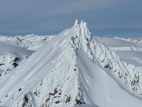
“Pyroclastic Peak” is the unofficial but descriptive name of the second highest peak on Mt. Cayley massif. This isn’t a sub-peak as it boasts over 100 m prominence as well as a very distinct profile. The entire mountain is made of volcanic conglomerates and can be deemed “unclimbable” in summer conditions. In fact, this peak has only two confirmed ascents, both in the 1970-80s according to Francis Bailey’s research. Two more accounts in the recent era were dug out on Instagram but I could not find sure evidence that the true summit had been made. That coastal culture behind “why wouldn’t you post and talk about your achievements” is still difficult for me to understand, as I grew up in a completely different culture that’s all about “who is who”. In any case, none of these ascents were documented with details so “Pyroclastic Peak” remained as one of the greatest mysteries in Sea to Sky’s peak-bagging. I knew it’s doable and I had been considering it for 8 years ever since my first foray into the zone in April 2016, but I was never able to pull the trigger. I anticipated some similar terrain and overall difficulties as Atwell Peak and such ascent would require all stars to align nicely. I was not off by much.
The winter of 2023-24 had been warmer than usual which created more precipitation events in the form of the wet and sticky “spring snow”, as well as freeze-thaw cycles. The overall snowfall amount was far below average but for me, it was more about the question “how much snow had actually stuck on that steep face”. Contrary to most, I actually thought this might be a great year for steep faces like this so I had been closely watching the weather windows. That perfect window happened on last Friday and I decided to drop everything at work to go for it. I had been mostly planning this ascent with Francis B. and Chris G. but they were not able to pull the last minute trigger on a weekday. Their proposal was Saturday but the weather forecast was not as bomber. Elise and Mel on the other hand, had Friday available. The plan was eventually made for me to go with Elise and Mel on Friday, and Francis and Chris would follow up on Saturday if we were able to summit. Based on my past trips in that area including the ascent of Mt. Cayley’s true summit I knew there’d have reliable cell reception up high so we could communicate easily. I inquired the access situations by asking the Powder Mountain Snowmobile Club, and got firm words that the road was currently drivable to “4 Corners”, about 5.5 km up from the usual winter parking. This finalized the decision to approach from Brandywine (east) instead of Shovelnose (west). The round trip distance would be around 30 km so a day-trip should be sufficient enough. I had also talked to ski guides including Evan Stevens who had been writing the weekly snow reports on his Zenith Guide page, to triple check my thoughts about this being the “best window in recent years”.
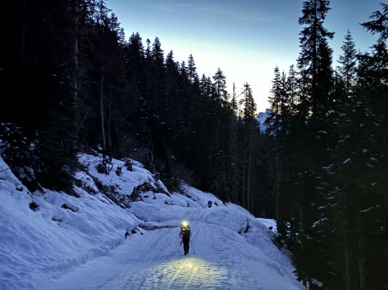
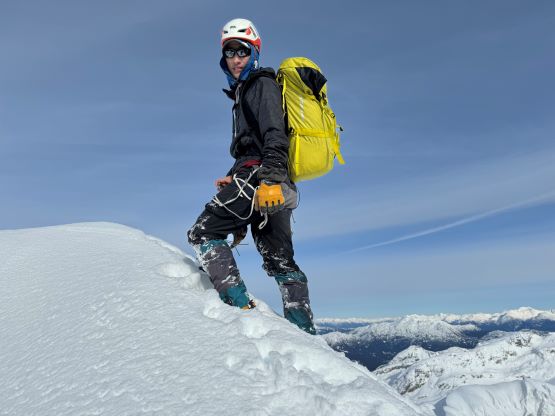
In terms of gears we would bring everything as if we were going to climb Atwell Peak so our packs were about 30 lb each. That’s a tad heavy for a day-trip but I actually don’t think we could have done much better. We could have left the ice screws and trad gears behind as we only encountered one pitch of mixed climbing and that was unprotectable, but that’s about it. We also made the hard decision to wear mountaineering boots the entire way just because our packs were already heavy enough. I could not trust the Trango Techs so my only viable option was to wear the Nepal Evos that I had bought in 2017, which I was not particularly looking forward to. Finally it was the decision to car-camp at the trail-head even though it was totally doable as a single home-to-home styled push. I insisted on car-camping because I needed that extra few hours of sleep given the serious nature of the climb. I finished work at 9:45 pm (in White Rock), and Elise wouldn’t be off until 11 pm (in Vancouver), so the decision was to leave Mel’s house in North Vancouver at 11:15 pm. I drove us to Squamish uneventfully and we did successfully get to the “4 Corners” parking on Brandywine FSR at around 800 m elevation. The final few kilometers were on snow but the road had been plowed by the snowmobile club to facilitate access to the “higher elevation snow”. I actually didn’t know why would they plow the road as the Chocolate Bowl was already out for the sledders due to the impassable creek crossing, but I definitely wouldn’t complain. We had the benefit from both having a higher staring point and NOT having snowmobiles zipping around. We could have 3 hours of sleep at most so I played that lazy game and simply laid open beside the truck in my -32 C Western Mountaineering bag. Elise and Mel stuffed themselves inside the truck as they were also not motivated to set up the tent. We thankfully did get some sleep by the time the alarms went off at 4:30 am. We eventually started at 5:20 am.
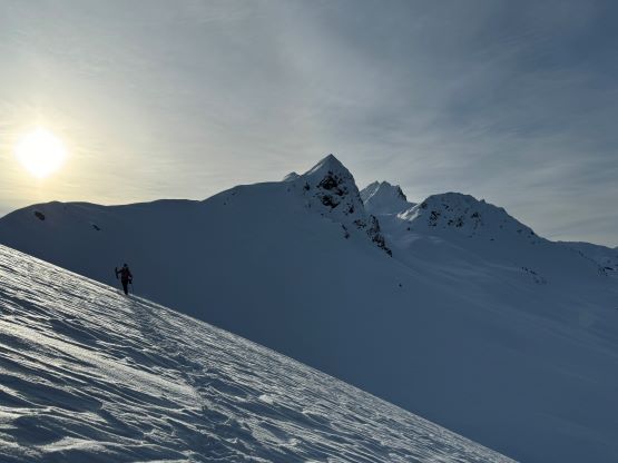
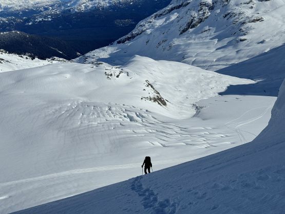
I regretted for not bringing the fatbike as the entire 6 km approach up the snowmobile route into Chocolate Bowl could easily be pedaled. A few steeper sections probably would warrant the use of stud tires but I was sure that the fat tires could make do as well. Nevertheless we plodded our way up on foot and did not need snowshoes until after the creek crossings. It was apparent that the crossings were no longer doable in a snowmobile but a lone skier had made the crossing and we just followed the skier’s tracks. The skier had merged his/her tracks into the old snowmobile tracks minutes after the crossing but we opted to make our own snowshoe tracks by ascending a line straight up the slope. This would significantly shorten the distance. Meanwhile we had some amazing sunrise views behind on the horizon. The trail breaking was heavier than I thought though as there were more than 30 cm of fresh, dry snow sitting on top of the old surfaces, and some of the new snow had consolidated into wind slabs that could not fully support our weight. The slabs were bonding excellently to the old surfaces just like how it was stated in the avalanche forecasts, but post-holing and breaking through the slabs was tedious and tiring.


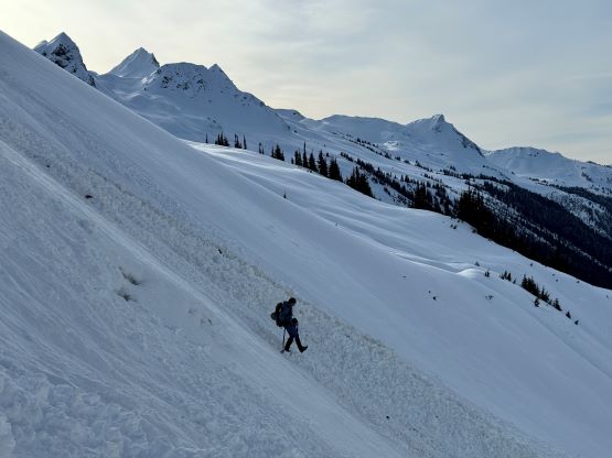
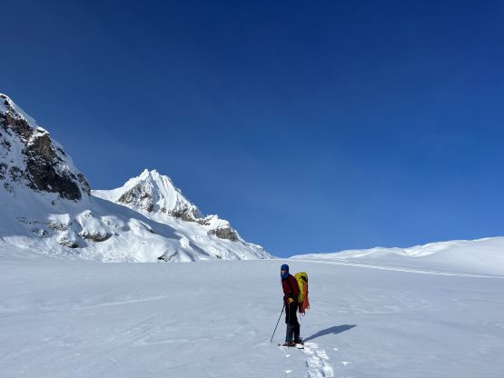
We merged back onto the sled tracks once the slope angle tapered off, and trended climber’s right aiming at the distant saddle, the lowest point on the ridge line between Mt. Fee and Brandywine Mountain. This section felt like plodding across an icefield. The saddle was the high point of the Chocolate Bowl approach and we got our first glimpses of the objective, still laying a long ways ahead. To access the glacier I opted to try the third possible way different than how I did in April 2016 and July 2023, by circumventing the troublesome bump on the west side. The February snowpack should help eliminating the choss and this route has the advantage of being the shortest in terms of distance. So I led out that way, breaking trail while side-hilling. There was about 100 m unavoidable elevation loss, and then we were at the questionable zone underneath that bump. The terrain was harder than I thought such that we were forced to make a few transitions from snowshoes to boot-packing and eventually to snow-climbing in crampons. As much as the complications I still liked this route for being the shortest in distance, so I planned to take the same way back.
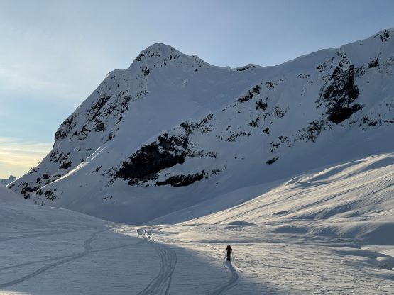

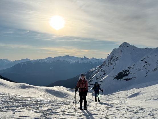


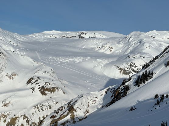
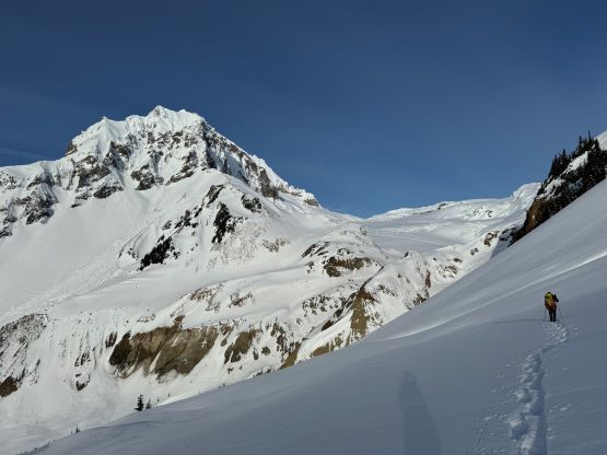
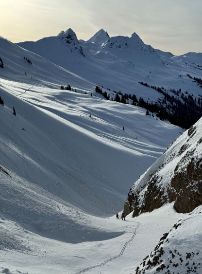
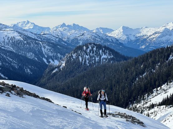

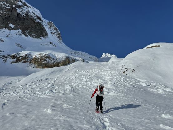
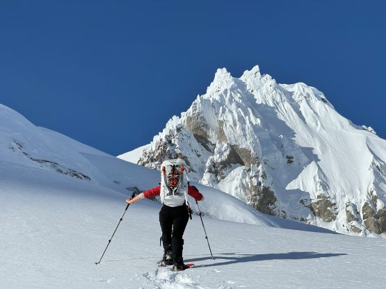
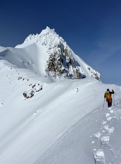
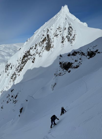
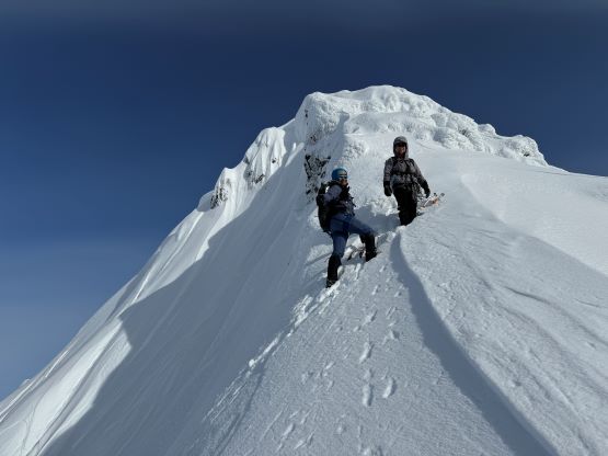
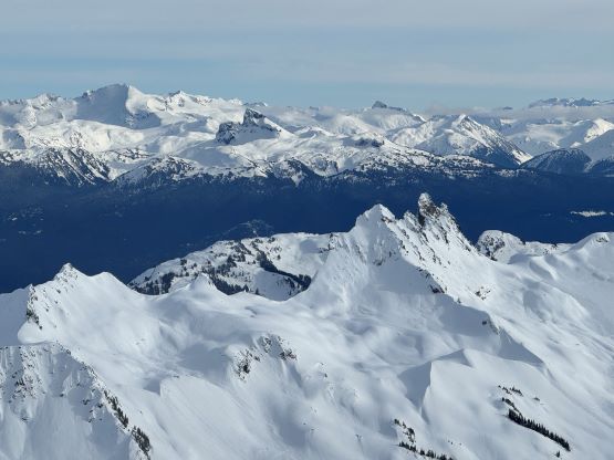
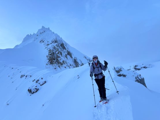
We were about 4 hours into the trip so the approach had taken us longer than I thought. Nevertheless we started the next section, the foreshortening grunt up the broken glacier to the base of Mt. Cayley’s east face. There were a lot more visible crevasses than how I remembered in that April trip but I was able to pick a line to avoid the worst of them. To speed things up we took the risks for not roping up. We also took the same way as how I did Mt. Cayley last summer by utilizing a steeper couloir-ish feature on the far climber’s left. To get into the couloir we did have to ascend a zone of avalanche debris and that was a tad bit annoying. Elise was able to lead through this stretch to offload some of my trail-breaking, and I took over the lead again plodding to the saddle between Mt. Cayley and “Cayley SE1” where we got the head-on view of the formidable Pyroclastic Peak. This view made me wonder what the heck I was signing up for. Not doing much lingering we traversed the connecting ridge to an obvious wind scoop. We took a long break as that’s the only flat-ish spot, ditched snowshoes and donned crampons and harnesses.
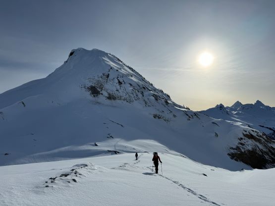


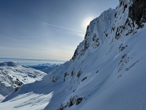


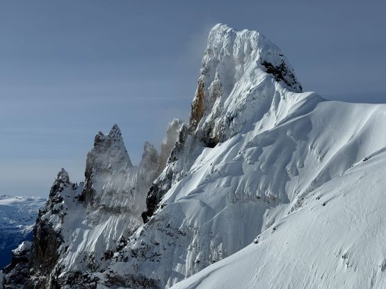

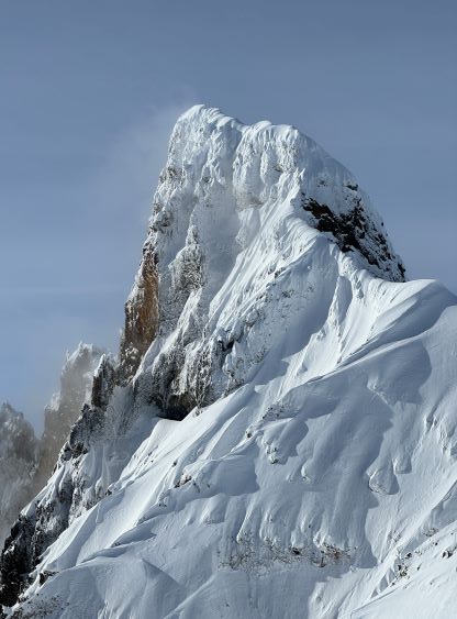
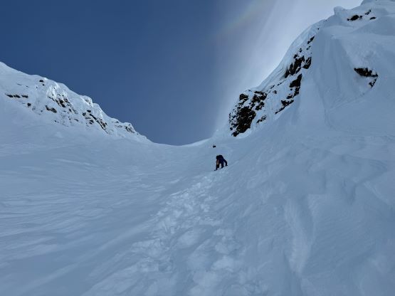
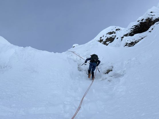
The choss had been well cemented by the snowpack so the ascent of this ridge was nowhere as terrifying as my July 2023 trip. We easily booted and traversed to the next ridge over, and then descended a short ways down to Cayley/Pyroclastic saddle. The terrain beyond here was mostly in the unknowns so I took another deeper breath before carrying on. It wasn’t very obvious as to how exactly should we traverse onto the north face and that necessitated a bit of wondering around. I led a line staying too low, and had to correct the mistake by doing a bit of backtracking. Thankfully I was then able to locate the key couloir to down-climb onto the north face. The couloir was at most 45 degrees and the snow was soft. A long stretch of 45-degree traversing was then followed and the snow condition was mostly soft powder and breakable wind slabs. It was not the “front pointing” as I was expecting, which had made for easier climbing conditions but also elevated avalanche risks. There was thankfully no sign of the wind slabs breaking off, and I also had my fate on the L/L/L avalanche forecasts. Probably because of the wind slabs I led us traversing horizontally instead of making a diagonal way, to get into the main fall line as quickly as possible. This made us skipping the far climber’s left option and positioned us better for the “fall line direct”. My previous research showed the better way could be up and around on the left (which was confirmed by Francis and Chris on the next day), but now we were in for a direct attack, which looked fine to me as well. It would be very steep no matter what.


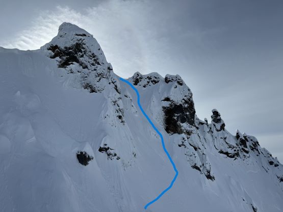


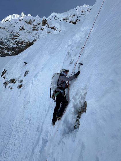
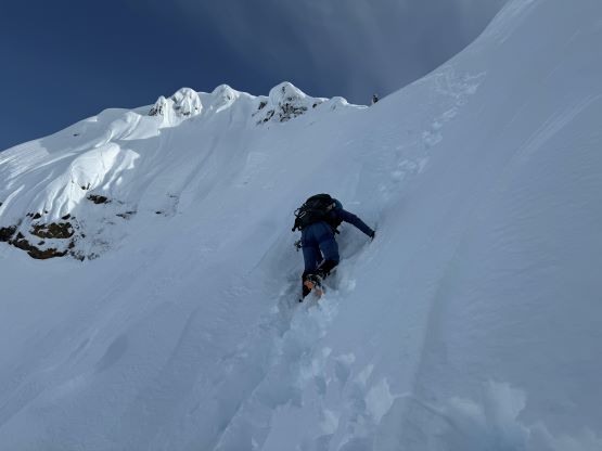
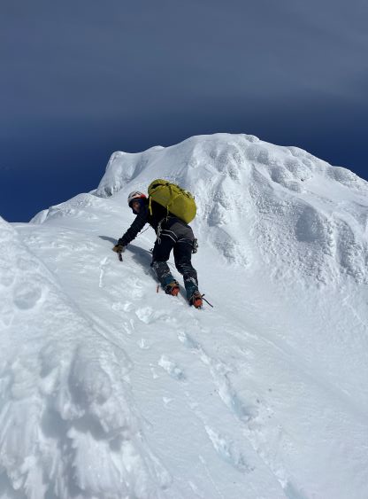
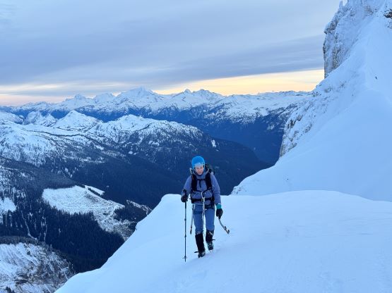
We climbed this lower north face couloir as quickly as possible to a wall of 70 degrees snow faces. This was the lower crux of the route and was much harder than it looked from below. I nevertheless boldly led out, gingerly finding the scarce ice tool placements. It took me a long while to figure out the 10-15 moves but I succeeded in the end. The pitch of ice/rime/mixed was definitely on the upper limit of what I would consider soloing and sucked a lot of energy from me. I took another deeper breath, climbed a few more meters of steep snow onto an arete feature, built a deadman using a picket and dropped the rope down to Elise and Mel. I then belayed them up separately, and while belaying Mel up I told Elise to go ahead and break trail up the upper north face to the col. This upper face was also steep (45-55 degrees) and the snow was also loose and variable. Elise did an excellent job route-finding by staying mostly on climber’s right but merging leftward towards the top across several runnels. Elise and Mel were also able to climb efficiently such that after packing the rope I was no longer able to catch up until the col, and I was climbing as quickly as I could. The top-out was definitely in the realm of 55 degrees and the down-climbing could be a bit intimidating a few hours later.


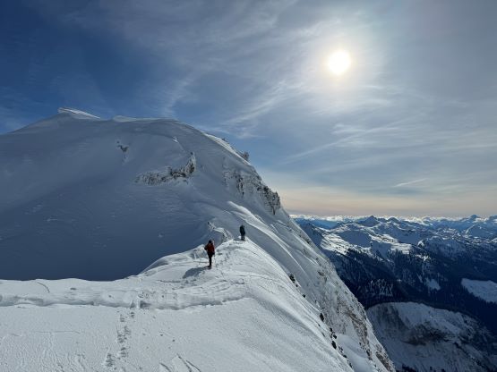
Elise waited for my arrival to lead the SW Ridge to the summit as this section was the most unknown of the entire route. I was diggin’ the hell on the internet but couldn’t find a picture. That skiers’ group had likely stopped here and none of their photos indicated that they had gone further, and the ridge was definitely no joke. The terrain immediately ahead did seem reasonable so we resumed the soloing mode, but as soon as I stepped out on climber’s right to bypass any obstacle the exposure would become severe. A fall anywhere here would mean 300 m straight down the overhanging south face, and that made me a bit nervous at times. And then there came the final crux, an exposed traverse on the edge of a cornice followed by a 60-degree trenching up chest deep loose snow. Again, I went up too quickly and by the time I realized I was a wee bit too close to the cornice I was already committed to finish the soloing. This pitch was similar to Atwell Peak’s finish in some ways, but easier overall. I was relieved to not see any higher ground upon topping out, so quickly built another deadman anchor and belayed Mel and Elise up. I did not even have a picket in the pack so I just used an ice tool instead. Once everyone showed up I untied and soloed the final meter of snow to the highest ground, and then swapped the ice tool for Mel’s picket to prepare for the rappel.


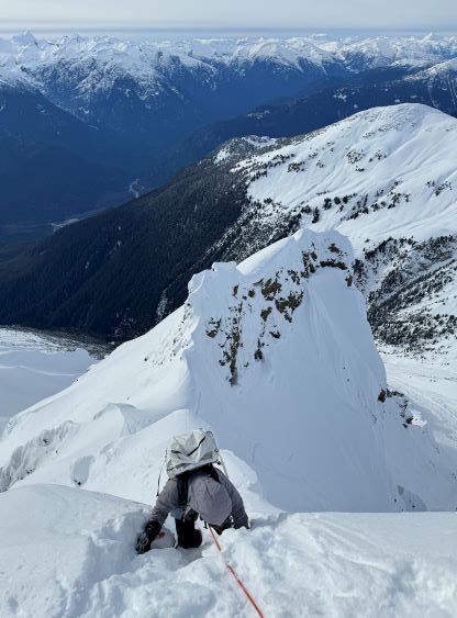

Mel proposed to rappel off a single 60 m strand to avoid any down-climbing on this exposed ridge, so I said that you both should do that instead. Elise was in the better position to lead this rappel, and again she would continue down-climbing the north face afterwards to speed things up. I took the rear end, had to change the rappel back to the double-strand, as well as pulling and coiling the rope from the middle of that exposed ridge. I nevertheless had managed this kind of stuff in some much worse positions so it was okay. I then gingerly down-climbed the lower SW Ridge back to the col and took my time eating some food. Mel was not far below me and was struggling to get purchases down that 55 degrees face, so I was in no hurry. The down-climbing was quite challenging given the conditions that even I had to do multiple kicks before committing to a move, and I did not catch up to Mel until very much at the lower anchor. The picket was left there for our return and we quickly located it. We then did another rappel off the ice/mixed crux and then easily traversed and re-ascended the lower face back to Cayley/Pyroclastic saddle. I was able to communicate with Francis from the summit as well as from Cayley saddle and I encouraged them to come and get it done while the track’s in. We had also left two expensive pickets out there and it’s also better for all 5 of us to share the cost in the end.


We had at most 1 hour of daylight left so we better hurry up. This objective (particularly the approach) was longer than I thought such that we had started a wee bit too late in the morning. We were now in for a long walk out in the dark, but that’s okay. I had also insisted on bringing a MSR Reactor with a full canister of fuel, as well as hot packages of meal for everyone. The plan was to save weight from carrying water and also to have a luxurious dinner with views to celebrate the climb, but we were actually doing okay on water and it was cold enough that we no longer felt motivated to cook. That luxury had then become “contingency”, which I was not very happy about but that’s fine. We swapped crampons for snowshoes and made quick work down and across the glacier. We had to do two more gear transitions to traverse back across that exposed slope around the “troublesome bump”, and needed to take the head-lamps out. The rest of the return was long and exhausting and does not have much worth noting. I finished the round trip in 15.5 hours and while changing, I got a call from Elise that they were down to the plowed section and did not know where the truck was. I guess they were not tracking the GPS but then instead of making them to do the final 200 m of uphill I should just drive down to that spot to collect everyone. This concluded the ascent. Mel and I then took turn driving home and we also stopped in Squamish’s A&W for a deserved meal. I eventually got back to White Rock at midnight. Speaking this objective I think the overall commitment falls short compared with Atwell or Washington’s Lincoln Peak as Francis and Chris were able to find a bypass to avoid the lower crux, but it nevertheless is a serious test piece for winter mountaineering in the region. Keep in mind that this is the easiest possible way to tag Pyroclastic Peak. We did not on purposely seek challenges by doing a summer climb in winter conditions. This peak has to be done in winter as it’s the only possible way due to the unique natures of these volcanic sand castles.


