Mount Smuts
September 3, 2012
2938m
Kananaskis – Smith Dorrien Valley, AB
Mt. Smuts is an impressive looking peak at the core of Kananaskis. It’s also famed to be the hardest scramble in Alan Kane’s Scrambles in the Canadian Rockies and needless to say after finishing most of the other “climber’s scrambles” earlier in this year, I really wanted to tick this one off before winter starts. There are quite a few very detailed trip reports on the Internet and our reference was Bill Kerr’s excellent discussion. With the amount of snow I’d just experienced the day before on Mt. Lougheed, I didn’t really expect a success on this peak. However, Grant (Granticulus) and I still decided to keep our original plan. At least we had Smutwood Peak and The Fist in that area, so there were some back-up objectives if we couldn’t get up Mt. Smuts. As usual, we met really early in the morning, 5:15 am in Canmore, and quickly made our way up the dusty and rough Smith-Dorrien Road.
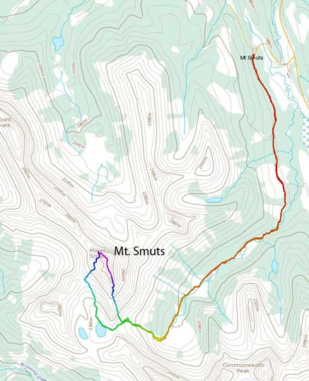
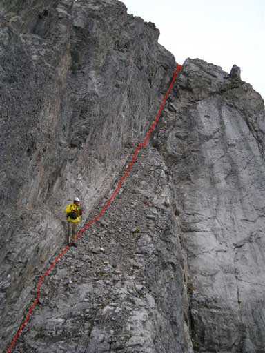
Mt. Smuts standard scramble route. GPX DL
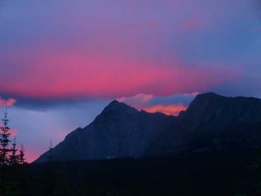
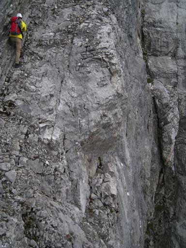
By the time we started, it was bright enough so we didn’t need to use headlamp. The approach went by very fast. It was overcast and dark, so we couldn’t get distracted by the views. There weren’t any good view neither. Actually, except for the NW Ridge of Mt. Birdwood and the SW Ridge of Mt. Smuts, I didn’t get any good view at all during the entire day due to the bad weather… Anyway, we made to the base of the big hill in 1 hour.
Morning view of Mount Galatea
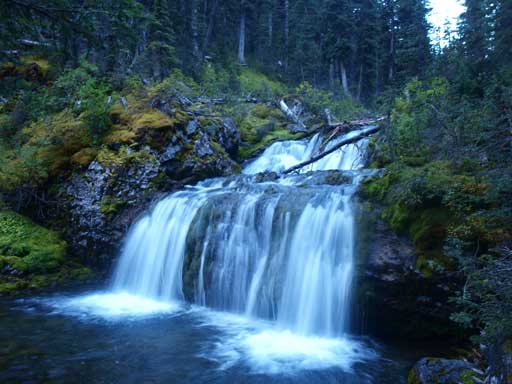
Almost everyone takes a photo at this waterfall, Commonwealth Creek
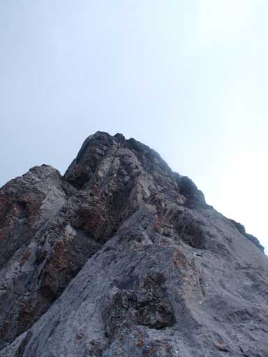
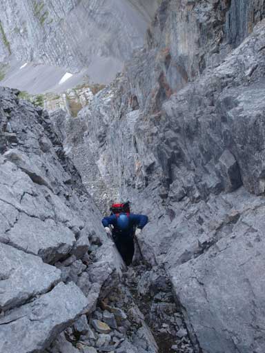
Once we started the big hill up Smuts Pass, Mount Birdwood started to look more and more impressive. I’d definitely want to get up it someday. Grant was a little worrying about the wind and he was right. Once we topped out above the trees and staring at the scree cone, we got pushed around by the strong wind… Oh well, Smuts is mostly chimney climb which gets less affected by wind, so we kept going. Trudging up the initial scree cone was tediously tedious. It’s the worst part of the ascent in my opinion, but thankfully, it was short. We soon made to the infamous staircases. And I have to say, this section was so good and yet so long. We ascended the staircase all the way to the end where we couldn’t go up anymore.

Grant walking up the infamous staircases
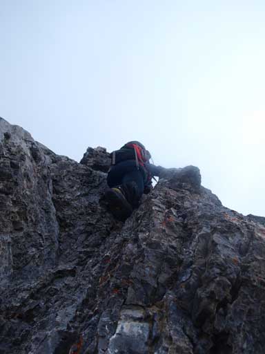
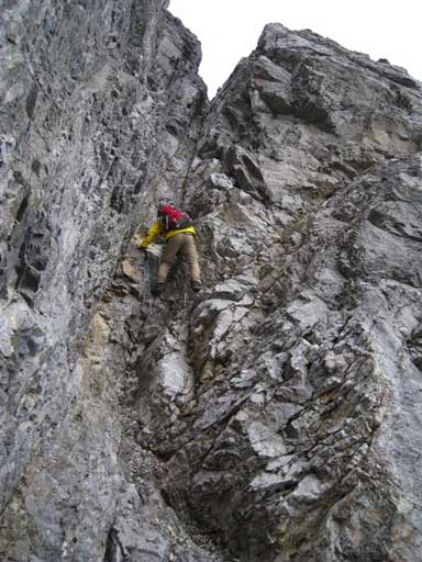
A cairn on climber’s right side indicated we had to cross over to the ridge crest. I have to point out here, the correct way to go is to cross over further to the obvious gully/chimney rather than ascending the ridge crest. We made the mistake of ascending the slabby ridge. I did realize the mistake and managed to cross to the chimney when I encountered a high angle slab. I would appreciate climbing shoes to ascend comfortably. I did brought my shoes but based on other scramblers’s trip reports, I shouldn’t encounter anything that requires climbing shoes. To get to the chimney was also quite tricky as I had to use very small foot holds, friction holds, and finger holds to traverse about 3 meters. Grant went straight up that slab section (well, he’s done Northover without climbing shoes so he’s good for this). However, he did get some intense moments on that route (rated as 5.5). The chimney I took (on-route chimney) got steeper and steeper and near the end, it got almost vertical. The exposure is real here and the climbing is very difficult. We both made through our own lines. By now we had done what’s so called “Step 1”.
Looking up the ridge from just topping on the crest
Grant scrambling up the typical terrain on this ridge

Me traversing into the correct gully. Photo by Grant
Me scrambling up Step 1’s gully

Grant, on the other hand, kept challenging the direct ridge line

More exposed slabs on the direct line.
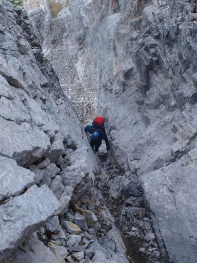
The “Step 2” involved two separate chimneys, with the second one involving one tight 5th class move (according to our reference on summitpost). Both of them are on climber’s right side of the ridge crest and should be clearly spotted. To get to the 2nd chimney, we had to cross a downsloping exposed scree covered slab ledge.. We used extra caution on our footings here. Upon arriving at the crux move I chose to squeeze in and pull up use arm strength. Grant chose to firstly ascend the ridge side, which was probably easier but much more exposed.
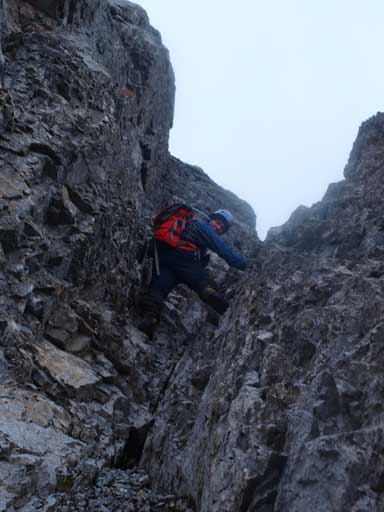
Grant starts Step 2

Grant with Mount Birdwood behind
Me finishing the first gully on Step 2
This picture shows the exposure on the ramp traverse
Me traversing the sloping ramp
Me starting the second chimney on Step 2

Me nearing the top…

Me climbing the crux move on this chimney
Grant challenging the crux step on this chimney
Same as above.
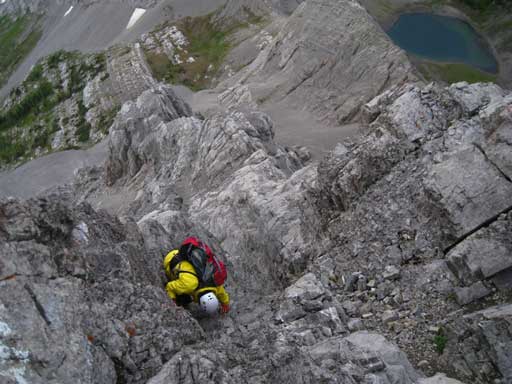
After this bit of excitement, the hard part on the ascend route was over. We could took a deep breathe. It was very cold and windy and we quickly made to the summit. There’re exposed places on the ridge but nothing serious.
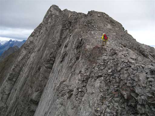
Me traversing the final summit ridge. Photo by Grant
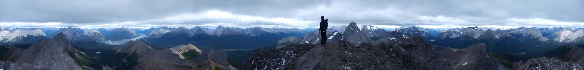
Summit Panorama: Click to view large size

Panorama of Burstall Pass area and the distant Royal Group

Panorama of Spray Lakes area
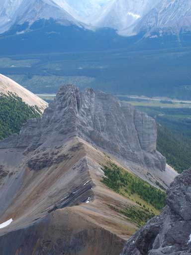
The Fist seen from the summit
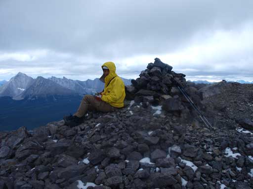
Me on the summit
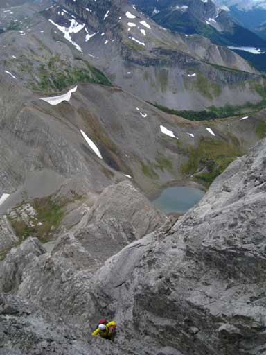
We didn’t stay long except for eating one sandwich, simply because of the coldness. I should have taken out my copy of Bill Kerr’s excellent instructions, but to some reason I didn’t. I thought the descent gully would be obvious… I made a huge mistake by taking the first obvious gully down. It got steeper and steeper near the bottom and the last 2 meters was very technical due to lack of holds. However, this step wasn’t exposed as it’s a chimney climb. I could just jump down this 2 m but I chose to down-climb it. If the gully didn’t work out and I was forced to backtrack, it would have been at least “interesting” to climb back up this step. Grant patiently watched me getting down this steep gully but he didn’t follow as he would knock down rocks to me. Further down, the terrain gave me a bit of break but then became steep again. I managed to get down for a while but the gully soon became over my comfortable level. Thankfully the slabs on the skier’s left side were doable. I “crab-walked” down these slabs and got back into the gully again. I crossed the gully and got to the infamous series of ledges… Now what, I realized my mistake of taking a wrong gully down, as the way I had to traverse was towards skier’s right. (If you take the correct one, you have to traverse skier’s left)… Oh well, I carefully down-climbed these ledges and got back to safe terrain. Looking back, I couldn’t believe that chimney is doable… I waited Grant for 15 min and he came down the correct one. I guess I discovered a new route down Mt. Smuts. But I really hope I won’t make any mistake like that anymore.

Me descending the wrong gully. Thankfully it eventually worked
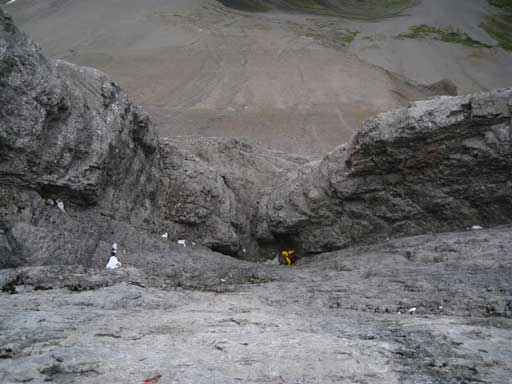
Nearing the bottom of this wrong gully

Back to easy terrain now. “Smutwood Peak” in front
Scree run brought us to Smuts – Smutwood col. The weather didn’t show any sign of improving. Assiniboine area was already soaked in and we decided not to do Smutwood Peak. We want a blue sky view of the NW ridge of Mount Birdwood. On the way back, we passed several groups of hikers, as well as fresh bear droppings…
Now, I’ve done Mount Fox, Kiwetinok Peak, Fisher Peak, Wapta Mountain, Mount Northover, and Mount Smuts in just over 1 month. They’re probably the most serious ascents in Kane List, and here’s my thought and ranking.
1. Mount Northover: slab face climb + ridge climb. Severe exposure and very technical crux move
2. Mount Smuts: chimney climb. Lots of serious hands-on, complicated, and lots of route-finding. Much harder descend as well.
3. Wapta Mountain: techinical and vertical rock band for 20 meters
4. Fisher Peak: 2 big down-climbs; 2 smaller down-climbs. Less technical than Wapta but as vertical and exposed.
5. Mount Fox: 600 vertical meters of difficult scrambling with a harder crux step. Less technical than the others.
* Kiwetinok Peak: Steep and exposed snow traverse, serious route-finding on the upper slope. It’s the snow that makes things harder, so I can’t compare it with the other 5. I felt it’s the most serious among these 6, but skiers might feel it’s the easiest. There’re more mountaineering elements in this ascent.
Northover and Smuts look similar and sound similar, but once you’ve done both, you’ll find they’re totally different. They test your different skills so you can’t really say because I’ve done one, I should be good for the other. On your 1st try, they are equally serious. On the 2nd try, of course Smuts will be much easier as you don’t need to do route-finding. Let’s keep it this way, if I do Northover again, I’ll appreciate climbing shoes for the crux, but if I do Smuts again, I will use neither rope nor climbing shoes.

Hi, Thanks for the trip report. I think the (correct) descent gully (that I used today) is marked with a piton on skiers left and short loop of blue cord. Just wanted to caution people about that piton. I can’t think of any conditions in which it would be safe to use it as an anchor for rapelling or lowering. It is not fully driven into the crack and I could wiggle it with my hand. Don’t use it, please! (Unless backed up with something else) About 50-60m (mid-way) down the gully there is another 2 piton anchor. It looked ok to me. Maybe 50-60 m further down to the traverse point.
I had to rap on the two pitons half way down the descent gully. It was my second time up Smuts, first I was with my normal partner and we didn’t take a rope and had no issues even on descent. The next time I was with my dad, he wasn’t confident with the exposure so I took a rope and belayed him on the two crux steps. In the descent gully (this was late August) it was pure verglas over everything. Super sketchy. Ended up having to rap off those two pitons as the verglas in that section made it impossible to even move. Should have just down climbed the route.
Thank you for taking the time to share this valuable and inspiring information.🙏✌️
Looking for Christine Fletcher who was with Craig Fletcher with whom I have climbed Direttisma on Yamnuska between 1999 & 2001. Are you the Craig? 😁
definitely a hard mountain!