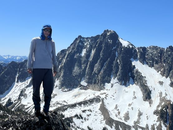
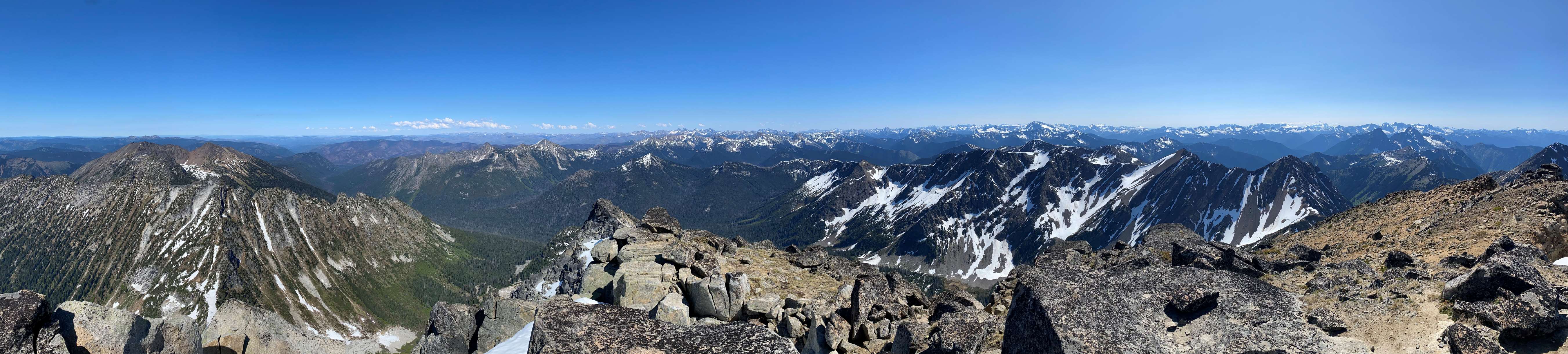
Castle Peak (Pasayten, WA)
June 4-5, 2023
2532m
Pasayten Wilderness, WA
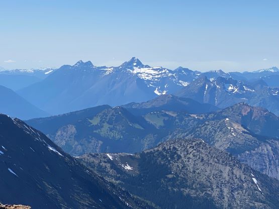
This Castle Peak is the one that locates in Washington’s Pasayten Wilderness close to U.S./Canada border. It has an iconic north face that’s very visible from Manning Park on the B.C. side of the border, but the access is a pain in the ass. There are three published approaches and all of them are contrived and require multi-day trudging for normal parties. The way that completely stays within U.S. requires an expensive boat ride across Ross Lake and hence at least 3-4 days. The two ways from Manning Park are both shorter. Matt Lemke and I had tried the Monument 78/Castle Creek route last year but turned around after encountering 100 dead-falls thank to the apocalyptic flood in November 2021. We planned to bike to the border but with two downed bridges and unknown amount of dead-falls it was not possible. It would then require close to 50 km of hiking with more than half of that distance done in bush and talus, so we pulled the plug as we did not bring camping gears. That left the high ridge traverse from Frosty East being the only viable option. This route is the most technical and requires close to 3000 m elevation gain, but is currently the most efficient for those of us capable climbing steep snow and class 4 on choss. June is the ideal timing with some snow coverage.
Elise and I planned to climb something overnight and I immediately suggested Castle Peak as I saw Connor M. had just logged it in on peakbagger.com. Connor hadn’t written a trip report yet but I inquired the up-to-date conditions so we knew what exactly to expect. The crux had apparently melted out so class 4 climbing would be unavoidable, so I made us to bring a 30-m rope (actually, just a tagline) and a small rack just in case. Brayden joined the team at the last minute. I anticipated that we’d be fast enough to make the summit in the afternoon of Day 1 so we planned an early departure. Elise came over and slept in my home while Brayden would meet us in Abbotsford at 4:15 am. We made to Hope in time for the Tim Horton’s to open (for breakfast), and another hour later we made to the Lightning Lakes day-use area. I did not see any sign saying “no overnight parking” so I parked there. A day later our car was still there so I assume there’s no problem parking there overnight.

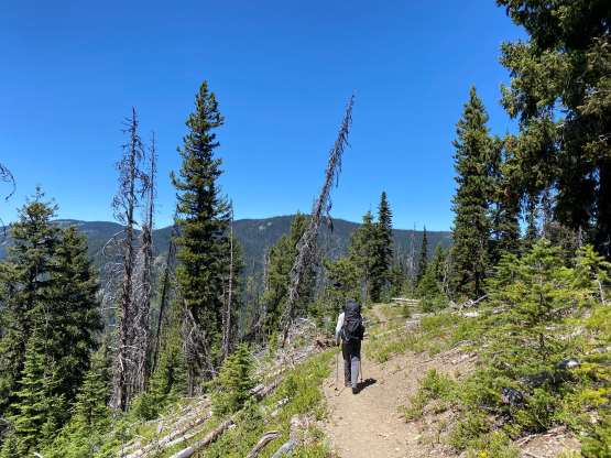
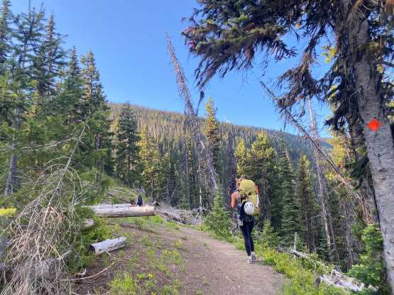
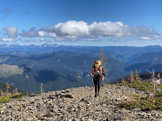
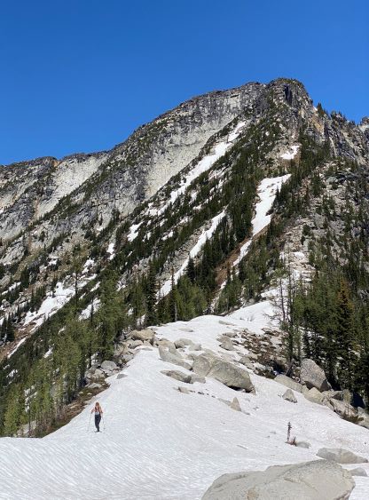
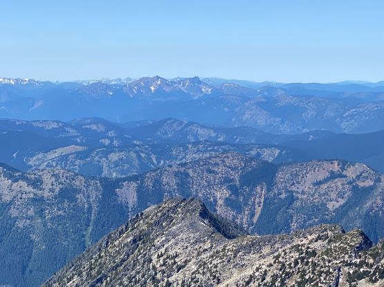
The trail-head is actually on the eastern side of the lake so I parked on the wrong side of the parking lot, adding several hundred meters of walking each way. The trail was also hindered behind some constructions so it took us a while to find it after walking around the lakeshore. Once crossing the lake’s outflow on a bridge we picked up the Frosty East’s trail diverging from the Lightning Lake trail, and the next few hours would then be a numbing plod up this never-ending trail. I was glad that I on-purposely saved Frosty East for this outing as I would otherwise not be stoked to do this approach twice. I had bagged the true summit of Frosty Mountain in 2016 but never bothered to do the sub (east) peak afterwards. This sub-peak does boast over 100 m prominence and is a very popular hike, so it is a legitimate summit. About 2.5 hours later we broke through the forest and ascended a loose slope onto the east ridge, losing the trail several times. I wondered how the averaged hikers do on this section as it requires some balancing on talus which “hikers” usually suck at. I knew we didn’t actually have to go to the very top of Frosty East but I made us to do so, just in case we became lazy on the return. We didn’t stay long as the cold wind forced us to descend hastily.


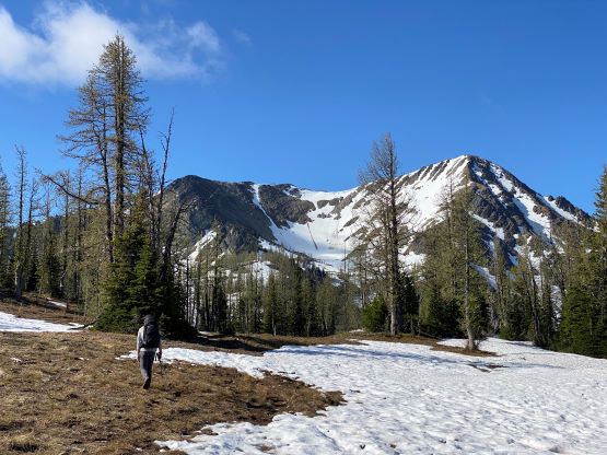

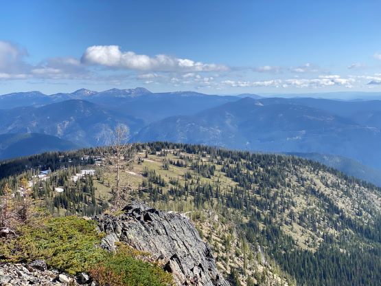


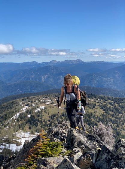


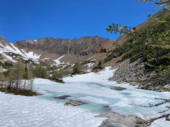
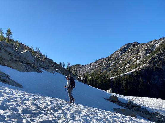
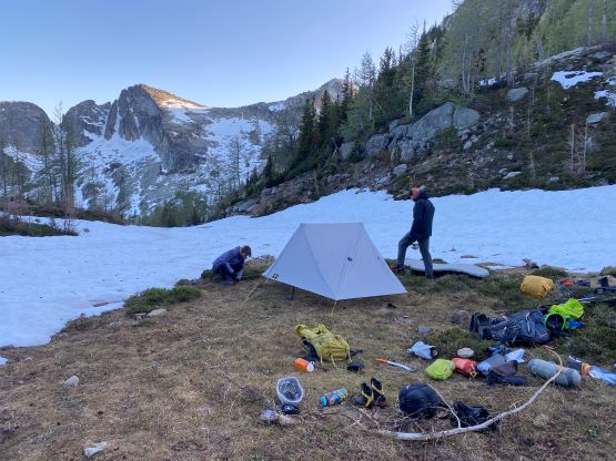
While plodding across the meadows (where people come to see larches) an hour or so earlier I had swapped footwear from trail runners to mountaineering boots as there was still considerable amount of snow. The south slopes of Frosty East however, was not holding any snow anymore. The entire descent was done tediously on talus. The size of the talus was the worst – too small for hopping and too large for skiing. We had to be extra careful not rolling our ankles, especially with the 30+ lb backpacks. Our reference parties (Fletcher’s 2019 trip as well as Connor) had camped on the south side of “Stonghold” closer to Castle Peak but I made the decision to camp on the immediate south side of Frosty East since I spotted some flat spots with running water. I was confidence that we were fast enough to get back to this spot before darkness fell. This eventually made an exhausting Day 1 with over 2400 m elevation gain, but we did eventually get back in daylight. I spontaneously led us descending a short-cut that narrowed into a loose 3rd class chute, which was not to be recommend. This brought us to a tarn that was still frozen. There wasn’t running water but we found a perfect grassy bench to camp a little ways further down. Elise’s tarp tent required a trekking pole to set up but we still needed the pole for the rest of the day, so we just left the shits there open. We even found a rock cave to store our camping food, further reducing the pack’s weight. I was coughing badly as I was still recovering from the recent high altitude climb, but I should be able to tough this trip out.


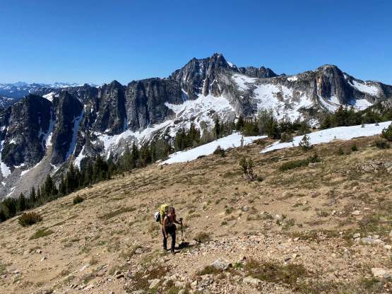
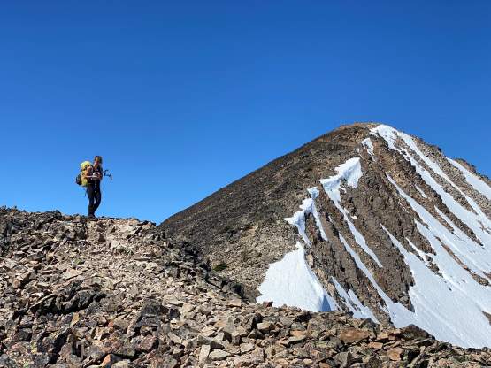
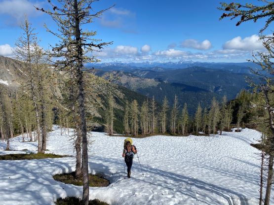
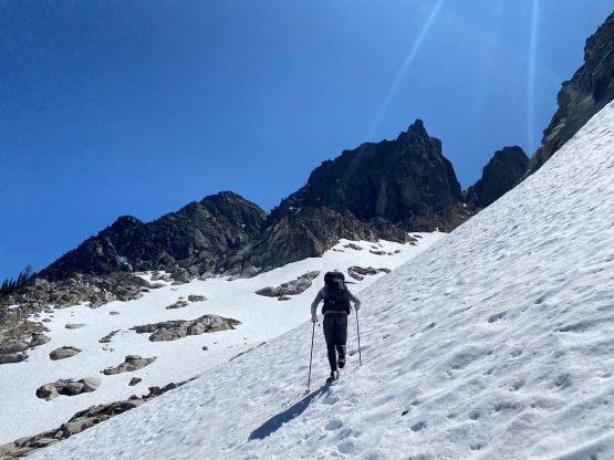
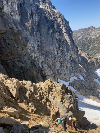
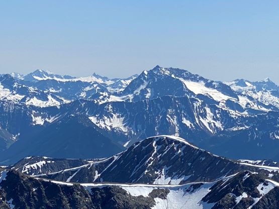
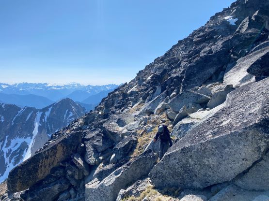
The temperature had warmed up enough that the coldness was no longer a problem. The cold wind was making my ears pain as apparently I was not fully recovered from the frost bites yet. The next stage was a side-hill traverse to the NE slopes of “Stonghold Peak”. The reference trip report didn’t mention this part by much, but I was not anticipating easy times thank to the satellite images. It turned out that the traverse was rather straightforward but some route-finding in micro-terrain was needed. I was mostly able to maintain our elevation without doing too much up-and-downs. On the return we did even better by staying higher above the boulder fields. The transition from this traverse to the snow ascent on “Stonghold Peak” was tedious due to snow-covered boulders, and that’s why I avoided that area on the return. Once the boulders yielded to continuous snow Brayden went ahead, kicking steps all the way up. Brayden exited the snow earlier since he preferred scrambling on rocks, but this made us to do some mandatory class 3+ moves with route-finding. On the descent I avoided all of those scrambling by staying entirely on snow. “Stonghold Peak” has two summits with the north one being slightly higher. The route to Castle Peak traverses up and over the south summit so technically we also didn’t have to go to the very top of “Stonghold Peak”, but we had previously agreed to tag this peak so we must carry on. Again, we likely would get lazy on the return, so we dropped the packs at the col and made a dash for the true summit, right now. It’s farther than we thought with more micro-terrain to content with.


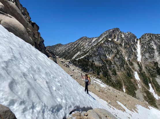
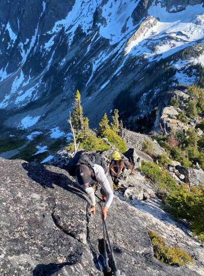
We took another lengthy break at the col between the north and south summits of “Stonghold Peak” before resuming the traverse over the south peak. There was more scrambling on granite slabs. I thought we could possibly bypass the very top of the south summit but that wasn’t the case. We must traverse over the exact top to access the SW Ridge descent. Fletcher had previously named the SW Ridge the “Pain in the Ass Ridge” and we agreed. The terrain was steep, bluffy with lots of krummholz. The route-finding was non-stopping and some big steps and bush-thrashing could not be avoided. Thankfully we did not have overnight packs like those other parties, and we did not have wet conditions neither. We nonetheless made quick progress down, losing more than 300 m elevation to Stonghold/Castle col. The lower half of this ridge was considerably easier, but was still tedious and painful.


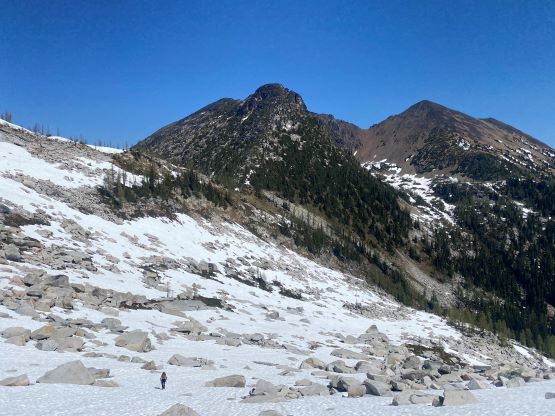
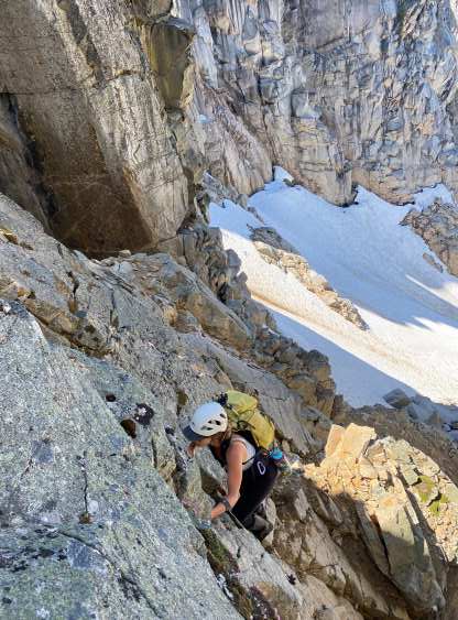
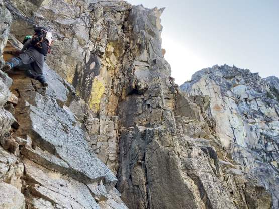
Without doing any lingering at the snowy col we started the horizontal traverse due climber’s left. The plan was to traverse across the pocket glacier to access the obvious “NE Couloir” but I didn’t do enough homework for this stage. I ended up leading us traversing too high. The punishment was two crests of moraine that both required negotiating compact choss with at least 50 m of additional elevation loss. At least half an hour could be saved had we done more thorough research, but at least we did better on the return by staying lower and even found running water to load up the water bottles. Unfortunately there was no running water on the line we took on the ascent, so I was suffering from the lack of hydration for the next few hours. The obvious NE Gully splits into two higher up, and each branch further splits into two constraints. All 4 chutes were melted out, and the “beta” we had was to take the leftmost of the left split, even though that didn’t seem to be the easiest. I’m sure the previous parties all had the same thoughts, and some had tried the other options but regretted. I insisted that we should stick to the known. The snow-climbing only maxed out to 40 degrees since the steepest sections were no longer snow-covered, so we made the right decision to only bring one ice tool for each of us. We didn’t even need crampons as the snow was rather soft in the afternoon hours. To access the crux step we ascended through the moat which was quite “interesting”. The crux was a stiff 4th class challenge with one awkward step-left move that made me pause for a few seconds. I was glad to have brought a rope just in case one or several of us freaked out, even just for mental support. There was also considerable amount of choss below and above the crux step, but that was mostly class 2 and not difficult.


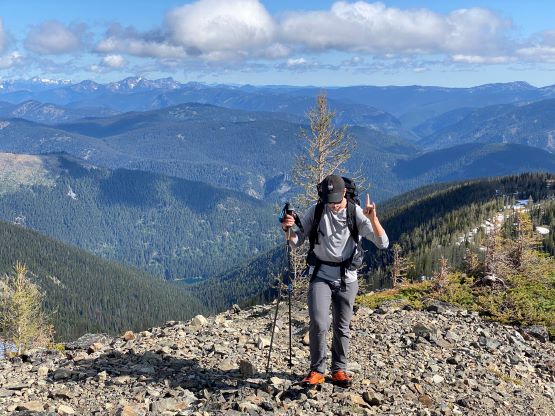
The finishing of this route via SE Ridge was anticlimactic as we just needed to slog 300 m more elevation gain. The lack of energy had finally caught me and now I was struggling to keep up with the pace. I felt like climbing at high altitude again. In retrospect I should have stopped for a food/hydration break but I was being stubborn, making slow but steady progress. There was again, lots of micro-terrain but the route-finding was easy overall. The final traverse to the true summit was trickier than expected. We firstly tried to stay high but encountered some car-sized blocks that required class 4 scrambling to work around. I was too spent to do any climbing at this stage, so bailed off the south slopes, losing at least 30 m precious elevation and found an easier bench to traverse across. This brought me to the south side of the true summit and I then easily slogged to the very top.


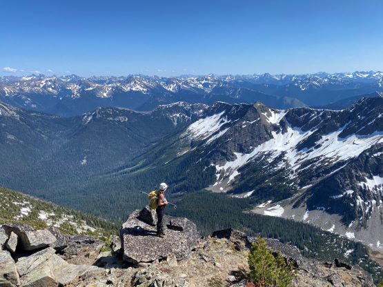


We spent over half an hour on the summit to regain physical and mental strength. I made sure to eat and drink and I finally started to feel better, but the problem was that I no longer had enough water to get back to camp. The only running water we encountered on the entire route was at and below our camp. I anticipated some running water below that pocket glacier so the plan was to traverse lower. I also didn’t bring enough food for this trip. I think for a long while after Everest I have to eat 20% than I normally do, as everyday I was feeling hungry. Anyway since my energy was temporarily back I led us descending hastily back to the top of that NE Couloir. The route-finding was always easier from above so we mostly descended the path of the least resistance. We did not bother with rope work and I actually felt the down-climbing of the crux to be easier than on the ascent. Lower down we easily plunged down the snow gully to the bottom. Brayden and I altered the lead, staying low on the traverse and this worked out perfectly. We found one major source of running water on a piece of granite slab and that saved our day.


After another lengthy food/hydration break we had gathered enough strength to deal with the grueling 300-m climb of that Pain-in-the-Ass Ridge. My energy was now 100% back after the much-needed break. I was still coughing but I felt fine. Several steps on that ridge felt harder than on the descent because we had to literally haul ourselves up. At least one step felt like solid 4th class but I didn’t try really hard to find the “easiest” way. To descend the north slopes of “Stonghold Peak” I aimed for the highest spot where I could accesss the snow slope, instead of reversing the scramble route that we took on the ascent. Getting to the snow involved a few interesting steps and the top section of the snow was rather steep, but this was overall way more efficient. We discovered lots of holes lower down on thin spots near the boulders but that was to be expected. While traversing that side-hill section back towards camp I led us staying higher as the terrain was more open. There was more side-hilling on grass, but less boulder-hopping. We got back to camp with about 2 more hours of daylight but the camp itself was already in shade. It was becoming cold, and we had to set up Elise’s brand new tarp tent. Elise hadn’t even opened the tent so we must figure it out on sight. I ended up reading out loudly the instructions while Elise and Brayden got it set up. I had to bundle myself up in all the layers I brought, and the temperature dipped down to below freezing overnight.


We slept in till 8:30 am when the sun finally came out to warm things up. The sunrise was as early as 5:30 am but we didn’t get direct sunlight until 3 hours later since we camped in a sheltered place. From being too cold to being too hot took only half an hour and then we got out and broke camp. We avoided that shitty short-cut that we took on the way in, by contouring to the south side of that frozen tarn. After ascending the south ridge of Frosty East to treeline I led a rising traversing due climber’s right aiming straight towards the eastern sub-summit and this successfully saved us about 70 m of regain. The side-hilling was very tedious and painful but we could endure that. The rest of the descent of the popular hiking trail was uneventful but boring. After switching footwear back to trail-runners we sped up and got down in 16.5 hours round trip time sans camping, covering over 35 km and 2700 m gain. I then immediately turned on the engine and drove us back to Hope for a much-needed lunch. I ended up spending 30 dollars in A&W, eating one papa burger, one poutine, 5 strips of chicken and one glass of coke and I was still not full.