Mount Olympus
June 22-23, 2017
2429m
Olympic National Park, WA
Apart from perhaps the absolute elevation, the famed and elusive Mt. Olympus (highest peak on Olympic Peninsula hence the highest in Olympic National Park) is one of Pacific NW’s most significant summits no matter how you look at it so that it’s often discussed in parallel with the Washington volcanoes. From a climber’s perspective, reaching the summit of Mt. Olympus is a far more difficult task than those volcanoes and involves a 28 km approach just to get a sight of it, a large icefield crossing and a pitch of rock climb. Meanwhile we are talking about the Olympics – the most precipitous region of the Pacific NW and on top of that, the gigantic massif of Mt. Olympus itself often attracts its own weather. It’s a rare thing when all of the required factors line up in the prime season (late June to early July) and there’s no wonder why most pre-planned attempts end up in failures before even setting foot on the glacier.
Thank to the various types of difficulties to reach the summit of Mt. Olympus is by no doubt a major feat to be proud of. This is what makes Mt. Olympus attractive to me. Fortunately for me I don’t have to “pre-plan” any climbing trip and the unique work schedule allows me to take day(s) off and decide pretty much anything I want at the last minute when it comes to this time of a year. A couple days before the trip I saw a major high pressure ridge settling over the Pacific NW and the stretch of sunshine seemed to last for at least a week. Right off the bat I knew this would be the time to bag Mt. Olympus but due to the mid-week time frame I thought I’d have to solo it. Apparently this didn’t happen that way as Vlad managed to move around a couple meetings to free Thursday and Friday but then added a downside as we must get back by Saturday morning leaving a mere 2.5-day frame Vancouver to Vancouver. Considering the total driving time of 13 hours, the complication with ferry rides and the requirement to obtain a wilderness permit in reality we only had less than 2 days to make it happen. This was pushing it but we like some extra challenges, right?!
In terms of how to climb this mountain I’ve seen a wide range from day-trip soloists running it in 16 hours to massive, complicated guided parties 5-day’ing it with months of pre-planning. Knocking it off in a day sounds specially appealing but I had to be realistic. I’m not a trail-runner and to cover 70+ km without running is not impossible, but certainly pushes beyond my experience and testing my endurance out on such a major climb was probably not the best idea. We had 2 days so why not carrying a camp up there.. After some discussions we decided to try out the idea of “open bivy”, and in terms of other gears we’d go as minimalist as possible. I wish I’m bolder when it comes to rock climbing but unfortunately (or fortunately) I’m not so a 30-meter rope, a few pieces of nuts and cams and a pair of rock shoes were thrown in the pack. It was a dumb decision to carry that much rock gears as the climb turned out to be a fairly trivial “3rd/4th class” as opposed to “5.4-5.6” on some sources, but at that time I had to be prepared for the worst.

Mt. Olympus standard route via Blue Glacier. GPX DL
Vlad and myself managed to leave Vancouver by 6 pm Wednesday evening and our first task was to catch the 9:10 pm ferry ride from Copeville to Port Townsend. The border crossing was without much of a delay. When we got to Deception Pass the lighting was too good to not stop for some photos. It’s worth noting that this was Vlad’s first time travelling west down SR 20 so everything was new to him. About an hour later we got onto the ferry and the timing was perfect for watching the dusk glow on the horizons. The rest of the drive down west along Highway 101 was uneventful in the dark but finding a car camping spot in the city of Port Angeles turned out to be a shit show. We had to move camp twice due to “it’s not allowed to park/tent here” but eventually we did manage to find a peaceful spot high up on Hurricane Ridge road. The delays costed us about 1.5 hours and by 1 am we eventually went to sleep.

The 9 pm ferry ride offered some great dusk scenery
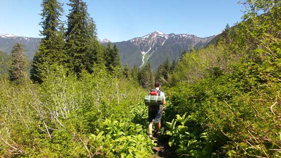
The next morning we planed to sleep in but when the brightness of the daylight arrived it’s hard to keep sleeping, so by 5 am we all woke up. We quickly broke camp and moved down the road and back to Port Angeles. After some morning routine in McDonalds and then Safeway we went to the Visitor Center. About an hour later it opened and we had no issue getting our permit. This was a surprisingly quick process and everything was set by 8:15 am. About 2 hours of driving later we arrived at Hoh River trail-head on the far west reach of Olympic National Park and then the long march began. The first 20 km (12.5 miles) down this trail had very little to document about, but it’s still worth noting that we were trekking through the Hoh Rainforest – largest temperate rainforest in Pacific NW. The trees are gigantic and the biomass are vast (we even saw a fox) and that’s not something we see everyday.

Vlad shows the scale of these giant trees.

As much as the initial 20 km goes. Very monotonous

Olympic Ranger Station at 9+ miles.
Towards the end of this long flat stretch we could see the Hoh River narrowing down into a canyon feature while the trail ascends steeply up the left side bank before dropping down to cross the river. It’s here that the tiredness finally started to creeping in more likely due to the monotonous plod. Vlad finally decided to switch the sneakers to his backpacking boots while the Sportiva Nepal Evos still stayed in my pack. The bridge at mile-13 was impressive traversing 140 vertical feet above the canyon. After this bit of excitement we finally started to gain elevation. The first half this bulk of gain goes to Elk Lake and then the final 2 miles to Glacier Meadows has some rough sections including some steep traverses and that infamous ladder. While everyone seems to like using the ladder I decided to just scree-surfing down the skier’s right side which worked much better. I finally decided to ditch runners and don mountaineering boots at this stage and then we took another half-an-hour break so that I could cook my Mountain House dinner (Rice & Chicken).

Looking down from the bridge crossing Hoh River gorge

Descending the famous ladder at a wash-out
Other hikers wrongly informed us there’s no running water at Glacier Meadows campsite so we filled up all the bottles of ours which turned out to be around 2 L for each. The pack suddenly became heavy again but it beats not having enough fuel to melt snow. Soon enough we arrived at Glacier “Meadows” which wasn’t really much of a meadow at all. There were plenty of running water so I’m not sure what those hikers were talking about.. In any case we kept plodding and after some confusions we got out of the trees on climber’s left side, past a couple more campers and then onwards into a gulch which would eventually lead us to the infamous moraine. The slog up this gulch was tedious and tiring but the first sight of Mt. Olympus massif upon cresting the moraine was inspiring to say the least. Many hikers would push all the way to this point (close to 30 km each way) just for this sight.

Ascending out of Glacier Meadows up this gulch

Cresting the “col”. Keep plodding until it makes sense to get onto the moraine

Looking back from where we gained the moraine

The first sight of Mt. Olympus and Blue Glacier was inspiring

A close view towards the summit of Mt. Olympus.
We certainly did not have much extra time to kill so down the moraine we went. Initially it looked like we could traverse higher and then descend entirely on snow but upon close examination the scree wasn’t bad at all. I have to comment that I’ve ascended more than 400 peaks in the chossy Canadian Rockies so being able to negotiate this type of loose terrain is pretty much a pre-requisite. It took us no time to surf down the scree and then we merged onto snow which was soft enough to just plunge/post-hole down on our heels. Now onto the lower Blue Glacier flats we picked up a set of (faint, melted out) tracks and had no problem keeping a general bearing towards the icefalls. The plod across this lower glacier was longer than we thought and by the time we reached the other side we abandoned the idea of pushing all the way to Snow Dome. There appeared to have plenty of rock platforms about 1/3-1/2 way up towards Snow Dome and we’d set up the bivy upon reaching a “reasonable” site. There were moderate post-holing involved once getting off the glacier but thankfully it didn’t take us long to find a good bivy site.

Descending the loose moraine. Easy if you come from a Rockies background

Almost down to the Blue Glacier flats

Vlad plodding across Blue Glacier

Mt. Mathias

Ascending partway towards Snow Dome to find a good bivy site.

Evening glow on the west face of Mt. Mathias

And, glow on Mt. Olympus. This horn isn’t the true summit though.
There were just enough space to pitch out two single-person sleeping pads. To our surprise there’s even running water nearby so we basically hauled 4 extra kilograms of weight for nothing. Oh well.. During the night the wind picked up. Vlad decided to use my emergency bivy sack which is more like a garbage bag with thermal reflective coating but it did serve as a perfect wind-breaker. Meanwhile my expensive sleeping pad and bag had done a great job keeping me warm and I had no issue getting through this “open bivy”. By 4:10 am the alarm went off, the horizon was already bright, my boots were dry thank to the wind, and despite the warm temperature there’s actually a decent freeze going on. Vlad and I are efficient in the morning thing – as simple as getting out of the bag, putting the boots (and crampons) on and then up we went. There’s no coffee, no breakfast nor any other time-consuming process which I really liked.

Trying out “open bivy”
We picked a more direct line weaving around rocks towards Snow Dome while staying on snow. Thank to the firm conditions we made quick progress with the crampons and about 2/3 of the way up we started to see some morning colours on the horizon. We then picked up the main set of boot tracks ascending steeply towards the top of Snow Dome and upon topping out we were treated one of the most incredible morning alpenglow and then sunrise panorama I’ve ever seen. Hundreds of pictures were snapped but knowing the long day ahead we had to keep plodding.

Vlad ascending out of our bivy site with morning colours behind

The long plod up Snow Dome

Looking back towards Mt. Mathias

Morning horizon over the Straight of Juan de Fuca

The first bit of morning alpenglow on the East Peak of Mt. Olympus

The West Peak, aka. true summit of Mt. Olympus

It’s sunrise time!

Vlad plodding across Snow Dome. “Panic Peak” behind on left skyline

Another shot of Vlad on Snow Dome with incredible scenery behind
Traversing across the upper Blue Glacier was a simple fair of putting one foot in front of another. A couple crevasses were opening up but the previous parties had done a great job route-finding and combining with the firm snow there’s literally nothing to worry about. The routes split ahead but since there’s no track heading up the direct, “4th-of-July” route we’d follow the hordes working around towards Crystal Pass. In no time we were at Crystal Pass and then a steep step later we were on the south side of “Five Fingers Ridge” traversing towards the distant false summit. This stage also had a few big crevasses but the condition was still “early season” meaning the route took a more-or-less direct line. Another mandatory break was spent on the false summit to eat and food and study the last stretch.

Just another shot on Snow Dome. Note the crevasses opening up in the foreground

Another shot of our objective

Can’t get rid of the morning glow views! Looking closely you can see Mt. Rainier

Traversing towards Crystal Pass

Due to the long side-hilling Vlad’s crampons were falling off..

A view looking down at Snow Dome from Crystal Pass

Traversed over Crystal Pass now

Keep plodding.

One of the bigger crevasses that we had to cross

This is the Middle Peak of Mt. Olympus

An outlier of the Middle Peak looks still impressive.

The plod was never-ending.

Another shot of the Middle Peak

Crossing another huge crevasse en route towards the false summit

We were almost at the false summit now.
Descending into the saddle between false and true summits was still mostly on snow, and then up the opposite side we simply used the previous parties’ tracks. The steps were perfect and we got up this 45-degree slope with literally not much effort, and then we were staring at the final pitch. The early-season conditions meant we’d have no problem crossing the moat and the depth of the snowpack might also shaved a couple moves off for us. We managed to reach the belay station while staying entirely on snow. There had a good platform to swap gears and seeing the pitch ahead I decided to not use rock shoes. It turned out to be much easier than described with only a couple “4th class” moves and that’s about it. I put in two pieces of pros in anyway since we had brought them up that far, and then belayed Vlad up. The traverse to the true apex was easy going but the register booklet was completely soaked.

The true summit seen from the false summit

Getting down towards True/False col

Huge bergschrund blocking the exit of “4th-of-July” route.

Easily ascended the 45-degree snow slope out of false/true col

Me going towards the summit pitch. Photo by Vlad

At the base of the north ridge, looking up

Halfway up the semi-technical pitch, looking down.

Vlad scrambling up the pitch

Partial Summit Panorama from Mt. Olympus. Click to view large size.

Partial Summit Panorama from Mt. Olympus. Click to view large size.

Another photo to show the completely-open bergschrund on 4th-of-July route

This is looking back at the false summit. We descended the snow couloir

Mt. Tom is a very rarely-ascended peak.

The south-western Olympics which I’m not familiar with at all

Mt. Carrie and part of Bailey Range to the north

The high ranges to the east – Deception, Mystery, Constance, etc.

The Middle Peak is now lower than us.

The summit register
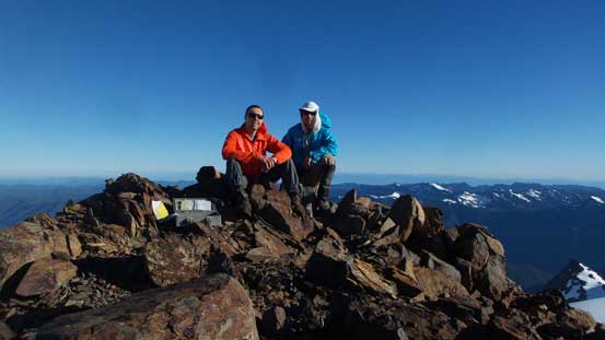
Vlad and myself on the summit of Mt. Olympus

Me on the summit of Mt. Olympus
The views were magnificent with lots and lots of peaks that I had never seen before, but knowing the length of the day ahead we couldn’t linger too long. With only a 30-meter rope we couldn’t do the standard single rappel off the station and instead I opted to belay Vlad down-climbing the whole pitch. I then did a rappel off the anchor hoping to reach as far as possible (I was confident to down-climb the rest if the rope couldn’t reach the lower station). It turned out that the rope was just long enough to get me down to the lower station with only a couple moves of down-climbing at the end. Easy peasy. Then we reversed our route back to the false summit before taking another break.

Plunging down the steep snow from the true summit

Back at true/false col

Back at the false summit now. Time to rearrange some gears.
Easy going to get off from the false summit and then up and over Crystal Pass. The snow was still mostly firm although it’s certainly softening up thank to the merciless sun. Vlad pointed out that it’s probably only a half-an-hour detour to check off “Panic Peak”. I wasn’t super keen more because of the long day ahead but since we were there anyway we had to give it a go. It turned out to be a good side detour with some rare views looking down into Glacier Creek drainage and Mt. Tom. I still couldn’t figure out how to access that cool-looking mountain.

Traversing back to Crystal Pass

Looking down at Snow Dome

Vlad plodding back across the upper Blue Glacier

Looking back towards the summit and the “five fingers”

Going towards “Panic Peak”

Summit view looking north from “Panic Peak”

A full show of Mt. Olympic’s upper Blue Glacier
Now with the sun really beating down the plunge down from Snow Dome was fast and fun. In no time we got back to the bivy site. Another half an hour was spent packing up and then down onto the lower Blue Glacier. There were some post-holing but nothing terrible. The steep ascent back onto the moraine was tiring but then the plunge down into Glacier Meadows was again, fast and fun. Picking up my ditched runners I decided to wear the mountaineering boots until the grade flattens out down by Hoh River more to save my ankles.

Me trying to get some water right below our bivy site. Photo by Vlad

Icefalls on Blue Glacier

Plodding across the lower Blue Glacier

Reascending towards the moraine crest

From the moraine, looking back. This was our last view of the glaciers

Traversing across the top of this moraine before dropping down

Back at the wash-out

Ready to climb the ladder?

Me batman up the handline beside the ladder. Photo by Vlad
As much as the descent towards Hoh River
We were doing fine on time and at this stage we set our next mission as to catch the 10:00 pm ferry back to Copeville. That meant we had to get back to the parking lot before 6:30 pm and better, before 6 pm. We were both very beat and with 20 more kilometers to go we’d see how that’s going to work. But then since the mission was set we had to push hard for it. For the first half of this depproach death march we maintained about 5 km/h pace which decreased to about 4 km/h near the end. My feet were numb with numerous blisters but at this point all we needed was to shut the mind off and keep the death march on. Eventually by exact 6 pm, 31.5 hours since we left the car we got back with Mt. Olympus in the bag, totally exhausted but satisfied with the completed mission.

It goes on and on and on and on and on…….

Soldiering on.

This means we still had over 9 miles to go.

Taking a short break by the river…
The pushing game was not over yet as now with a mere 3.5 hours left to catch the ferry ride there’s little room to rest. The drive itself would take at least 3 hours and adding to the contingencies we had to push hard. I somehow managed to keep myself awake despite the fact I almost fell asleep while hiking down the trail. I had planned to buy some food but knowing the time was getting on I had to skip the dinner. We did have some chips in the car which was good enough. The road seemed to keep dragging on forever just like the trail but with our kind of perseverance we did manage to park at the ferry terminal by 9:30 pm. Since we managed to catch the ferry we had to set the next mission which was to push all the way back to Vancouver. Unfortunately I failed to catch some sleep during the ferry ride so only managed to push to as far as the Chevron on Fidalgo Island. Vlad took over the drive and pushed back to mile-260 on I-5. I took over again, crossed the border, dropped Vlad off in Richmond before looping back to my home.
Overall I have to agree with the every aspect of the classic status of Mt. Olympus. By any mean it’s a major feat in the Pacific NW to be proud of and makes Mt. Rainier “easy” by comparison. Was it worth the approach death march slog?! Oh damn yes. Would I do the Hoh River trail again? I think I swore that this trail would never see me again in the next 10 years while during the return but now a mere 2 days after the trip, sitting in front of the computer I’m actually researching all the other objectives nearby. Oh the stubborn peak-baggers… Oh well…
