Mount Jefferson (OR)
June 1-3, 2018
3199m
Mount Jefferson Wilderness, OR
Mt. Jefferson has reputation that some would consider as the most difficult “major volcano” in the Cascades volcanic belt but it doesn’t draw nearly as much attention as the taller neighbour – Mt. Hood. This is unfortunate but also fortunate, because “crowding” is likely not an issue on this beautiful summit. The standard route goes up the south ridge or south-west ridge and the easiest condition is in summer when the summit block is free of snow and ice, but “class 4” scrambling on questionable rocks as well as steep snow traverses to 55+ degrees is required no matter what. Mt. Jefferson can be, but less often done in spring time since the summit spire would require several pitches of serious ice/mixed climbing and is attacked via the North Ridge variation (5.3) – challenge accepted…
The inspiration of making a spring ascent of Mt. Jefferson via Whitewater Glacier approach and North Ridge variation came from a recent post in “Washington Hikers and Climbers” Facebook group by Colin Tasker. Right away I knew I had to bag Mt. Jefferson sooner than later and then there came that usual routine of weather/conditions check – “green light” for this past weekend. I sent a bunch of invitations but only Lily and Lena managed to join. We had a leisure 3-day schedule and the plan was to camp as high as possible. In terms of technical gears we’d haul two 30-m ropes, 5 pickets, 2 screws, steel crampons and two ice tools (each). The advice I got from Colin was two 60-m ropes and 8 pickets but I didn’t take it too seriously. On hindsight having two 60-m ropes would greatly speed things up so lesson learnt. To avoid the Seattle morning gong show Lily and I left my home in Vancouver at around 4 am. The traffic down south was relatively fluent and in less than three hours we picked up Lena in Bellevue. The second half of the drive was boring so we took turns and eventually made to the Woodpecker Ridge trail-head before 11 am.

Mt. Jefferson via Whitewater Glacier. GPX DL
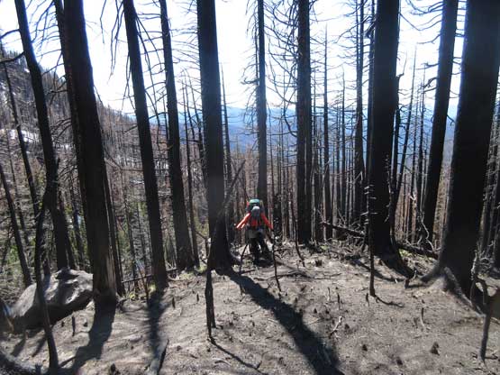
In terms of the access points I don’t think Woodpecker Ridge is the mostly commonly used one but that’s the beta I had from Colin’s recent ascent. The trail is in a great shape but there’s some annoying up-and-downs and the forest had just undergone some large wild fire. All the timbers were seriously burnt and our hands turned black in no time as soon as we touched the logs. The sun’s also beating down mercilessly. Upon reaching the PCT junction we turned left (north) and there came more up-and-downs and burnt forest. The only running water was a small stream near Jeff Creek crossing and we did fill up the water bottles there. Another couple miles later we hopped across Russel Creek and then we headed straight up into the forest. Bushwhacking was none-existent but our progress was slow due to the heavy packs and the afternoon heat. It surely felt like a grunt. Towards the treeline we utilized some snow to bypass the dense bush but at other times we had to ascend some loose volcanic choss and that’s considerably less fun.

Hiking up Woodpecker Ridge trail in the burnt forest

Joining the PCT now. This is the only tarn along the way

A close-up shot of that tarn. Too dirty to drink from it.

The Pacific Crest Trail (PCT) definitely has some engineering in it.

Lily and Lena hopping across Russell Creek

Continuing on PCT for another two minutes before bailing into the bush
Easy travel up the burnt timbers.

Utilizing snow for as much as we could. Easy going.

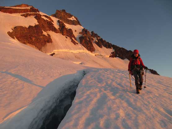
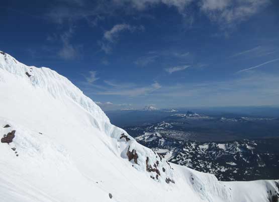
First full-on view of Mt. Jefferson and Jefferson Park Glacier

Ascending volcanic choss wasn’t as fun though.
We past quite a few excellent bivy sites along the way but the day was still young. Our bodies wanted to drop the packs but to shorten the summit day we had to camp higher. The plan was to carry on all the way to the top of the high divide separating Jefferson Park Glacier with Whitewater Glacier and I had to say the last 300 m of gain was no fun. We also didn’t find that “perfect site” so traversed leftwards towards Whitewater Glacier, and on the edge of that glacier we found a piece of flat ground. Wondering around we even saw a freshwater tarn. Not bad, not bad…

The ridge gets wider here and we merged back onto snow

Mt. Hood in the distance
We decided to carry on for as far as possible on Day 1
Me and Lena slogging up. Photo by Lily Q.

This seems like a perfect campsite.

There’s a freshwater tarn nearby. I decided to drink straight from it…

Me surveying the route. Photo by Lily Q.

This is just a northern sub-summit of Mt. Jefferson massif

Hanging around camp.

Another look at Mt. Jefferson our objective

This is a close-up shot. There’s still 700 m elevation gain.
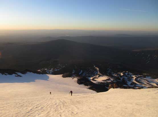
Sleep came easily after 6 hours of heavy duty of gear hauling. The next morning our alarm went off at 3:30 am and in an hour we started the plod. The snow had undergone a full depth freeze.. Crampons on. The faint set of tracks by Colin’s group was still partly visible so there’s no route-finding for us in the dark. About halfway across Whitewater Glacier there came the alpenglow and sunrise just as expected. We were all too busy taking pictures to notice how long this glacial bench traverse actually was. In terms of the glacier travel we just had to follow the tracks but there were at least three bottomless crevasses that we had to walk around. Towards the south-east side of the mountain we maintained a horizontal traversing mode and then zig-zagged our way to hit rocks on the SE Ridge proper.
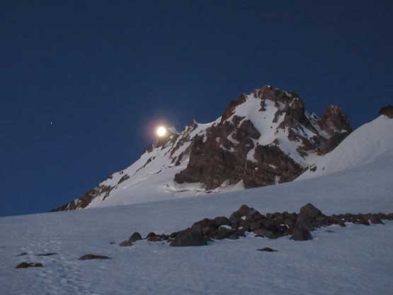
A full moon showed up behind our objective.

Lily walking on Whitewater Glacier with her headlamps on…

This is the first major crevasse we had to walk around.

There are ramps and rolls on this glacier.

Easy walking. We basically walked with camera on one hand.

Alpenglow on the east face of Mt. Jefferson

It’s sunrise time. Note the golden reflection
This is another crevasse that we had to bypass. Couldn’t see the bottom of it.

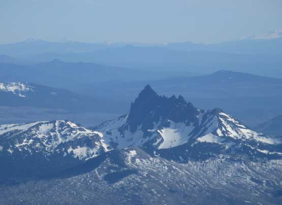
Three Fingered Jack looks very sharp and impressive

Lena and Lily inspecting the views. Still had one bowl to traverse
Ascending easy snow to reach the SE Ridge’s rocks.
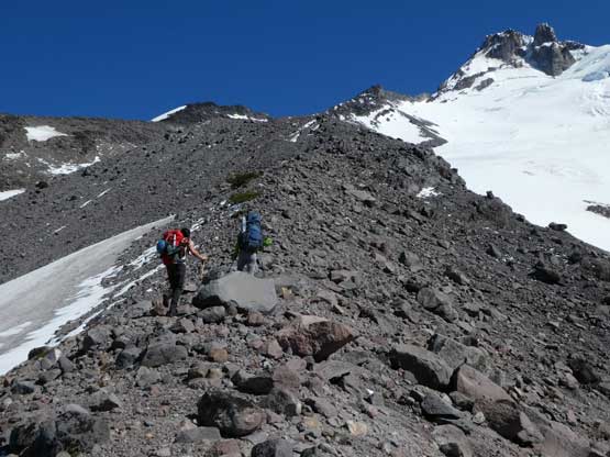
The general bearing now is to ascend SE Ridge to the “Red Saddle” high up directly underneath the “south pinnacle” but there’s route-finding in micro-terrain which none of us came prepared for. This whole section is bloody long and seemed to drag on forever. Because the ridge looked dry we just removed the snow gears and the line we took was a straight-up kind of attack. There’s a buttress about 3/4 of the way up that looked sort of doable, but actually not. We were forced to bail climber’s right onto some steep snow to bypass it and this wasn’t without difficulty. At least an hour if not more was wasted but nonetheless we got back on route, made to the “Red Saddle” and resumed.

Ascending the SE Ridge. We should have crossed this patch of snow

Lily scrambling up the typical rocks on SE Ridge

This is the off-route pitch we did. Good for photos though.
I opted to climb steep snow to bypass instead of the rocks. Photo by Lily Q.

Arriving at “Red Saddle”, first view of the west horizon

Me with the south pinnacle behind. Ready for some fun?!
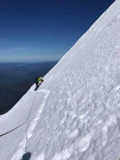
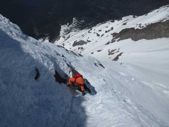
Upon seeing that “terrible traverse” across the west face of summit pinnacles we decided to don ropes and gears right away with me leading across pitch by pitch (30 meters). The first pitch was relatively easy but the next three or four pitches were very difficult. The snow was more like rotten rime ice and the foot placements were mostly front-pointing. On top of that we had to cross at least three major runnels and that greatly reminded me Lincoln Peak from a week ago. I have to say cutting a high traverse across the first bowl was no easier than the “uber airy upper traverse” on Lincoln Peak, only to be twice as long… Crossing the first bowl took us probably three damn hours so upon seeing the next bowl I said we had to speed things up by soloing much of it. Again, the terrain turned out to be harder than appeared and the entire process was calf-burning front-pointing especially towards the NW corner.

Lily and Lena starting the “terrible traverse”

Lena just about to climb into a large runnel. It’s strenuous

Me banging in a picket. Photo by Lily Q.

Continuing the traverse. Note that we were now in the sun.
Me on an easier pitch. Photo by Lena T.

Back to soloing to speed things up… We really had to hurry up.
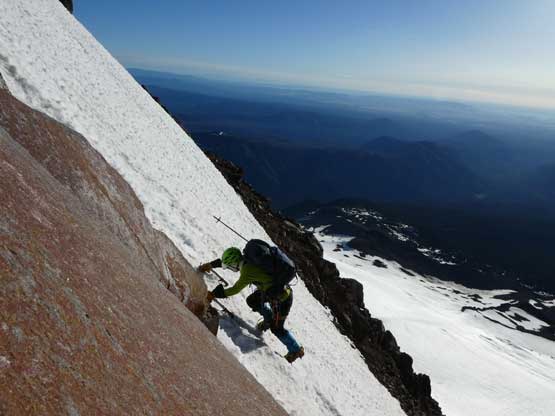
We did find a flat-ish stand on a rock and bang in a picket to secure ourselves, and then I opted to lead the next pitch diagonally up climber’s left onto a ramp system. The terrain looked like snow but “kicking step” was still impossible. For the whole pitch I had to swing hard on both tools and for every chance I could kick in a firm step (usually by kicking half a dozen times) I would rest one minute to release the calf stress. The next pitch saw me firstly angling to the right but soon back climber’s left into a rime chimney. Climbing up that chimney felt like pure ice climbing as I had to literally haul on the tools to drag myself up. This brought us pretty much onto the North Ridge.

Lena partway up Pitch 1 of the rime ice ramp.
Climbing up the rime chimney on the second pitch of this ramp.
Not sure what’s the terrain behind an obvious rock/rime gendarme I climbed up onto the north ridge proper and hopped over to the other side, relieved to see the terrain’s slightly easier on the east side. However, much of the east side was free of snow so I took the gloves off and stored the ice tools. The crampons stayed on because the position was too awkward to sit down and swap gears. I gingerly led across an exposed down-sloping ledge to the base of that crux 5.3 rock step and saw a hell lot of crampons marks on the slabs probably made by Colin’s group a week ago. I tried all strategies to climb that rock step but couldn’t commit because there’s no feet whatsoever. The only possibility for me was by aiding using both ice tools so without further complicating things I built a two-cam anchor and brought the girls up. Lena could lead 5.9 slabs so my plan was to let her lead that step. But once everyone’s brought to the station another problem arose as there’s simply not enough room to stand three people so I accepted the challenge and went for lead. Despite hauling hard on an ice tool hook I still asked for a boost (given my Lily) before able to mantle up the step. This was freakin’ awkward but worked. Too bad I had virtually zero experience on mixed climbing so crampons-on-slabs simply doesn’t make sense.. Above the rock step there’s a very large belay station with loads of slings.

Lily coming around the corner on north ridge. It’s a sharp transition to rock

Lena pulling up the crux 5.3 step.
Onward the terrain looked easier but since the ropes were out we decided to pitch the last section. The scrambling was “3rd class” for the most and I only put in one cam about halfway across and the next thing I found a large horn, put a sling around and belayed Lily up. I then went for the true summit while Lily belayed Lena up the last section. The summit celebration was short as we had to think about how to get down this thing. I honestly wasn’t too sure but upon seeing Colin’s anchor from last weekend I had a plan. Looking down the rappelling gully we could see at least a large patch of snow about halfway down so our decision was to break that double-length rappel into two.

At this point the summit isn’t far away.

Summit Panorama from Mt. Jefferson. Click to view large size.

This is that south pinnacle. It’s a prove that we made to the top

A southern view towards the Sisters and Three Fingered Jack, etc.

This is looking over the northern sub-summit

Lily belaying Lena up the last pitch.

Me on the summit of Mt. Jefferson
Too mentally drained from leading the last five our six hours I opted to take a rest break. Lena had more experience in rappelling so she went down first, built a picket anchor and backed up with an ice screw. Lily and I went down afterwards while kicking down a shit ton loads of ice chunks. Not wanting to linger any longer than necessary I immediately led down the next rappel (on that single picket), down through a series of melted-out rock ledges to the slopes below. There’s more ice falls coming down and Lily got hit by twice (thankfully with no injury). Lena and Lily decided to do two additional rappels off the 45-degree ish terrain but to safely traverse back across the first bowl we couldn’t afford leaving more pickets behind. I volunteered to remove the pickets and down-climb the two pitches so problem solved. At this point we had descended off the ice section onto some kick-able snow (due to the afternoon heat).

Rappel #1 into the gully. Ideally you need two 60-m ropes
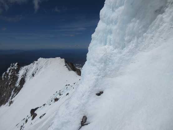
There’s a lot of ice on this mountain…

Rappel #2 off the gully. We had to leave a picket behind
This is the easier terrain between the two bowls.
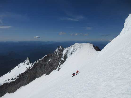
Checking out the first bowl none of us wanted to take our high traversing line. There’s again a shit ton loads of ice chucks falling off the rime-covered summit pinnacles and that entire traverse was exposed to that. Our strategy was to rappel off a vertical lip of snow into the bowl, down-climb and then re-climb diagonally out of the bowl. Our hope was that the snow would be softer inside the bowl so there’s no more tiresome front-pointing involved. This worked out perfectly well except for to built a trustful anchor in the slushy snow we had to spend some time burying a deadman (instead of a vertical picket as what we normally do). The rest of the traverse and re-ascend was easier than expected. We simply simul-climbed it and I did place the only picket I had about halfway up.
Looking across the first bowl. We traversed right underneath the rocks

Exploring an alternative way down and across
The views were really distracting.

We built a deadman and rapped over this lip of vertical slush.

And then did a long traverse across the bowl and then climbed back up
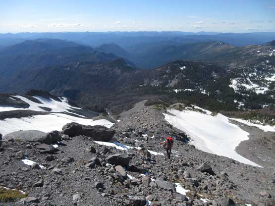
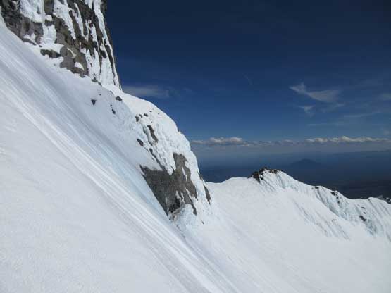
Descending the SE Ridge there’s no way would we reverse that off-route section so we had to look for an alternative path. The highway of boot-tracks went down skier’s right side of the ridge so why not. The slope angle was like 35-40 degrees ish for a long while and the snow was slush. I down-climbed the entire stretch facing into the slope but did make some very large plunges so very fast going. Lena glissaded it while Lily gingerly followed my steps down. This snow slope deviated a bit from the SE Ridge proper so we had to traverse some horizontal stretches which involved another snow slope. And then we plunged on snow beside the rocks and eventually merged onto Whitewater Glacier. The few kilometers of glacial walk was a hell of a tedious process. We had to traverse the entire east side of the mountain from the south end to the north end and that felt long.. Our round trip was over 15 hours return from high camp so logistically none of us wanted to break camp and head down.

Victory shot!
Now I wanted to do Three Fingered Jack…

There’s still a lot of down-climbing awaits

Maybe glissading is a faster way to get down..

More down-climbing. I did this entire slope facing in.

You can see Mt. Jefferson’s shadow in foreground
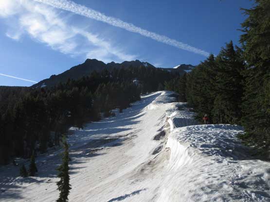
Wind picked up considerably overnight and at time I thought my tent would get ripped, but thankfully it held. The wind died down in the morning (thankfully) to give us a decent window in breaking camp. Descending the ridge was fast and fun. We utilized snow and dirt for as much as possible to speed things up and in less than hour we had lost 800 m elevation back to the Pacific Crest Trail. Of course the game wasn’t over yet. The hike-out on PCT and then Woodpecker Ridge trail was quite a numbing experience, both physically and mentally.

The morning of Day 3 from camp

The incredibly broken Jefferson Park Glacier. There’s an Alpine III route

Partway down the ridge, looking back. Last full view of our objective
We hiked down on this strip of snow

Hopping back across Russell Creek

Quite a lot of dead-falls on the PCT

It’s that tarn again. Mt. Jefferson in the bag..
There were two other cars parked at the trail-head and we assumed one of which was Colin’s (he’s doing a repeat with another friend). Despite the tiredness I volunteered to drive down that winding road and then all the way to Salem, OR. Lily took over the drove all the way to Olympia, WA before I took over again dealing with the horrendous Tacoma-Seattle gong show. It was a brutal exercise but good for upgrading one’s level of patience. The entire I-5 and I-405 was a shit show. Thankfully I had a Waze app which knew how to avoid the traffics. I had absolutely no idea where it’s leading us to but apparently it worked. After dropping Lena in Bellevue the rest of the way back up north was uneventful except for that hour-long border delay. It’s Sunday afternoon so what else one can expect…
Overall I would say the difficulty of Mt. Jefferson in spring time exceeds my expectation – pitch by pitch of technical terrain on snow, ice, rock and mixed plus a full 3-day assault is needed for averaged party. I would probably recommend to just do the standard SW Ridge route in summer time but even so expect it to be harder than you might think. I also have to thank Lena and Lily for joining and pushing it through. They might not have done nearly as many difficult objectives as I do, but they certainly put in a hell lot more effort in training their mountaineering techniques. I’m more of the bold, soloist type of climber and it’s a valuable experience for me to learn how to do these stuffs in a textbook’s fashion, as well as practice actually leading on technical snow climbing. I used to climb steep snow only by way of soloing. Believe it or not this was my third trip ever using snow pickets and my first time actually banging them in at least a dozen times. All in all this was another memorable trip and the bones – my 34th “Ultra” in the bag.
